By Julian Dierkes
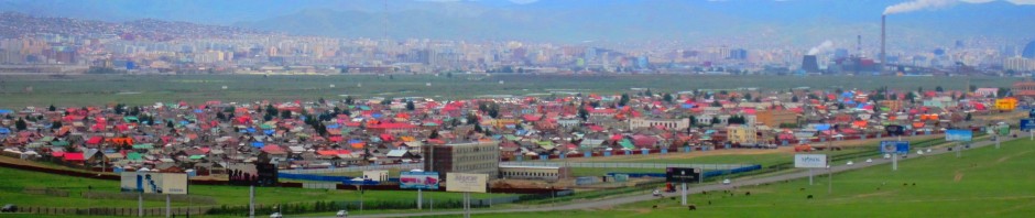
I’ve been touring through the Mongolian countryside periodically for over ten years now, having recently visited my 17th aimag, just four more to go.
17 aimags visited and counting… Can you guess where I’ve made it to? pic.twitter.com/9F16JfgS3v
— Julian Dierkes (@jdierkes) August 24, 2018
On these visits, I’ve always been puzzled by the location of towns. My musings below will surely betray my ignorance of Mongolian history, military and environmental, but sometimes blogging is about thinking out loud, so here it goes…
Where I’m Coming From
… literally. That is, I grew up in Germany where the location of old (medieval and older) towns always seems quite clear. Either they are located on an important trade route or bottleneck (all the -furts that offer easy crossings of large, navigable rivers, all the ocean harbours), or there is an obvious military use (typically a castle overseeing a cross-roads of some kind).
Clearly, that logic does not apply to all towns and cities. The older the city (i.e. Roman origins) the clearer the origins seem, the further Southwest in Germany (i.e. Roman influence, but also proximity to Central European historical “action”), the more this logic holds, at least at a very general level.
What I See in Mongolia
Most settlements that I see do not seem to be located in the very spot they are for reasons that are obvious to me. Again, this is likely due to my ignorance, so if you can educate me, please do comment below.
Of course, historical nomadism means that settlements are not as prominent a feature of (political) history of Mongolia as they are in Europe, for example.
I see soum and aimag centres that are often situated in the middle or toward the middle of large plains or valleys with no distinguishing features to that specific location. Yes, there are some rivers (Khovd and Choibalsan come to my mind from recent travels, Ulaanbaatar as well, obviously), but these are not navigable, nor are they that difficult to cross (typically, at least today, not being very deep).
For other aimag centres, they seem to be located in the middle of a large plain with no obvious factor that is visible to my ignorant eye to recommend this location over others. That holds for centres like Chinggis (Khentii) or Arvaikher (Uvurkhangai) or Dalanzadgad (Umnugovi).
The Mongolian countryside is full of vistas that lift the soul by the breath-taking depth of the steppe, these vistas are certainly meaningful to me. But, most cities are not located at such viewpoints.
Monasteries
The most common explanation offered for the location of settlements is that they are where there are/were monasteries. That logic is sometimes difficult to recognize since most monasteries were destroyed in the 1930s, so without local historical knowledge, it is often hard to see the co-location of a monastery with towns.
Some of the prominent exceptions to this general pattern are Ulaanbaatar and Tsetserleg, both settlements where monasteries are a visible part of the cityscape today.
For many aimag and soum centres that were founded in the socialist period, their location was pre-dated by monasteries, or so I am told.
That gets me into the even-more-difficult topic of why monasteries are located where they are. It seems to me that there are two obvious ways to look at that question: dogmatic and pragmatic.
If there are shamanistic or geomancy reasons for the location of monasteries, those are clearly not accessible to me. That origin of location is also not common in Europe as many old towns predated the institutional history of the Church so that clerical centres were located in towns, not the other way around.
If the location of monasteries was driven by factors that are inaccessible to me, it is no wonder that I continue to be puzzled by the location of towns.
But if there are pragmatic elements to a religious logic, I would guess that monasteries’ locations do serve the nearby population in some way. In that case, pointing to the monastery-origins of settlements simple bumps the question up one notch in some historical sequence.
Military History
There are no defensive castles or even fortifications in Mongolia as far as I can tell. Even though some dynamic in Mongolian history is clearly driven by military history, the fact that settlement locations did not come out of locations of fortifications must be driven by a very different military doctrine.
Mendee has been kind enough to help me understand this a bit more, as he has in general for this post.
Mongolian historical military strategy is not built on mass, but on speed. Anyone who is familiar with Chinggis Khaan’s conquests will be aware of that. What that means for the location of settlements is that the logic of the fortified castle on a hill that oversees most routes of approach as it holds in Europe, is not relevant in Mongolia.
Instead, any location that is to be defended will likely be defended by deploying observation posts to a number of surrounding hills to report back to a main force if some kind of threat emerges. Such a deployment assumes some logic that a location is to be defended, but once that decision is made, military strategy does NOT dictate the construction of fortifications the way that European or Chinese military strategy does.
Settlements of any kind thus do not lead to a castletown. I am not sure why archers, an important element to Mongolian military strategy, would not be advantaged by a defensible, elevated location, but it appears that archery was deployed only in conjunction with or as a cavalry, so perhaps the question of a defensible perch simply does not arise.
Environmental Conditions
A contender in determining the location of settlements might be environmental specificities. For example, Khovd is not nearly as cold as some of the neighbouring regions like Zavkhan, Uvs, or Bayan-Ulgii. Perhaps this was a significant factor in making Khovd a centre for Western Mongolia from the Qing dynasty until today.
Given Mongolia’s very harsh climate, it is entirely plausible that variations in climatic conditions or micro-climates are an important factor in making some locations safer than others. Prevailing winds, availability of water, temperatures, accessibility in winter, etc. these might all be reasons for locating settlements in specific places, even independent of a livelihood logic that may also be closely linked to location decisions.
Livelihood History
Obviously, livelihood considerations loom large in a pastoral society coping with very specific challenges of a continental climate and specific ecology. These considerations are directly linked to environmental conditions.
Any settlement, whether it is a monastery, military or trading outpost, would involve some residents who would not be active in agriculture, so that the surrounding area and population would have to be productive enough to support such a population. The quasi-feudal operations of monasteries under Chinese colonial rule may have been a good example of this requirement, where the extraction of significant amounts of agricultural products were required to support a population of “non-productive” monks that may have reached a third of the population at some times in some places.
While Mongolia may generally seem fairly barren (outside of areas that are rich in water and less extreme climates such as northern parts of today’s Khentii, Selenge, or Bulgan aimags) there are significant local variations in the availability of water, the quality of pasture, and the variety of pasture.
On a recent visit to Khvod, it was striking – especially in a summer that saw significant precipitation and even flooding – how much water there is when approaching the town from the North. It is this amount of water that makes Khovd famous for watermelons today, as their production can be sustained with significant sources of water.
View this post on Instagram
Velvety riverside grass, high ger density for summer in Khovd. #Mongolia
As a region, Khovd City, may have been more able to support a military garrison with foods than other locations in the West, determining its location as a Chinese trading post, but also as a military base. That may also have been a factor in the location of monasteries and, later, towns.
Some Exceptions
Obviously, there are some exceptions to my puzzled look at the location of settlements. Erdenet is Mongolia’s second-largest city, but its location was determined by the nearby copper mine.
Tsetserleg is the capital of Arkhangai and its location seems much more obvious to the visiting European eye. It is perhaps the most attractive location for an aimag centre that I’ve visited. Nestled up against mountains, it enjoys a view over a long valley and a generally scenic location. It also is close to a mountain pass that is a route to the West, giving it the sense of a gateway of sorts.
I already mentioned Khovd for its agricultural potential above. But it is also surrounded by breathtaking high mountains that left me less puzzled by its location than other aimag centres.
Addendum: There is a Scholarly Literature!
As it turns out, there is some scholarship on the origins of settlements in Mongolia and Mendee pointed this out to me:
Alicia Campi. 2006. “The Rise of Cities in Nomadic Mongolia” in O Bruun and L Narangoa, eds. Mongols from Country to City. Copenhagen: NIAS Press, 21-55.
Campi classified cities for their origins as trade and agriculture (eg, Kharkhorin, Khovd), monastic (Ulaanbaatar), military (Uliastai), political (Mandalgov), and industrial (Erdenet). Pretty close to my categories, though I left out the political and industrial as recent reasons for the establishment of cities.
But these origins classify the cities and making a case for their original establishment. This classification has relatively little to say why these cities were established in the exact location where they were established! The exception are recently established military cities like the aimag centres of the Govi aimags. The Mongolian government created the
southern provinces along China’s border in a basically north-south pattern with aimagcapitals situated in the north of the aimag s for protection against Chinese invasion and for proximity to the national capital and the central Mongolian heartland steppes.” 44-45
 Follow