Category Archives: importance of place

Story Maps

A story map visually displays data in relation to places, location, or geography, and story mapping is the process of finding and analyzing the connections among human experience and place. Story maps can be simple or complex, low or high tech. And, story maps help in analyzing complex social issues such as human rights, climate change, refugee resettlement, student transcience, and community integration.

First, a simple example.

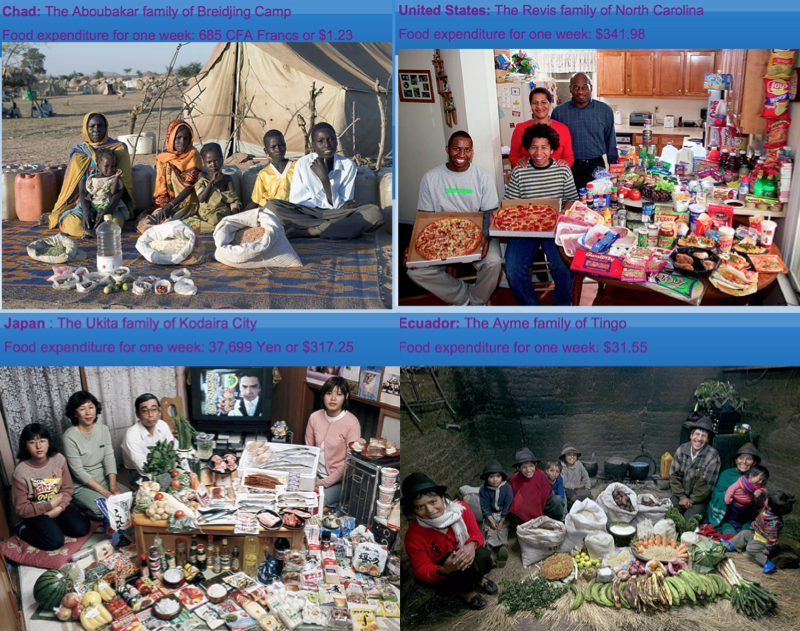
In a study of climate change, researchers worked with Ecuadorian subsistence farmers, used Post-It notes to facilitate a community discussion on climate change. Using a map as the basic reference, farmers in the mountainous central Ecuadorian province of Cotopaxi answered three questions: Has your community changed since you were a child? How has the climate changed since then? Are there any past climate-related events that affected
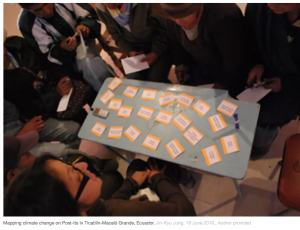
 you the most?

Responses were posted to the map, illustrating connections between place and observed human (such as illness) and climate (such as agricultural pests) events.

While this data collection and analysis was part of larger mixed methods approach, it illustrates how mapping human experience enhances our understanding of climate change. (Here is the article.)

More sophisticated examples.

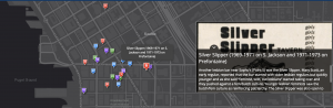
Using existing web based templates (like StoryMapJS) or even Google Maps a story can be build that illustrate events and relationships. These tools rely on a narrative that moves through geographical space and the flow can be in space or time and space. An example of the former might be a subway line or interstate highway along which events, places or people can be placed. This story map of the Green Line train in Minneapolis is a good example. A static map example is of Pioneer Square in Seattle as a center for Queer history in that city. An example that combines movement through time and space is a story map illustrating the shifting population throughout USA history.

Often, story maps use GIS (geographical information systems) software, most commonly ArcGIS. Here is a link to Environmental Systems Research Institute, the most common portal for the use of this software, with illustrations from marketing, social science, and natural sciences. There are lots of examples on this website, but this story map of the experience of Rohingya refugees is a good place to start.

Story maps are often web-based, which facilitates interactivity and reveals movement within the story.

What applications might this have in educational research? Here are just a few ideas.

  1. Student mobility is an issue in the lives of some students, the quality of education received, experiences in school, and the experiences of schools. Mapping student mobility within a district or city combined with interviews, performance data, family characteristics, school environment and so on could provide insight into the experience of transcience and help schools plan better for the inevitability of student mobility.
  2. We know standardized test scores correlate as much with social class as with ability. Social class is closely linked to neighbourhoods and so mapping scores onto neighbourhoods, with additional information about income, types of housing, and cost of housing would reveal this relationship succinctly.
  3.  Generally, one might examine issues of space and educational inequality. Inequality that stems from race, ethnicity, or special needs are geographically unevenly distributed and revealing that distribution in communities, districts, schools and even classrooms could be done with story mapping.

Design meets social science

I spend some time when teaching research methods trying to help students understand the notion of material culture… not so much the archeological notion of material culture, but the human fabricated world we currently live in. We are so accustomed to just asking or watching people in order to understand human nature that we overlook the rich data record of objects, spaces, environments we have created that say so much about us. From an anthropological stance we can make some sense of what is valued by examining housing styles, graffiti, music, cityscapes. But, so what? Charles Constantine’s thesis looks at funeral practices and rituals and although it is not a stellar piece of social science research it’s a pretty good description of contemporary North American death traditions. Based on this investigation, and the real point of Constantine’s work is to reconsider design elements of death rituals–coffins, urns and burial places. Influenced some by the ‘home funeral’ movement, Constantine re-envisions what the things and places associated with dead bodies might be like, especially in an affirming, positive way for the living.

So he designs a coffin that is a coffee table. Urns that can be used to ‘plant’ the dead thus contributing to life. Discussions of his work on design blogs haven’t been very kind–my guess is that says more about a cultural taboo on seeing death as part of life more than it does about the ideas or the design. His designs are innovative (although I personally don’t like the aesthetics of the coffin/coffee table) and quite beautiful (his urns are lovely organic pieces of sculpture).

I am left wondering sometimes why we do social science research. I don’t have a strong utilitarian bent, I think knowing about is a worthy end. But I don’t mind seeing this marriage of understand the social world through research with an eye to a thoughtful reconstruction of our social world. I don’t suspect Constantine’s designs will change the big business of death, but how informative to have this unique perspective on the funeral practices we take for granted.

Photo essays

Photo essays have been around for a long time ~ they are a series of photos, sometimes with captions, descriptive and/or explanatory text. Usually photo essays illustrate something that is more immediately knowable through an image, often by evoking an emotional response, but often also by showing. A photo essay structures a collection of images either in a specific order to illustrate the progression of events, emotions, and concepts OR thematically to illustrate concepts. Photojournalists and photographers create photo essays and intuitively portray lived experiences; social scientists create photo essays and explicitly explore and represent lived experiences. One isn’t better than the other, and they are often indistinguishable.Some photo essays are only images, such as Walker Evans and James Agee’s classic work Let Us Now Praise Famous Men.

Photo journalists use this form of representation to report on events and experiences around the world. This example of Syrian women who have taken up arms captures a single idea poignantly.

Photographers, like Lauren Greenfield, uses images to illustrate our own culture, especially youth culture in America. In Fast Forward, she captures the contrast between kids growing up in Los Angeles living lives of affluence and poverty, all in a sped up world.

Some photo essays use constructed images to tell a story, as in Hungry Planet: What the World Eats, an essay illustrating how globalization, migration and rising affluence are affecting the diets of communities around the globe by focusing on 30 families in 24 countries. Each chapter of the book features a portrait of a family, photographed alongside a week’s worth of groceries. There are many images of families food shopping, cooking and eating, but the primary images are staged ~ the family in the background, and the food they eat in the foreground. Text describes the details or the week’s food, including the cost of the food.

Photo essays can also be collaborations, multiple photographers/researchers working together. High school students in LA used photography to explore immigration in their communities.

Sophisticated uses of media allow for combinations of photographs, texts, and infographics (including interactive formats), a less static form of photo essay. An excellent example of this is Segregation Now, which looks at resegregation of schools in the U.S. south, Tuscaloosa specifically.

Humans of New York (HONY)

The Humans of New York (or HONY) is a photography project started by one person in 2010 and has developed into a blog with images and snippets of stories from New Yorkers. Brandon Stanton, the photographer and writer, describes the blog: “With nearly one million collective followers on Facebook and Tumblr, HONY now provides a worldwide audience with glimpses into the lives of strangers in New York City.”

The front page evolves as photos and stories are added and looks like this. The blog is in the genre of street photography, with the addition of the stories. While Brandon wants to give us a glimpse of the lives of New Yorkers it is also possible that he is unwittingly creating an ethnographic data record that reveals much about the culture of, in this case, New York City, but perhaps more generally urban USA. The ability to digitally create, store and distribute data opens possibilities for a new kind of field work.

HONY has spawned a host of clones, especially on college and university campuses: Simon Fraser University, Humans of Houston, Detroit, Miami and Seattle, Humans of Brown University, Binghamton University, Lehman College, and Reed College. The purposes of the clones may vary but each creates a census of people in a given place, a data record of people within a cultural context.

Detroit ~ understanding urban development and decay through urban exploration (urbex)

Detroit has become a living laboratory for studying the creation and decline of urban industrial cities. The scale of deterioration in Detroit far exceeds that of other declining urban areas.

Detroit population:
1910 286,000
1950 1,850,000
2010 713,000

When the population of cities swell infrastructure develops to accommodate their needs, and as that population shrinks the infrastructure remains, leaving a ghostly reminder of these demographic changes. Houses, schools, churches, streets remain but are abandoned.
These abandoned spaces remain and as they deteriorate the land returns to what it was before the city developed. In downtown Detroit open fields have appeared amidst the remaining buildings… some of those spaces are being claimed as urban gardens.

One study that is chronicling the changes that Detroit continues to experience in this continuing story of urban change is Detroit Urbex. The intent is to “raise awareness of the social and economic challenges the city of Detroit faces through photography.” This is part of a movement called urban exploration or urbex, the exploration of man made structures, often involving exploration in places that are off-limits, and complete with suggestions for the kit for explorers (urban spelunking gear!).

Detroit Urbex’s photographic record is rich and deep, connecting the past and the present. Now and Then is a kaleidoscope of past and present images that are remarkably poignant. These images from Cass Tech High School, the most prestigious Detroit High School ~ now demolished, illustrate this technique.

Using aerial photographs

Aerial photography has been around for a long time ~ indeed there was a time living on the Canadian prairies where aerial photographers took pictures and then sold them to farmers, a sort of self-portrait of their homestead. My grandparents proudly displayed such a photograph in their living room and as a child I found it a fascinating perspective.

Google Maps provides an interesting resource for using the aerial perspective to examine constructs such as land use and housing patterns. For example, John Hill in this blog post looks at housing patterns, particularly suburban housing patterns that show an evolution from the sterile grids of suburbia characteristic of early suburban development, a pattern Thomas Jefferson laid down in the 18th century. His analysis of housing patterns illustrates an evolution that considers issues of density, community, and aesthetics based on the housing patterns (grids, fairway housing, fly-in homes, canal homes, cul-de-sacs, gated communities, tract mansions (what some folks call McMansions) and so on) we see in aerial photographs. This analysis clearly illustrates changes over time, concluding with suburban planning that reflects a contemporary interest in being ‘green,’ developments that encourage transit use, walkability, mixed-use spaces, and energy efficient construction.

See also Context and Perspective

Street Ethnography

Street ethnography is an emerging research approach that focuses on public exterior spaces… sidewalks, parks, neighbourhood spaces. Both the ethnographer and the ethnographic participants are moving through these public spaces and so are engaged with each other in informal ways as both use these spaces in a fairly equal way. The tools for street ethnographers include neighbourhood walks, going along with ethnographic participants, and photography.

A good illustration of street ethnography is, Urban Fieldnotes, a mash-up of research and street style blogging. Blogger Brent Luvaas, a visual and cultural anthropologist & Assistant Professor of Anthropology at Drexel University, describes Urban Fieldnotes this way…

Urban Fieldnotes is a street style blog documenting fashion, style, and dress on the streets of Philadelphia and beyond. It is also a blog about street style blogging, an experiment in auto-ethnographic research and open-source fieldwork that is part of an ongoing project entitled “Street Style 2.0: New Media and the New Politics of Fashion.”

His research project is connected to the rise of street style fashion blogging as a form of amateur ethnography that challenges prevailing modes of expertise in the fashion world. Just to make sure you know this is research, he also says…

Your comments and suggestions are welcome, but please note that any comments posted to this blog may be used in future presentations and publications, both print and digital, by Brent Luvaas.

Street style blogs are plentiful, but perhaps one of the mostly widely read is The Sartorialist, but Luvaas provides a long list of street style blogs from around the globe. Others he might have included are Advanced Style, which focuses specifically on ‘older folks’ and Bill Cunningham’s work for the NY Times. And there are an increasing number of models come street style bloggers, like Hanneli Mustaparta and Christine Reehorst.

There isn’t much written about street ethnography, although R. Weppner’s 1977 Street ethnography: Selected studies of crime and drug use in natural settings is a good resource, if you can get your hands on it.

negative space

180px-sbmothNegative space is a design concept and refers to the space around and between objects ~ it is a concept that crops up mainly in art and interior design. The classic illustration is the black and white silhouette drawings.But it is an interesting idea that has many possible other uses. For example, in sports, to score a goal you have to see and aim for the negative space, that is, where the goalie is not ~ if you have played sports you will know that it is a special skill to see that space, rather than just seeing and shooting at the goalie.

When we think about humans and environment, one use of this concept might be the places humans have abandoned, spaces where once we lived, worked and played but which have failed to serve our purposes. Abandoned spaces are everywhere and there is a rich photographic record of them chronicled by hobbyists and sociologists. Much of the time they are buildings (residential or industrial) that have been abandoned, but sometimes they are simply promises of what was to come. Many years ago I spent a sabbatical in central Florida, an area dotted with planned communities that never materialized. Subdivision paved roads often with unconnected street lighting give the impression of urban crop circles.