Local Issues: Expanding Sutherland Waterfront Park (Part I)?

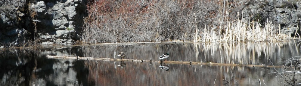
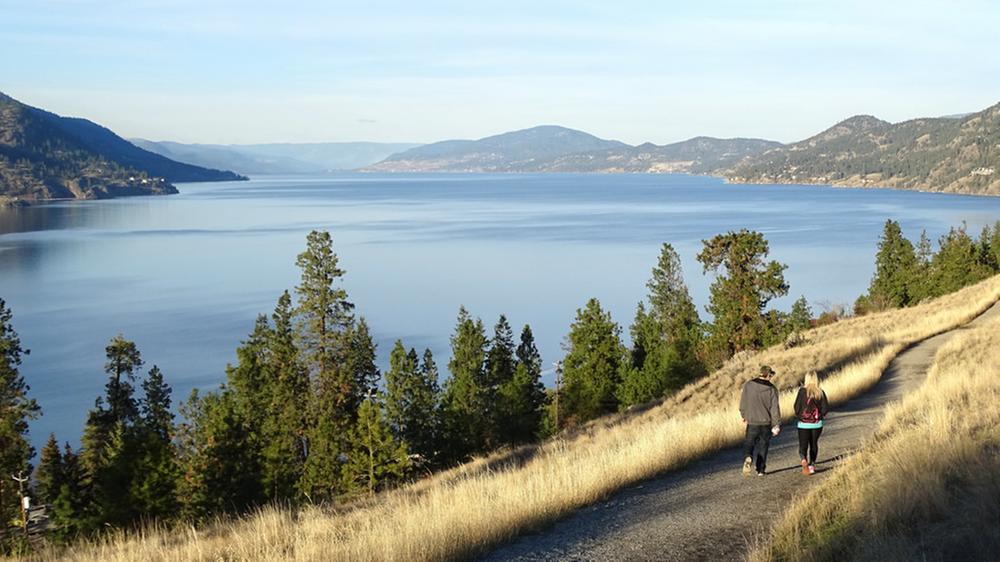
Okanagan rail trail. Photo credit Tourism Kelowna.

I like urban parks and pathways.  I believe that public green spaces are important for our connection to the environment, to each other, and for encouraging healthy physical activity.  My education as an economist also makes me wonder about measuring the value that public green spaces in our cities provide.

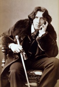
Oscar Wilde is credited with defining a cynic as someone who “knows the price of everything and the value of nothing.”  Practitioners of the dismal science (economics) are often seem pretty cynical, and Wilde’s definition sees frequent application to economists who talk about the value of things like public parks.  Maybe I’ll confirm Wilde’s cynicism.

One of the pleasures of being an academic is learning about the research others are doing.  Recently, I attended (virtually) a talk by Dr. Peter Tsigaris of Thompson Rivers University.  Dr. Tsigaris had charged his students with calculating an estimate of the value of the services provided by a number of Kamloops city parks.  Many economists would argue that the best approaches to estimate these values is to carefully observe and interview park users and/or carefully analyse how property prices are affected by proximity to the park.  Both of these primary research approaches are expensive and time consuming, beyond what can be achieved within the time available for a class project.

Kenna Cartwright Park. Photo credit Tourism Kamloops.

I would be one of those people who would reveal a high value for using or living close to protected green space.  Conducting and reviewing this type of research reminds me that my own values may not be near the average of those in my community.

The cost and time challenges of primary research have created a demand from policy makers for quicker and cheaper ways to come up with value estimates.  The resulting approach, known as ‘Benefit Transfer’, consists of adapting values from primary research done somewhere else to the site where a value of services is sought, those Kamloops parks.

The trick is finding primary research that is similar enough to the thing for which a value is sought.  One solution to this challenge, known as ‘Meta Analysis’, is to collect results from a number of previous research projects and look at how differences among these projects are reflected in different value estimates.  One recent meta analysis, by Bockarjova, Botzen and Koetse (2020), collected results from 60 previous studies, identifying features of green and blue nature and the urban settings where they are that predict the estimates of the value of those services reported in those reviewed studies.  The results of this analysis were used by Dr. Tsigaris’ students in their Kamloops park value estimates.

In terms of estimated value provided per hectare of protected area, some of the important features identified by Bockarjova, Botzen and Koetse include:

  • Area: Larger parks provide more services.  The value of the services per hectare falls as the protected area size increases.  That means that all else equal, two urban protected areas provide more service value than one protected area that is double the size.
  • GDP: Urban areas with higher average income get more value from their urban protected areas.
  • Population Density: Urban areas with more people per unit area get more value from their protected areas.  As we densify our cities, providing protected areas is even more important.
  • Park: If the type of protected area is a park, providing a variety of recreation and public use opportunities, it provides substantially more service value than other forms of protected areas.
  • Water: Protected areas that involve water as well as land generate more service value.
  • Complexity: Protected areas that provide a variety of landscapes provide a variety of environmental services. Some research showed this to generate higher value.

The analysis results in equations that can be used to predict the per hectare value of protected urban space. I’ve put the equations at the end of this post. If you are interested in the details, have a look.  To apply the results developed by Bockarjova, Botzen and Koetse (2020), find and plug in the relevant values for an existing or potential protected area.

Note that analyses like these identify things that are common across the previous research.  They are not able to capture the influence of unique features of individual protected areas.  They also tend to be conservative (lowballing benefits and highballing costs), as the analysts prefer to underestimate the values.  This is done so that possible mistakes in their analysis are more likely to result in a bigger value than a smaller value.  Decision makers who might use these numbers prefer to be accused of making an investment that generates a return that is larger than expected rather than one that is smaller than expected.
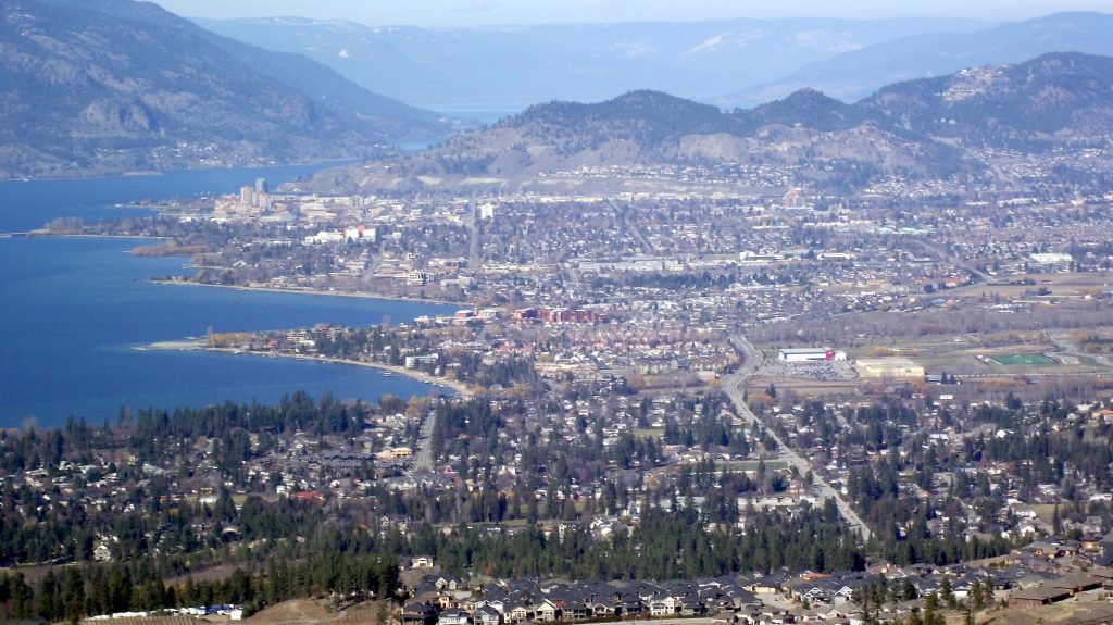
Knox Mountain Park

Knox Mountain Park. Photo credit iHeartRadio AM 1150.

Knox Mountain Park is an iconic park in Kelowna.  It covers a bit over 367 hectares.  It provides a variety of landscapes and recreational opportunities.  It is not a small urban park, nor does it provide much connection to water.

The city of Kelowna has a population density of 680 persons per square kilometer, and the larger metropolitan area (RDCO) has a population density of 76 persons per square kilometer.  The per capita GDP in this area is $46,828. If we plug these number in we get the following results.

Studies used in model:All StudiesEuropean Studies
Per hectare annual value: 103,425 99,124
Total annual value:37,956,84036,378,570

It is rewarding to find a large number representing the value that Knox Mountain Park provides to Kelowna.  Based on the proposed management plan for Knox Mountain Park (Management Plan Update 2022), the city is proposing to spend something over $340,000 per year on maintaining and upgrading the quality of the services provided by the park, which amounts to less than one percent of the estimated annual value of those services.  The people of Kelowna love Knox Mountain park, and there is little chance that land will be taken out of the park.  In fact, in recent years, the city has acquired some additions to this park which, given the estimated annual value of the services, is likely a good investment.

expanded downtown waterfront park

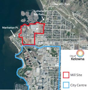
Source credit Kelowna Daily Courier.

We might also use the numbers these researchers have estimated to assess potential land use plans. Recently the Tolko mill in the north end of Kelowna was permanently closed, and planning for the future of the site is underway. Some people, such as myself, would like to see that future including a significant amount of public waterfront. The numbers below are calculated as if five hectares of waterfront park is added to the current 1.69 hectare Sutherland park.

Studies used in model:All StudiesEuropean Studies
Sutherland Park value: 39,007,226 28,846,826
Expanded Sutherland Park value:40,987,97731,458,862
Difference:1,980,7512,612,037

The calculations yield an annual value of more than thirty million in service value from 1.69 hectare Sutherland park, with about two million in annual value added with a 5 hectare addition.  This calculation ignores the fact that there are alternative downtown waterfront parks that provide similar services to what this addition would provide that are close by.  There are more than 26 hectares of waterfront park from the base of Knox Mountain to the highway 97 bridge across Okanagan Lake. If we consider adding five hectares to the current 26.87 hectares of park, then the calculations yield the following.

Studies used in model:All StudiesEuropean Studies
Downtown Waterfront Parks value: 43,091,815 34,338,794
Expanded Downtown Waterfront Parks value:43,357,36734,709,970
Difference:265,552371,176

These calculations result in an annual service value of about $300,000 from the five hectare expansion.  Taken together these results suggest that the value of the services that adding five hectares of waterfront park to the existing downtown waterfront parks would be somewhere between $300,000 and $2,000,000 per year.

How do we interpret these numbers?  The logic behind this approach implies that having Knox Mountain Park in our city is worth about the same as sprinkling $37 million per year across the population of the city.  Likewise, adding five hectares of waterfront park when the Tolko lands are redeveloped is like sprinkling somewhere between $300,000 and $2,000,000 per year across the population.

This value is not distributed equally.  People who live close to the park use it more and gain more benefit.  These residents may pay more for housing (rent or ownership) because they live close to the park, so that some of this benefit is captured by property owners.  For a waterfront park with easy access to food services, some of that value shows up as revenue for businesses near the park.  Some of it will be money saved by people who would otherwise pay it to access other recreational opportunities that are farther away.  In the next part of this blog, I will explore a bit more how these impacts are distributed.

Photo credit Kelowna Now.

To me, a key message is that while from an accounting perspective, parks are cost centers, they are also assets that provide services which can be very valuable.  Expenditures on existing parks are maintaining assets that provide valuable services, and expanding parks are investments to acquire assets that can provide valuable services.  Raising our local taxes to invest in parks can pay a very healthy return to our community!

  • Bockarjova, Marija, Wouter JW Botzen, and Mark J. Koetse. “Economic valuation of green and blue nature in cities: A meta-analysis.” Ecological Economics 169 (2020): 106480.

benefit transfer equations

There are two equations offered in the research paper, one based on all the research they surveyed, and one based only on that research which looked at protected areas in Europe.

Benefit transfer function based on European studies:

\\\ Service\ Value\ per\ Hectare = \exp [ 8.005 \\ - 0.937 \times ( \ln(Area\ in\ Hectares) - \ln(472) ) \\ + 1.496 \times (\ln(GDP\ per\ capita) - \ln(28,007)) \\ + 0.201 \times (\ln(Pop.\ Density) - \ln(211)) \\ + 2.402 \times (1\ for\ Park) + 0.837 \times (1\ for\ Small\ Urban\ Green) \\ + 0.107 \times (1\ for\ Water) - 0.807 \times (1\ for\ Complex) \\ + 4.041 \times 0.218 - 3.424 \times 0.299 ] \\\

Benefit transfer function based on all studies:

\\\ Service\ Value\ per\ Hectare = \exp [ 7.718 \\ - 0.964 \times ( \ln(Area\ in\ Hectares) - \ln(1474) ) \\ + 1.527 \times (\ln(GDP\ per\ capita) - \ln(23,026)) \\ + 0.241 \times (\ln(Pop.\ Density) - \ln(396)) \\ + 1.674 \times (1\ for\ Park) + 0.059 \times Forest - 0.144 \times (1\ for\ Small\ Urban\ Green) \\ - 0.589 \times (1\ for\ Green\ Linked\ to\ Grey) + 0.221 \times (1\ for\ Water) + 0.231 \times (1\ for\ Complex) \\ + 1.900 \times 0.218 - 2.723 \times 0.299 ] \\\


Local Issues: The Official Community Plan

The environment that we have the most interaction with is that near where we live, work and play.  The shape of that landscape is largely determined by the decisions of local governments, governments that have, by provincial law, been given the authority to plan land use.  These local governments operate within the constraints of the provincial legislation that defines them, and that puts some limits on their decisions.  The Agricultural Land Commision Act (which created the Agricultural Land Reserve) being a particularly prominent policy in this province.

https://web.archive.org/web/20161026172516/http://www.panoramio.com/photo/87149966

Many communities in British Columbia adopt an official community plan (OCP) and some are required to.  That plan must be consistent with the Local Government Act.  The first required item listed in the Act is:

(a)the approximate location, amount, type and density of residential development required to meet anticipated housing needs over a period of at least 5 years;

As I read this, my interpretation is that an OCP cannot say that a community is ‘full’.  It is a growth management plan, a plan to manage the shape which growth in population and the economic activity that growth brings with it takes within the community.  The OCP cannot put limits on growth to protect the environment.  It can only seek to direct growth in such a way that impacts on the environment are minimized.

https://getinvolved.kelowna.ca/ocp

An OCP is adopted as a bylaw by the local government.  While it would be bad form for a local government to adopt an OCP and then ignore it, the plan can always be amended, and any property owner within the area covered by an OCP has the right to ask for an amendment to the plan, to allow an activity inconsistent with the plan as adopted.  The local government must consider every such application.  Therefore, an OCP is far from final, even for the period over which it is intended to apply.

https://www.kelowna.ca/our-community/about-kelowna/imagine-kelowna

The City of Kelowna is soon to host a public hearing on OCP 2040, the plan that is to provide some guidance to Kelowna’s growth over the next 20 years.  The process of consultations, engagement with citizens, forecasting, etc. for this OCP update has been going on for almost four years.  Somewhere around 3,000 submissions of various forms were received as part of this process.  In parallel with the early stages of developing the OCP, the ‘Imagine Kelowna‘ initiative was undertaken to engage citizens of Kelowna about the future they wanted to see for the community.  Almost 4,000 citizen contributions were made as part of this process.

These consultation processes resulted in a set of pillars seen to represent the values expressed through the engagement.  The figure below, taken from the draft OCP, illustrates these pillars.

https://www.kelowna.ca/sites/files/1/images/figure_1_1_principles_graphic_inner_circle_blk-01.jpeg

https://www.kelowna.ca/sites/files/1/images/figure_1_1_principles_graphic_inner_circle_blk-01.jpeg

This engagement process is an important first step in the land use decisions made by local government.  Unfortunately, giving ones time to provide input into the vision or plan does not mean that the resulting set of principles will actually guide growth and development.  There are a number of further steps that are critical to determining how the values expressed through these engagement process actually impact on land use.

Once planning staff and hired consultants have developed a plan, as instructed by the elected local government, that plan must pass first reading.  If the elected local government does not share the values expressed through the consultation processes, such as the Vision Kelowna process, then they may have instructed staff to develop a plan based on other objectives.  If they do not like the plan that staff did develop, then they can vote against it and instruct staff to try again.  While councils do not directly manage most of the local government staff, they do hire the key officers who oversee the operations of the local government.  Those choices provide the ‘tone’ for the major operations of the local government, such as planning.

https://www.keremeos.ca/home

Where the planning process was expensive and occured over a long time, council is generally loath to vote against it.  That would look like council wasted time and money on an exercise they were not taking seriously.  The largest threat to an OCP at this stage would be an election that voted in a new council which is openly hostile to the instructions provided to staff by the previous council.  Where the council voting on the draft OCP is substantially the same as the council that initiated the process, it is likely to pass first reading.

Once the OCP bylaw is passed first reading, a public hearing must be held.  This requirement exists because “all persons who believe that their interest in property is affected by the proposed bylaw must be afforded a reasonable opportunity to be heard (465(2)).”  As written in law, the public hearing process is to give an opportunity for those whose property may be adversely impacted an opportunity convince council to not adopt the plan. Of course, if they are not successful, they have the right to ask for amendments to the plan.  The public hearing provisions read like those expressing broader environmental or social concerns that do not affect their interest in property do not have any right in the process to have their concerns heard.  Note that the broad consultations undertaken by Kelowna are recommended but not required.

https://www.lakecountry.bc.ca/en/index.aspx

Once the required public hearing is complete, council then again votes on adopting the OCP.  If they do vote in favour, it is then adopted, and becomes the official planning guidance for the community, subject of course to the inevitably requested amendments.  These amendments themselves require public hearings if they are substantial enough to be clear deviations from the OCP.  Property owners can keep trying to get their desired development plans approved, hoping to somehow change the opinions of enough councilors or that there are enough council seats that change hands to secure that approval.  Standing firm on defending the OCP may lead to approval of even less desirable development in future if that firm stance galvanises opposition and leads to electoral defeat.

Learning about the relationship between the OCP and local government land use decisions has driven home to me the very important role of the elected council.  It is this council that gives the directions to staff about what is to go into the plan, they are the ones who vote on its acceptance and interpret any input received through pubic hearings.  They are also the ones who vote on amendments to the plan.  While the plan cannot prioritize environmental protection over population and economic growth, it can provide direction on how to minimize the environmental impacts of accommodating that growth.  To do so, it demands a council that both requires that the plan focus on minimizing environmental impacts, and then sticks with the plan when land owners ask for amendments.  That council is elected by the people in the community who vote.  If those councilors do not have the support of a reliable voting block that wants the OCP to be honored, then it won’t be.

https://www.kelownacapnews.com/municipal-election/hundreds-vote-in-civic-election-advance-polls-in-central-okanagan/

In Canada, about 61% of those over 25 years of age vote in local elections (Statistics Canada).  Only about 41% of those younger than 35 vote, with the share participating increasing by about 10% per decade of age, until capping out at about 75%.  Older people are more likely to own property, and therefore have the value of an asset they own affected by the decisions of their local government.  Younger people are less likely to own property, and will find it easier to move to another community that may better reflect their preferences.  If these younger voters are not property owners, the local government act confers on them the right to vote, but no obligation on the local government to address their concerns comparable to the obligation local government has towards property owners.  Unfortunately, this rational calculus against younger people participating in local elections applies in all communities, and therefore nobody is protecting those ideal communities that the young voter might like to move to.

The best hope for addressing larger social and environmental concerns would be through amending the Local Government Act.  Amendments have been made over the years, with the current act requiring OCPs to include addressing the need for “affordable housing, rental housing and special needs housing (473(2)).”  It also must include “… targets for the reduction of greenhouse gas emissions … and policies and actions … (473(3))”.  At present, the Act does not appear to include sanctions when these issues are not considered in the plan or not implemented.  However, the province recently exercised its powers to override  Penticton’s planning authority to ensure continued operation of a homeless shelter (CTV News, Castanet).  While the matter is before the court, any ruling against the province could be addressed through the provincial legislature amending the relevant provincial laws.

https://www.peachland.ca/

My own preference would be for clear measurable objectives that the province expects for local governments, with provincial grants to local governments based on progress towards these goals.  Absent such transparency and predictability, provincial action to compel local governments to address larger social and environmental goals will be ad-hoc.  Local governments are in the best position to identify the most effective ways to work towards these larger goals, but are in something of a conflict of interest when progress towards those goals has negative impact on local property owners.

People who want to see progress on social and environmental issues need to understand the relationship between local voters, local property owners, and local government, and the role of the provincial government in proscribing aspects of these relationships.  Councilors who are willing to promote policies that minimize the environmental impacts of community population and economic growth, against resistance from property owners, need to have the support of local voters.  Such councilors cannot make a difference if they cannot get elected.  At the same time, voters need to recognize the important role of provincial legislation, and vote for governments that will adapt the Local Government Act and related acts so that local government is required and rewarded for making progress on social and environmental goals.

https://fridaysforfuture.org/

I have great admiration for all the young people participating in “Fridays for Future” and similar activities demanding action to address climate change and other social and ecological challenges.  I think those voices need to have impact at local and provincial elections here in BC if the action being demanded is to occur.

Get informed, get involved, vote!

City of Kelowna Public Hearings:
https://www.kelowna.ca/city-hall/council/council-meetings-public-hearings
– pay attention for agenda items like the OCP.

BC Local Elections: Saturday, October 15, 2022.

Local Issues: McKinley Beach Rezoning

The developer of the McKinley Beach development has applied to have just over 800 units previously approved as multifamily residential be rezoned as 800 units of single family residential, built over an area of nearly 100 hectares that presently hosts a low elevation open ponderosa forest.

ERRATUM 2021.08.24 22:07.  It was pointed out that the developer only intends to build about half of the remaining units as single family residential.  The area of land used is about 100 hectares, as stated above.

The application was presented at a public hearing on August 10, 2021.  The proposal details are part of the agenda package for this public hearing.  The public hearing was suspended on a technical issue, and is resuming on August 24, 2021.

I personally think that we should do whatever we can to protect the remaining low elevation ponderosa forest that remains in this valley, particularly larger tracts that can provide ecological services that fragments and strips scattered through our suburban developments cannot.

I also think that the most recent conclusions of the Intergovernmental Panel on Climate Change provide a strong argument for assessing the climate change impacts of the decisions we are making, and more car centric large home urban sprawl isn’t consistent with reducing our climate change impacts.  My bias is therefore against this project.

A Cost Benefit Analysis

I have done something of an exploratory cost-benefit analysis to weigh the pros and cons in the way that the economics profession typically does.  The analysis as at August 23, 2021 is here.

ERRATUM 2021.08.24 22:07.  Updated analysis is here.

Cost Benefit Analyses (CBAs) consist of identifying all the impacts of a project relative to an alternative that would be undertaken if the project did not occur.  In this case, the project is the buildout enabled by the zoning change, and the alternative is the currently approved higher density development of the same number of primary housing units.  The single family residences will allow for secondary suites that are not permitted in the multifamily residential.

The costs and benefits of a project are typically not distributed equally, sometimes with one or more groups made worse off, even as the overall benefits of the project are positive.  Benefits can be transferred from those that are made better off by the project going ahead to those that are made worse off.  CBAs need to carefully avoid treating transfers that shift the final benefits between groups as costs or benefits, to avoid distorting the results.

Benefits

The primary benefit of this rezoning would be a bit over 800 single family homes that have a higher market value than the already approved multifamily homes.

Costs

There are a variety of costs.

  • Additional cost for building larger homes.
  • Additional cost of building infrastructure (roads, utilities, etc.) to service the more spread out and larger homes.
  • Additional infrastructure operation and maintenance costs over time.
  • Additional trips taken by single family home occupants relative to those in multifamily residential, and longer trips taken by occupants of secondary suites who would otherwise be housed closer to Kelowna.
    • Additional time taken for travel and knock on congestion impacts on the entire area transportation network on account of the additional traffic.
    • Additional injuries and deaths resulting from traffic accidents, accidents that are a function of total distance travelled.
    • Additional GHG emissions.
  • Loss of high quality suburban forest habitat.

Some of these costs are easy to measure, such as construction costs for homes and infrastructure.  Some, such as traffic impacts on congestion time and accident rates, are fairly well researched, but not commonly considered as costs to weigh against the benefits for development projects.  Some, such as the loss of habitat, is difficult to attach monetary values to.  Much research has been directed at attaching dollar values to represent how much worse off people are if habitats are lost.  These values are often quite large.

Transfers

Transfers are exchanges that rebalance the distribution of costs and benefits between affected parties.  One transfer from the proposed rezoning would be the gift of a parcel of agricultural land from the proponent to the city for use as a park.  Most of this land is already protected from development through the provincial ALR zoning, and much of the rest is unsuitable for development.  This gift creates little additional value, but it does transfer ownership of an asset of value from the developer to the public, as represented by the City of Kelowna.

Another important transfer is through the taxation of corporate profits.  This project will result in additional corporate profits that are taxed by provincial and federal governments, and much of this tax revenue will make its way back to the people of Kelowna through government programs like healthcare, grants from provincial and federal governments to the City of Kelowna, etc.

The Bottom Line

Based on the assumptions used, approving this rezoning may have an overall net benefit relative to developing under the current approval.  This depends on how large the present value of the additional infrastructure operation and maintenance costs are, which I have not included.

Given my personal desire to see the remaining low elevation ponderosa pine forest protected, and my view that we should be living in more compact communities that have smaller environmental impacts and encourage active transportation, this result is disappointing.  However, CBAs are based on the best estimates we have of the values people put on the things included in the analysis.  I discuss several likely mistakes below.  This result leads me to the question of what the role of government is.  Is it merely to collect taxes and provide services, taking the values people have as given, or is it to recognize that in a time of a global climate and ecological crisis, should governments make decisions that lead, rather than follow?

Mistakes

The numbers I have used are certainly wrong.  The critical issue is not whether the numbers are wrong, but what changing them will do to the final conclusion.

The overall benefit generated by the rezoning, relative to the approved development in place, hinges on the difference between how much the price of a unit increases with the zoning change, relative to the total cost, including infrastructure, of building it.  If I have underestimated the cost or overestimated how much more the average single family home can be sold for than the currently permitted multifamily units, then the overall benefit of the project is less, possibly negative.

If I have overestimated the increase in build cost per unit , or underestimated how much more a single family home can be sold for relative to a multifamily home, then the overall benefit of the project is larger.  Since most of the benefit transferred from the developer to the public occurs through the corporate tax system, the share of the overall benefit of the project captured by the public would be less.

This analysis ignores what would be done with the roughly $200 million that investors would put into this project if the rezoning is not approved.  It assumes that nothing would be done with this money.  This is almost certainly wrong, as the investors will look for other investments.  Therefore, I have ignored benefits that the public would receive from this alternative investment if the proposed rezoning is not approved.

The largest cost absorbed by the public comes from additional travel time.  This rests on two assumptions, one that people who live in low density suburbs make more trips than people in high density settings, and that the people who would occupy the secondary suites allowed under the proposal would otherwise live in Kelowna and travel shorter distances.  Whether high density development equally far from services results in less trips not as obvious as the documented fact that less trips are generated from dense urban areas than from less dense suburban areas.  If the slightly over 800 currently permitted multifamily units are not sufficient to justify frequent public transit or setting up local retail businesses, then the difference in generated traffic is likely not that great, and the social cost likewise not as great.

The possible mistake in the transportation related costs points out that other alternatives to the current proposal should be considered.  Perhaps protecting the entire wildlife corridor as park and building more high density units along a transit corridor west of the protected area could both preserve the ecological value and reduce trip numbers relative to more sprawled out single family residential development.  These  multifamily units would have views and proximity to nature that is typically captured by single family residential housing.  One of the reasons that single family homes provide a substantial price premium is that multifamily homes are typically built in less desirable areas and are not supported with amenities that substitute for the absence of a large private yard.  Maybe rather than thinking about capitalizing on changing market conditions, we should change those market conditions to reduce the relative attractiveness of single family homes.

ERRATUM 2021.08.24 22:07.  When the total number of single family units is reduced by about half, and the remaining units are build as multifamily units, the overall benefit of the project is about break even.  Most of the benefit of the project is because homes with higher value are built.  With a reduction in this benefit, the lost value of the environmental services is relatively more important.  Once additional infrastructure operation and maintenance costs are considered, this zoning change amounts to an increase in benefits to the developer that are almost all paid for by reduced benefits to the public.

EPILOGUE

In the end the vote to support the proposed zoning amendment was tied, which is defeat.

Land Economics and ALR Changes

The British Columbia government recently made changes to the rules governing the Agricultural Land Reserve (BC Gov News).  Chief among these is allowing ALR property owners to have secondary accommodation that is not restricted to be used for farm help or family housing.  The press release suggests that this is meant to help farmers.  Does it?

https://infotel.ca/inwine/young-farmers-pursuing-leases-for-expensive-okanagan-farmland/it79887

To analyze this, I think we first need to decide who a farmer is?  Is a farmer someone who owns agricultural land?  Is a farmer someone who uses agricultural land to produce an agricultural product, regardless of whether or not they own the land?  Within my profession, economist, the latter definition is generally used, with the person who owns the land being the land owner.  Farmers are often land owners, but land owners are not always farmers.  I am one of these land owners myself, and have leased the agricultural land I own to farmers, who use it to grow crops.  Does this policy change help all farmers, or only those who own land?

Here in the Okanagan we have quite a history of rapidly increasing property values.  These are largely driven by the rapid population growth in the region.  Our economy is heavily dependent on continued development of land with new housing to accommodate/attract immigrants to the area.  What will this policy change do to the price paid for agricultural land?  What will it do to the likelihood that land owners will lease their land to farmers?  What will it do to the rent that those owners expect to get for their land?

by Thomas Phillips, oil on canvas, circa 1821

Economists have long studied the factors that determine the price that can be commanded for a piece of land.  David Ricardo noticed that land owners are monopolists with respect to the land they own, able to charge up to the amount a prospective tenant could get by farming ‘free’ land at another location (Law of Rent).  There is no free land left in most of the world.  Ricardo’s insight has evolved into the recognition that the price of a piece of land is not based on what it is used for, but what it could be used for.  This is the principle of ‘highest and best use’, which is used by BC Assessment to come up with an estimate of the value that a piece of property could be sold for (Highest and Best Use).  While assessed values do not exactly predict the price that any property trades for, they are on average not that far off.

BC doesn’t have a lot of agricultural land, and most of it is located near urban centers where development pressures are high.  The purpose of the agricultural land reserve was to protect the ability of BC to provide at least some contribution to provincial food sovereignty.  Why BC should strive to produce some share of its food needs is a topic of debate, which I have explored in several other posts (Kelowna’s Agricultural Plan and subsequent posts).  That we have an Agricultural Land Reserve with broad popular support suggests that many in this province do want to see agriculture continue in and near their communities.  Taking this as given, my question is whether the policy changes to the ALR do in fact help strengthen farming.

https://vancouversun.com/business/real-estate/kelowna-council-votes-to-end-urban-sprawl-with-limit-on-new-homes

The ALR restricts what land owners can do with their land.  These restrictions, in many parts of BC, prevent land owners from ‘growing’ the most valuable crop, houses.  To be fair to owners of land in the ALR, BC Assessment assesses agricultural properties that are being used for agriculture at a value roughly consistent with the value of the crop that land can produce.  That means that property owners who have their land farmed – by themselves or leased to others – pay less, sometimes far less, in property taxes than non-agricultural property owners.  These properties typically sell for far more than the assessed value.  Land that has the potential for future development will sell at a price reflecting this potential.  Land that has an attractive location for a country estate will sell based on this value.  Land sells at the value of the services the land provides that can be captured by the owner.  This value would include the rental income that can be generated from the property, not the rental income that is actually being generated.

For pretty much the entire history of the ALR, owners of agricultural land have argued for adjustments that would increase their ability to generate income from the land they own.  These arguments have typically been framed as changes to help farm families.  Some changes, such as allowing enterprises that increase the value of what is produced on the land – farm retail, wineries, cideries, etc. that use products produced on the farm – would seem to support farming.  The value of these options will depend on the ability of the land to produce the crop.  However, the current change doesn’t do anything to increase the value generated by the crop.  If anything, it makes crop production more costly.

http://www.orchardandvine.net/articles/coral-beach-wins-controversial-right-to-farm-case/

Allowing rental housing to be built on agricultural land increases the income earning potential of that land, and will therefore increase the price at which that land trades.  It will encourage land owners to build houses on agricultural land.  It will encourage land owners to change the agricultural practices (crops grown, how the crops are grown, etc.) on their land to maximize the value of the rental income they can earn.  Farmers renting land for agriculture typically pay annually less than what a tenant of a small rental home pays per month!  Agricultural parcels will become more expensive.  Less land will be available to farm.  Land owners will pay more attention to the undesirable aspects of the agriculture that could be practiced on their land, which might reduce their ability to earn rental income (e.g. frost fans, spraying, helicopters, etc. associate with growing cherries).  Farmers who own the land will benefit, through a higher price that they can sell their land for, and earning rental income before doing so.  Farmers who don’t own the land are likely to be worse off, with less land available to farm and more restriction on that land.  Since these changes don’t increase the value of what is produced from the land, while increasing the price of agricultural parcels, it will take longer for young farmers to earn enough by farming to become land owning farmers.  The trend for farming in the Okanagan becoming a ‘hobby for retirees’ will continue, as those who can purchase farmland will have to bring money from somewhere else to afford to buy the land.

If our goal is to support farming, then we should look at the needs of farmers, whether or not they own the land they farm.  Farmers invest in the productivity of their land.  Some crops require large up front investments and years before any revenue is generated.  Even annual crops rely on good soil management, which requires investment in the ’tilth’ of the soil.  Certifying land for organic production requires years without conventional inputs before certification is granted.  Farmers require security of tenure if they are going to make these investments.  Owning the land is one way to get this security.  Long term leases are another way.  Long term leases put limits on what the owner can do with the land, and like the ALR generally, will reduce the price at which the land can be sold.  Perhaps a better approach to modifying the ALR is developing a modification to the tax system that encourages long term leases.  At present, the agricultural land assessment is based on a threshold for annual income from the land that must be passed to sustain status.  It has no connection to the length of time the land will be in agricultural production.

http://whatcom.wsu.edu/ag/

Would a point based property tax reduction system work for BC (or local governments in BC)?  Watcom County in Washington State has a point based system, where property owners earn points towards a reduction in their property tax bill based on open space ‘services’ they provide (Watcom County).  Perhaps we could adopt something similar – either provincially or by adapting legislation to encourage local governments to do so – where the points awarded include points for the land being in a long term lease to an agricultural producer.  Farmers who own their land would receive the full available points for the land they are farming, while owners leasing their land would receive points on a sliding scale, with no points for one year leases (pay same tax as residential), and full points for some lease length threshold (e.g. ten years).  In Watcom County, points are also awarded for providing environmental benefits and public access, something that might be a good idea here in BC.

The recently announced changes to the ALR are good for agricultural land owners.  They are likely to be bad for farmers who are not land owners.  Rather than focussing on what is good for land owning farmers, if we want to encourage farming, no matter who owns the land, we should focus on policy changes that support farming.

Would Pareto be a skier?

Author skiing at Apex Mountain after resort closed for season in 2017.

I like skiing.  I particularly enjoy ski touring (or backcountry skiing), where I ‘earn my turns’ by climbing up the hill before skiing down.  Ski touring provides a great aerobic workout.  It also offers the opportunity to explore areas that are not accessible using ski lifts.  Sometimes I find untouched deep powder snow that is pure joy to ski.  Sometimes I deal with hard, wind packed or ice crusted snow that is no fun.  Sometimes I see signs of high avalanche risk, and go back home.

https://tizi-trekking.com/

Human powered activities, like back country skiing, snow shoeing, hiking, etc. are both healthy and low cost.  Outfitting oneself with new gear is expensive.  However, there is an extensive supply of used gear.  Beyond the equipment, the remaining cost is transportation, both time and vehicle fuel and maintenance.  Having nearby quality recreational opportunities is valuable.  These quality recreation sites are also often the best sites for commercial ventures such as ski resorts.

Recently I went to Apex Mountain, to ski the back country beyond the resort.  Apex was reputed to be friendly to back country skiers.  I have previously climbed up through their developed terrain, sticking as close to the boundary as I could, until reaching a point where I could leave the developed terrain for the back country.  Before this most recent trip, staff and ski patrol at Apex were typically friendly, often saying they wished they could join me.  However, on this most recent trip, I was told I was not allowed to climb up through their terrain.  Assorted justifications based on my safety were given, but the fundamental reason seemed to be that Apex was facing a lawsuit – details not provided – that had led them to take efforts to exclude public use inside their ski boundaries.

At the time of writing, Big White is applying for an extension and expansion of its tenure.  The expansion plan envisions developing almost all of the terrain with the slope angles that make for enjoyable skiing that is accessible from their resort.  This terrain currently offers opportunities for human propelled outdoor recreation, such as back country skiing.  I have taken advantage of these opportunities, and know many other people who have as well.

Looking south from Mount Tanner, towards terrain to be included in Powder Renegade tenure. Clear evidence of snow mobile use. http://www.granbyparkguide.ca/photogallery/Eagle-Ridge-south-of-Tanner.jpg

The Kelowna company, Powder Renegade has applied for a large crown tenure to the south and west of Granby Provincial Park, north of Grand Forks, to operate a lodge and cat ski operation.  A cat ski operation uses snow cat vehicles to transport guests uphill, from where they can then ski down, to be met by a second snow cat at the end of their run.  This operation will be targeted at high income clients, who will be shuttled to the resort by helicopter from Kelowna International Airport.  I have hiked in this area, and friends have ski toured in the area.

These businesses must have a tenure arrangement with the provincial government to allow their operations.  Tenure arrangements are agreements negotiated between the government and the tenure holder, specifying what activities the holder can conduct on the land, and what activities the tenure holder can exclude others from undertaking on that land.  Crown tenures are essentially partial privatizations of formerly public lands.  The land technically remains crown land, but the crown has given up some of its rights on that land.  An exclusive tenure permits the tenure holder to exclude the public from use of the land, which is not much different from private property.  In exchange, the crown collects fees and rent from the tenure holder.  Application details available at Front Counter BC.

This process of arranging tenure, and of selling crown land as private property, is known as ‘disposal’ of crown land. It reflects the historic attitude that land is essentially worthless if it is not put to productive use of some kind by private citizens. This land was far from worthless to the people who were living here when the crown decided it had the authority to dispose of it. Treating it as a disposal of something worthless is also consistent with the way that government can treat revenues from sales and tenure arrangements, as income rather than as the sale of a valuable asset.  This ignores the fact that these lands provide a wealth of services to the public, services which may continue to be provided when the land is disposed of.  However, once under private control, services the public formerly could enjoy at no cost now they are often asked to pay for or forbidden from enjoying.

Vilfredo Pareto is credited with describing economic efficiency, commonly called Pareto efficiency.  If a situation is Pareto efficient, then there is no alternative situation possible that would leave at least one person better off and not leave anyone worse off.  Pareto efficiency is the underlying normative criteria in most economic analyses.  Broadly speaking, economists look for Pareto improvements, situations where it is possible to make someone better off without making anyone else worse off, and make these known to decision makers.

Unfortunately, making sure nobody is made worse off requires understanding how everyone is affected by a decision, and providing them with appropriate compensation to offset any negative impacts. Like Pontius Pilot, many economists ‘wash their hands’ of this tricky problem. In the biblical writings, Pontius Pilot was the Roman governor over the territory that now includes Israel.  He sat in judgement of Jesus Christ, who the local religious elite wanted sentenced to death. He decided that there was no grounds to sentence Jesus to death.  However, he was fearful of the elites, and handed Jesus over to them to be crucified, pointedly washing his hands of responsibility for Jesus fate.

Economists speak of ‘Potential Pareto Improvements’, situations where those who benefit from a decision gain enough that they could compensate those who are adversely affected.  Many economists ‘wash their hands’ of ensuring that nobody is made worse off by passing the responsibility for deciding how to divide the gains to the politicians.  Thereby, these economists take no responsibility for whether those who are made worse off are actually compensated.  However, there are some economists who argue that the political process cannot be trusted to ensure that adverse effects are compensated.  They argue that projects and policy changes should include measures to ensure that nobody is left worse off.

Are restricting public access to the terrain used by Apex for its resort operations, expanding and extending Big White’s tenure, or granting an adventure tourism tenure to Power Renegade, potential Pareto improvements?  Are the gains – profit to the operator, revenues to the government, etc. – sufficient to compensate those who loose out – including human powered recreators.  We don’t know, because we don’t have a good measure of how much worse off these users are.  What is a back country ski day near Big White worth to the skier?  How much would their costs go up if they have to travel elsewhere?  How much will their enjoyment be reduced because of congestion at these other places?  We don’t know.  If we can’t trust the political process to ensure that those who are harmed are compensated, and we don’t even know the size of the harm, then it seems we should do all we can to ensure that harm does not occur.

Blog post of trip through Manning Park Ski Resort. https://stevensong.com/coastal-interior-bc/bc-cascades/grassy-mountain/

Arguing that public access needs to be restricted to ensure public safety is questionable.  The Poland Lake Trail in Manning Provincial Park passes through the ski hill.  As a youth in the 80’s, I first saw back country skiers in Manning Park as they made their way up through the ski hill, and some of them making graceful telemark turns on a slope visible from the lift.  Big White has pedestrians travelling along a walking path between the Snow Pine Estates development and the main village that crosses ski runs.  Many people who do not have a ski pass use this path, walk dogs along it, and some cross country ski or snow shoe to access the trail network east of the village.  Silver Star Resort has an extensive network of cross country trails, with part of that network crossing downhill ski trails.  Risks created by having people on the resort who are not downhill skiers is clearly manageable.  The Poland Lake Trail and Big White’s walking path, both used by people who have not purchased passes from the resort, shows that the liability risk is also manageable.

https://vernoncommunications.ca/radio-solutions/2-way-radios/

Many people do ski tour in areas accessed from forest service roads.  Some of these roads are also used for logging.  Signs are posted indicating that active logging is ongoing.  The radio frequency being used to call locations when traveling along these roads is also provided on signs.  The roads are not closed to public use, and the risk of injury and death from an unexpected encounter with a logging truck is at least as serious as being struck by a downhill skier.

Should Apex be able to restrict public access in the name of public safety?  Or should it be required as part of the terms of its tenure to take all reasonable measures to protect the public that uses its tenure?  The ski patrol described the hazards to me as being hit by out of control skiers and being injured or killed by avalanche control measures.  Clear signage describing these hazards together with warnings about location and timing of avalanche control measures would seem sufficient.  Should Apex be able to restrict public access to reduce its risk of being sued?  No.  If Apex is undertaking its responsibilities to protect the public using its tenure, all should be fine.  If it isn’t, then a lawsuit is an appropriate tool for someone harmed by Apex’ negligence.  Manning Park Resort and Big White Resort both manage these liability risks without the need to ban people without a pass from their terrain.

Should Big White receive an expanded tenure ignoring the current users of the area it seeks to expand into?  Providing clear signage describing the hazards and designated and practical routes whereby current users can continue to use the area would seem to ensure, as far as possible, current users are not made worse off.  Charging to snow shoe or ski tour within this tenure, on account of the cost of improvements that these recreators had no need of, seems like a form of exclusion, and is therefore questionable as part of leaving current users no worse off.  The Big White Master Plan does seek to accommodate snow mobile users, but does not include other users.  Snow mobile users are well organized and well supported, unlike the human powered recreators, and they are able to effectively travel to more remote areas to recreate than those traveling under their own energies.

The Powder Renegades tenure proposal envisions no conflict between their operations and current users.  Whether this remains the case is yet to be seen.  There is a growing demand for backcountry recreational opportunities, making it likely that increasing numbers of snow mobile riders and ski tourers will be seeking to use the land that Powder Renegades will operate in.  This is particularly likely if Big White is able to exclude such public uses, which will divert some people to the west Granby area.  How will this be accommodated when it occurs?

British Columbians often take pride in knowing that a large share of the province is crown land.  What many provincial residents may not realize is that an ever increasing share of this crown land is partially privatized through tenure arrangements.  As of this writing, there are 764 applications for some form of tenured use on crown land (see https://comment.nrs.gov.bc.ca/applications). For some activities, particularly human powered recreational activities, the best locations for these activities are also the best locations for commercial operations, commercial operations that may seek to limit public use.  Absent clear compensation for the impacted users, these restrictions to public access and use should, I believe, only be permitted where there is no clear way for the tenure holder to adequately protect the public from the consequences of the activities permitted by their tenure.  These restrictions should be limited to those times and locations where operations by the tenure holder present a clear risk.

Was Vilfredo Pareto a skier?  He lived in Lausanne, Switzerland, teaching at the University of Lausanne.  He lived there from 1893 till he passed away in 1923.  Organized skiing began in Switzerland in 1893.  Perhaps he was a skier.  He would certainly appreciate the practical challenges of ensuring these tenure changes do not lead to anyone being made worse off.

Epilog: My submission in response to Big White’s expansion proposal: BigWhiteMasterPlan_response_Janmaat_V2

Of Bikes, Beaches and Byways

deviantart.com

One of the great pleasures of working in an interdisciplinary environment is being exposed to new ideas.  Supervising a political science student project introduced me to Allen Habib’s article “Sharing the Earth: Sustainability and the Currency of Inter-Generational Environmental Justice.”  Habib makes the case that the environment is a complicated system that cannot be divided up into parts.  He uses the analogy of a bicycle.  You can’t share a bicycle by giving one person the handlebars, a second person the frame and a third person the wheels.  Dividing the bicycle up into parts renders it unable to be used for transportation.  A bicycle is a system made up of its parts.  It only functions as a system with all its parts.

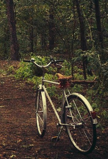
Resilience has become a particularly popular idea recently, applied to both individuals and a variety of systems, from enterprises to ecosystems.  Resilient systems are able to quickly ‘bounce back’ after a disturbance, repairing or finding new ways to accomplish important functions.  In biological systems, diversity and connectedness are important interconnected contributors to resilience.  Healthy populations are genetically diverse, and for all but the smallest organisms, these populations will range over areas that are larger than the partitions we humans choose to place on the landscape.  Where this is recognized, we can protect corridors that connect important habitats.  Like the bicycle, these corridors need to be intact to serve their function.  Removing one part of the corridor, with a residential development or tall fences around an agricultural property, pretty much eliminates the connectivity provided by the corridor.  Removing 1% of the land in a corridor can remove 100% of its function.

Like our non-human cousins, we humans also need for resources and mates.  Prior to the development of permanent settlements, humanity was generally organized into small hunter-gatherer societies.  There was normally no need for a notion of private property within these societies, as they are thought to have been largely cooperative.  Contact between these societies may have been conflictual, particularly when population densities became large enough that resources were scarce.  Technological innovations eventually enabled permanent settlement in communities large enough that kinship relations were no longer sufficient to sustain cooperation and sharing.  The simplest social structures that could maintain order in these societies relied on force.  Where monitoring and controlling the peasantry was difficult, social structures reliant on some level of mutual consent were sometimes more effective (The Decline and Rise of Democracy).  As technological and social innovations continued to emerge, various theological and philosophical justifications for the organization of society were put forward.  It was likely recognized may times over the millenia that people who are able to keep the results their effort put in more effort.  Around the 17th century, with a growing agricultural population expanding into previously uninhabited areas, the idea that when a person invested in a parcel of land, that it would be right for them to ‘own’ that land became popular in some areas (see work of John Locke).  Evidence of investment include cultivation and fencing to contain and manage livestock.  Such enclosures produced a tension with the more nomadic ‘traveller’ societies that were and continue to be present.  Within Europe there was not much remaining agriculturally productive land to be expanded into, and the ‘New World’ offered a place for people to acquire land for themselves.  The US Homestead Act and the Dominions Land Act embodied the principle of ownership through investment.  Where investment was a key justification for private property, enclosure and exclusion have also been important demonstrations of ownership, particularly in more modern times when speculating on land for potential future development or resource extraction has become common.  Therefore, in many areas, we now have large tracts of privately owned land that remains largely in its natural state, without a common recognition that this land was used by people in that natural state prior to colonization.  The rules around this private property generally grants to the property owner pretty much complete control over the use of the property, including exclusion of others from any use of the property.  However, some of the value people get from the landscape comes from the ability to travel freely across that landscape, uses that are inconsistent with the way we have implemented private property in countries like Canada, the United States and Australia.  Beaches and byways would be examples.

The iconic image of a beach includes a long stretch of sand meeting the water of a lake or ocean, with perhaps a rocky headland in the distance and maybe some footprints or somebody walking away along the sand near the water’s edge.  This setting invites us to explore, to wander down the beach, feeling the wind and the waves, and searching for those little treasures, a shell, a pretty stone, etc. that the water may reveal.  These images do not show docks, retaining walls, fences, etc. interrupting the ability of the viewer to wander the beach.  By allowing the effective enclosure of the beach, such as has happened here in Kelowna, we have destroyed its function as a connected shared space.  While technically private property only extends to the high water mark, there are very few places along the lakeshore near Kelowna where the view one has ‘invites’ one to wander down the beach.

Global News photo

Castanet.net

Like beaches, our landscape of mixed grasslands and forests blanketing an undulating geography with multiple possible viewpoints invites wandering.  However, much of the land at lower elevations is private property, fenced, with abundant ‘no trespassing’ signs.  These signs are part of what is required for an owner to show possession of the land, and it is an offence under the Trespass Act in BC to enter lands so marked, or otherwise defined by a boundary or use (Trespass Act).  This is an offense that can be prosecuted by the Crown, if it is brought to the attention of the Crown and the Crown chooses to pursue it.  It can also be pursued by lawsuit undertaken by the owner of the land.  In general, penalties for convictions are relatively light, unless damage has been done to the property, or there is blatant and willful disregard for the law.  Therefore, if one chooses to jump a fence or walk past a no trespassing sign to hike across this beautiful landscape we occupy, one could be subject to a fine or some jail time.  Exceptions exist if it is clear that the original Crown grant of the land as deeded land made allowance for passage on a road or trail, and/or if it can be demonstrated that such passage was a normal and accepted use on the land.  These are very hard to prove, and generally the owner’s right to exclude people is upheld.

When one talks to land owners about why they insist on keeping people off of their land, concerns about liability for injury are usually the first thing raised.  While the spectre of a lawsuit for a sprained toe bankrupting a small rural land owner is clearly frightening, this would be a very difficult case for the trespasser to win.  In particular, under the Occupiers Liability Act, trespassers and recreational users who are not paying a fee for access are “deemed to have willingly assumed all risks” and the owner is only liable if an injury is the result of reckless disregard or intent to do harm (Occupiers Liability Act).  The risk of losing an expensive lawsuit after an injury suffered by a trespasser therefore doesn’t seem to have much substance.

cbc.ca

The other issues land owners raise are damage to property and theft.  Given the way some people treat crown land, this would seem to be a far more serious concern.  If trespassers can be identified and the damage they have caused measured, then the owner is entitled to compensation, and further punitive damages may be awarded to discourage such trespass and damage to property.  On large undeveloped rural properties, it would be very costly for owners to secure the borders of their property, detect and identify trespassers, detect and identify the damage that those specific trespassers caused, and then pursue a legal resolution.  Consequently, many rural land owners simply accept that trespass will occur and damage will occur.  At the same time, any effort to grant more rights of passage across – or even near – such properties are strongly resisted (e.g. Okanagan Rail Trail and Eldorado Ranch).

theconversation.com

If there is a public benefit from being able to pass over or recreate on undeveloped private lands but no real practical way to detect trespassers and establish a clear causal link between specific trespassers and the damage they do, do we have the laws right?  In many northern European countries, people have rights to use private lands for passage and recreational purposes.  Such passage has a very long history, and only relatively recently has been codified into laws.  These rights also come with responsibilities that generally require that people using private land do not alter or damage the land (Wikipedia: Freedom to Roam).  Establishment of such rights in the UK was at least partly the result of a ‘mass trespass’ to highlight the growing exclusion of the public from private lands that were formerly accessible (Wikipedia: Mass trespass of Kinder Scout).  This right to roam continues to evolve, with legislated ‘codes of conduct’ establishing the responsibilities of those crossing or using private lands.

Most of the countries that emerged from what were once British colonial territories have established much stronger private property rules that render almost all unauthorized entry onto private property a criminal offense.  Is this difference a direct result of colonization and the objective of dispossessing the original human inhabitants of the land, many of whom were semi-nomadic?  Did the indigenous cultures and legal systems that were followed prior to colonization by the British embody something similar to a right to roam and an understanding that such a right embodied a responsibility to not damage the land (see Why Canadians need the ‘right to roam’)?  In British Columbia in particular, very few treaties were signed, and thus the issuance of Crown grants that created fee simple private property is of questionable legitimacy (Aboriginal Title and Private Property).  To what extent can a private property owner in BC legitimately accuse another person of trespass when the Crown grant which established the private property may not be valid?

J. Janmaat

Can we move towards a system of property law that embodies a greater freedom of public access and use that respects the land, and respects the ability of the owner to make use of that land to support their livelihoods?  The fundamental economic justification for private property is that owners will make the best use of the property they own if they are able to reap the benefits of their investments in their property.  The economic justification for limits on private property are the existence of external costs borne by society at large from uses made by the private owners.  Limiting access, where that access does not interfere with the ability to the owner to benefit from their investments is such an externality, and society is made worse off by providing private owners with such strong property rights.  Finding a system that addresses the fact that some members of the public will damage private (and public) property which fairly addresses the costs to individual owners and society at large is in the public interest.  I suggested in my last post (Licencing Recreation Use of Crown Lands) that we should be collecting fees from recreational users to help cover the cost of enforcement and of remediating damage.  Perhaps this idea needs to be extended to private land as well, with some system to help with enforcement of conduct on private lands and repair of damage where the responsible party cannot be identified.

Is it time to licence recreational use of crown lands?

We are loving our crown lands to death, particularly those crown lands closer to population centers and closer to particularly attractive destinations.  There is also a common public attitude that we can do whatever we want on crown lands, with very vocal opposition to any restrictions on what recreational activities people can engage in on crown lands.  Enforcement activities are limited, in large part due to a lack of resources for enforcement activities.  Those recreators causing the most damage are therefore unlikely to be held accountable for their actions.  What can be done?

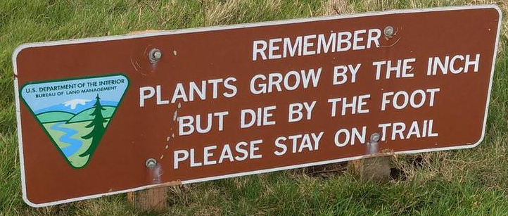
The impact a recreational user has on the land depends on the recreational activity, the sensitivity of the environment, the amount of use, and the condition of the recreational infrastructure. In popular hiking areas, hikers shortcutting trails contributes to erosion, damaging trails and the surrounding natural areas.  In sensitive habitats “plants grow by the inch and die by the foot.”  Hikers are encouraged to stay on the trails, and in some areas, such as the West Coast Trail, the number of people using the trail is also restricted.

Limiting access in some areas directs recreational activity to other areas that are not restricted.  Many of these areas, while perhaps not as iconic as the areas we have protected, are also often sensitive.  This is particularly true as our provincial population increases, the number of visitors to our province increases, and the technology we use to recreate on crown land has more environmental impact.

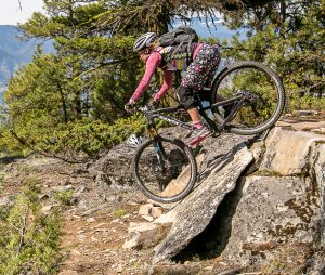
For some, spending time in nature is primarily an opportunity to connect with the natural world.  For others, it is primarily an opportunity to physically and mentally challenge oneself.  For many, it is a combination of the two.  Hikers may try to hike farther, may try conquer summits that are technically challenging or far away from regular access.  Mountain bikers may seek a challenging downhill run.  Snow mobile riders like the challenge of high marking a steep slope.  ATV riders enjoy the challenge of negotiating complicated terrain.  We enjoy the discovery of new challenges and the satisfaction of overcoming them through our personal physical abilities and our skills at handling our equipment, be that a hiking boot, a climbing rope, a mountain bike or a quad.  While the motivations for our recreational choices may not be that different, the impacts of our recreational choices are.  For every hour outdoors or every kilometer travelled, the quad rider has more impact on the outdoors than the hiker.  If we are going to ensure that all, regardless of their recreational mode of choice can continue to enjoy our crown lands, we need to accept that different modes have different impacts, and that use needs to be managed relative to these impacts.

Our neighbour to the south manages access and use of national and state lands through a system of passes and permits (Washington Trails Association).  Passes are purchased per trip or annually, providing funds for managing national and state lands.  Permits are required to access areas with use restrictions.  The need for passes and permits also provides a mechanism for educating users about their responsibilities when using these public lands.  The routine purchase of a pass is an opportunity to provide recreators with information such as this Washington DNR Brochure.

Here in BC we suffer from a lack of resources to maintain and expand camping facilities, build and repair trails, administer and regulate the activities of volunteer groups, rehabilitate areas damaged by recreational users, and enforce regulation of recreational use.  The provincial government struggles to justify devoting more resources to these activities against pressures to keep taxes low and spend more on healthcare, education, and infrastructure like roads.  Collecting fees from recreational users that are dedicated to the sustainable management of recreational use on crown land provides the potential to alleviate this resource issue.

Given the impacts of different modes of recreation on the land and the different costs of both building infrastructure and rehabilitating damage, it makes sense to have an annual feed that differs by mode.  The mode groups might be:

  1. Off highway vehicles
  2. Motorized snow vehicles
  3. Campers
  4. Mountain bikes and similar human powered modes
  5. Skiers, snow shoers, and similar human powered winter modes
  6. Equestrians and similar animal assisted modes
  7. Hikers

While catching and prosecuting the ‘bad apples’ in each of these groups is a challenge, it is fairly easy to identify the damage done by each mode.  The annual fee should be set such that there are sufficient funds to rehabilitate the damage done annually by each mode, together with funds for education, facilities construction, and maintenance and enforcement.  The province could be divided into regions, with fees reflecting the regional impact of the different recreational users.  The annual fees could then be adjusted by region, based on the damage observed.  In those areas where user groups are more effective at self-policing, annual fees would be lower.  As in Washington State, visitors to BC would also need the appropriate pass, purchased prior to recreating on crown lands.

Our province has some of the most varied and unique landscapes in Canada.  However, these landscapes have a limited capacity to recover from the impacts of our recreation.  We need the resources to effectively manage our landscapes to minimize the adverse impacts of our recreational activities so that all, present and future, continue to be able to enjoy their beauty.  An annual recreational licence could be a source of funds for addressing the management challenges and a tool for educating recreationalists about responsible recreation with their preferred modes.  Perhaps it is time for such a licence system in BC.

Our Similarities and Differences

Several years ago I supervised a research project that sought to measure how much central Okanagan residents were willing to pay to protect several different local environmental resources.  A couple of years ago I presented a summary of the results to the Environmental Advisory Committee (EAC) of the Regional District of Central Okanagan (RDCO).  I was strongly encouraged to develop some material that made the results easily available to people involved with local government.  Assorted obstacles have finally been overcome, and there are now three fact sheets and a technical report available that I hope is consistent with the desires expressed by the EAC.

  1. Heterogeneity Fact Sheet.
  2. Deliberation Fact Sheet.
  3. Social Network Fact Sheet.
  4. So You Say You Value the Environment: Conversations, Networks, and Stated Values.

The Research Project

The Choice Experiment

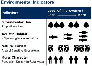
The core of this research project was a choice experiment.  In a choice experiment, people are given sets of choices to compare.  In this experiment, the choices were between different ways the Central Okanagan could be in thirty years, where those futures were described using four indicators:

  1. Share of total water use coming from groundwater,
    With surface sources largely tapped out, we saw increasing the share of water use from groundwater as increasing the total amount of water being used.
  2. Kokanee salmon spawning returns,
    Kokanee are a landlocked salmon species that spawns in tributary creeks and some areas of lakeshore.  Land use change threatens the habitat necessary for the Kokanee.
  3. Square kilometers of natural habitat lost,
    Much of the most valuable natural habitat is at lower elevations, and privately owned.  With continuing development, such land continues to be lost.
  4. Rural population density.
    Rural areas in the Okanagan reflect the agricultural heritage of the region.  Increasing development in these areas is changing their character. 

Survey participants were offered six sets of three choices, where each set included a ‘status quo’, reflecting our opinion about how these indicators will change without any further intervention, and two alternatives that reflected improvement in at least one indicator.  These improvements need to be paid for, and each of these alternatives had an associated increase in property taxes to pay for it.

The Deliberation Experiment

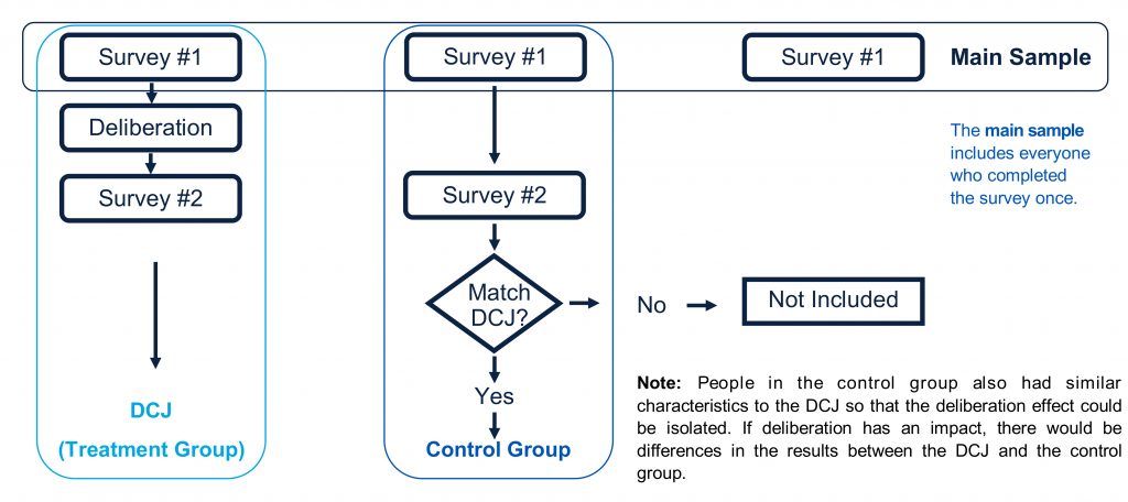
We are social beings, and our opinions and values are likely shaped by our interactions with others.  One way we chose to include this in our experiment was with a deliberation exercise.  Each participant in the original survey was invited to partake in a pair of sessions where they would engage with a group of other participants in an exercise inspired by the issues at the heart of the choice experiment.  After the deliberation, all participants in the survey, whether they were part of the deliberation again, were asked to complete a second, shorter version of the same choice experiment they had originally completed.  This allowed us to see if deliberation changed how people responded to the choice experiment.

social network measures

Where deliberation gave people an opportunity to talk with others who completed the survey about survey issues, people may have other circles where they talk about development and the environment in the Okanagan.  We added a set of questions to the first choice experiment that collected information about the network that respondents engaged with about development and environment issues.  We then included measures that reflected aspects of these networks in our statistical analysis of the data.

Results

heterogeneity

One set of results are summarized in our Heterogeneity Fact Sheet.  The fact sheet explores some aspects of the analysis and implications.  One important result is that people are quite different in how much they are willing to pay for improvements in the future environmental situation in the central Okanagan.

One way to look at this variation between people is by dividing people into groups that are somewhat similar.  When we group people into five such groups, we find a few striking differences between the groups.  For example, peoples perspective on whether the benefits of development had, on balance, outweighed the damage to the environment distinguished two groups that we labeled as ‘pessimist’ from the other three.  Another thing that stood out was the fact that most people substantially overestimated the importance of tourism as an employer in the central Okanagan.

Overall, the survey results enable us to say that for those who participated, there was broad agreement that protecting natural habitats and promoting aquatic health was important.  There was less agreement that it would be good to limit the growth of groundwater use and that keeping population densities in rural areas at their current level is a worthwhile goal.

deliberation

Our second fact sheet describes our Deliberation Experiment Results.  Three results stood out.

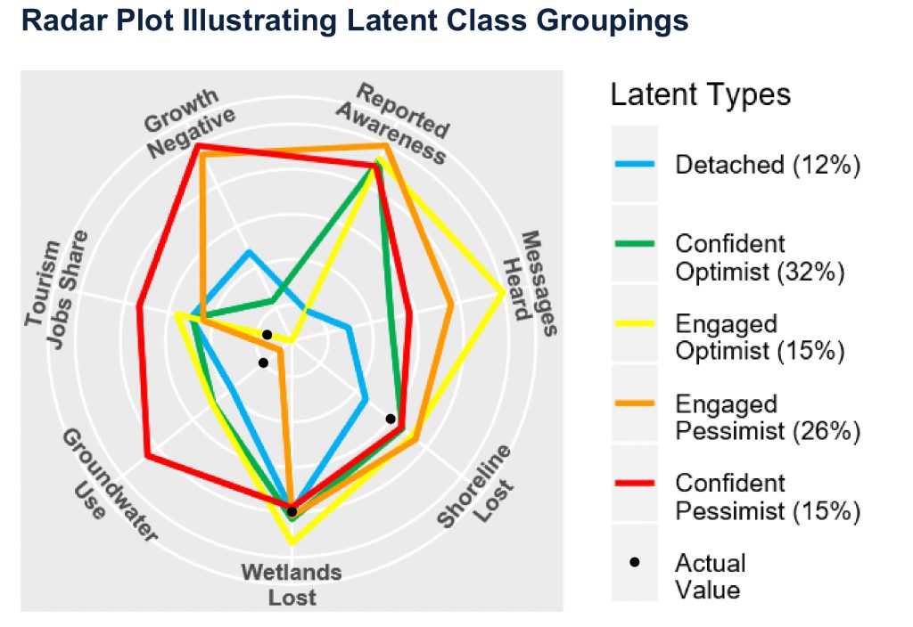
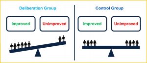
First, people who volunteered to be part of the deliberations seemed to be more concerned about the environment in the Okanagan than the average for the entire sample.

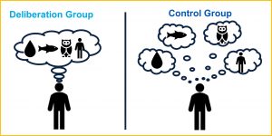
Second, people in the deliberation groups seemed to think about the environmental indicators in a more integrated way.  They thought about the relationship between the environmental indicators.

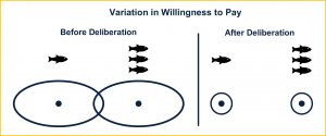
Third, people who participated in the deliberations had less variation between themselves in how much they were willing to pay to see improvements in the environmental indicators.  Talking together lead people’s perspectives to converge.

social networks

Our third fact sheet describes our Social Network Analysis.  We found that social networks matter!  Survey participants with ‘tighter’ networks, networks where the people involved were more connected to each other, were more likely to make choices in the choice experiment that would result in better future environmental outcomes.

Implications

  1. There is a lot of variation in the amount people are willing to pay to see improvements in the environmental indicators we used.  Any approach we choose will therefore have critics who say it has not gone far enough and others who say it has gone too far.
  2. There is broad agreement that protecting natural areas and enhancing aquatic health is worthy of spending money on.  However, there is a wide variation in the amount people think should be spent.
  3. Engaging people in conversations about the environmental costs of development in the Okanagan tends to build a greater consensus around the desired future.
  4. Developing relationships within which people talk about the impact of development on the Okanagan environment may increase the amount people are willing to pay to protect that environment.

The Contributions of Irrigation

I recently had the opportunity to give a presentation to the BC Water Supply Association, considering the economic impact of irrigation in the Okanagan.  I subsequently added to the presentation and presented it at a professional development event for the BC Institute of Agrologists.

Adobe PDF Presentation Slides

https://www.tourismkelowna.com/things-to-do/wineries/

We do not know the economic impacts of irrigation in the Okanagan.  A 2017 study commissioned by the Canadian Vintners Association, the Winery and Grower Alliance of Ontario, British Columbia Wine Institute and the Winery Association of Nova Scotia reports that the wine and grape industry has a $9 billion impact on the Canadian economy, and a $2.8 billion impact on the BC economy.  How much of this $2.8 billion would occur if there were no irrigation in the Okanagan?  We don’t know.

Canada’s Wine Economy – Ripe, Robust, Remarkable

https://www.vernonmorningstar.com/

As part of the Kelowna airport expansion plan, SNC Lavalin was commissioned to estimate the economic impact of the airport.  The airport is estimated to contribute $599 million in total activity to the economy, and catalyze $190 million in tourism activity.  This is estimated to be $345 million in Gross Domestic Product (GDP) impact from airport activities, and $90 million in GDP impact for the catalyzed tourism activity.  How much of this activity is related to irrigated agriculture?  How many business trips? how much agricultural products as air cargo?  How much of the tourism attractiveness is related to wineries?  We can probably measure the direct expenditure shares, but how about indirect effects?

Airport Master Plan: Economic Impacts

What are we trying to measure when we talk about economic impacts? Irrigation enables farmers to get more yield and/or grow a higher value crop.  All of that extra sales goes somewhere.  Some of it leaves the Okanagan, such as buying tractor parts from the US.  Some of it stays here, such as the wages paid to the mechanic who used those parts to fix the tractor.  Some of the wages earned by the mechanic might be spent on oranges imported from China, while some is spent on locally grown peaches.  Those peaches and oranges were bought at a grocery store, and part of the price paid for that fruit are wages for the person stocking the shelves.  Some of their income will be spent locally, more economic activity again.  And so on, and so on, …  In this way, the boost in revenue that irrigation enables on the farm swirls around through the local economy, generating more economic activity.  How much more?  That depends on knowing how quickly those extra revenues leak out of the area.

I don’t know of a good recent estimate of the economic impact of irrigation in the Okanagan.  Statistics Canada reports that there are 186,234 hectares of farmland in the three regional districts that cover the Okanagan, 24,294 of those being irrigated.  The reported total gross farm receipts for these same three regional districts is $431,027,968.  We can play around with these numbers a little bit to get an idea of what the economic impact might be.  To do that, we do need to make a couple of assumptions.  First, how much more productive is irrigated farmland in the Okanagan, relative to land without irrigation?  To get some ranges, I’m going to try 5:1, 10:1 and 20:1.  This probably varies around the Okanagan, as you can’t grow the same things in Armstrong that you can in Osoyoos.  These numbers are a place to start.  The other thing we need is a multiplier that accounts for the local economic impacts of the extra farm revenues.  The wine and grape industry study reports $9.04 billion of total impact from $1.24 billion of direct sales, a multiplier of 7.3.  The Kelowna Airport study $599 million in total impact from $336 in direct sales, a multiplier of 1.8.  For this back of the envelope calculation, I’ll assume that each extra dollar of farm revenue generates two extra dollars of economic activity in the Okanagan.

Revenue Ratio 5:1 10:1 20:1
Revenue / Acre
Irrigation 7,604 10,646 13,307
Dryland 1,521 1,065 665
Difference 10,460 14,602 17,525
Without Irrigation
Lost farm revenue 147,791,446 232,766,600 307,116,908
Lost GDP (3:1) 443,374,339 698,299,801 921,350,725

This quick, back of the envelope calculation suggests that irrigation in the Okanagan contributes, on the low end, almost half a billion dollars to the Okanagan economy, and on the high end closing in on a billion dollars.

This impact doesn’t include the value of the landscape irrigated agriculture in the Okanagan provides.  That landscape has value.  It attracts new immigrants to this valley, and draws the tourists.  Much of this benefit is not connected in any way to farm revenues, and missed by the back of the envelope calculations above.  How big is it?  We don’t know.

Protecting the agriculture we have in the Okanagan and taking advantage of new agricultural opportunities created by the changing climate will require investment in irrigation.  The benefits of this investment extend beyond the farm gate.  How should we share the costs of making these investments?

Love for the land.

For the children and the flowers
Are my sisters and my brothers
Their laughter and their loveliness
Could clear a cloudy day

(John Denver, Rhymes and Reasons)

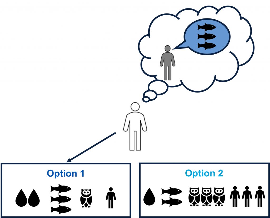
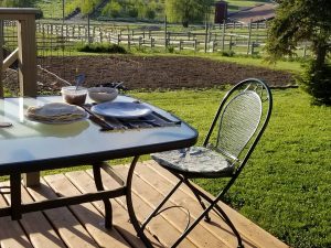
I spent the Mother’s Day weekend with my mom, although she passed away almost ten years ago.  One way I keep her memory alive is by cooking special breakfasts – crepes this day – sometimes for myself, and particularly when I have the chance to do so for family.  The other is to plant a vegetable garden.

There is no good financial reason for me to grow vegetables.  The time I have spent growing food could have gone towards furthering my career, and the resultant increase in my salary would more than pay for what it would cost me to buy the food I grow.  However, over the nine years I have lived on this property and tried to grow something, I have learned about this land.  I have learned that when the balsam root and saskatoon blossoms are passing their peak, the soil temperature is about right for planting.  I have learned that there is a narrow window of soil moisture during which Glenmore clay can be easily worked.  I have learned that after one season there won’t be much organic material left in the garden and the remaining clay will set up like concrete when baked in the sun.  I have learned that carrots don’t grow well in this clay, and neither do acid loving blue berries.  I have learned many different things, some of which are more of a feeling than a fact I can easily describe.

Source: Three West Security

My ruminations on these matters have been particularly strong since my colleague, Dr. Ross Hickey, suggested that getting rid of the Agricultural Land Reserve (ALR) would help address the high cost of housing here in Kelowna (Let’s Develop the ALR).  There is a beautifully simple logic to his argument.  The price of housing is high because supply isn’t expanding fast enough to keep up with the growth in the demand for housing.  The ALR makes some land unavailable for housing, and some of this land is ideally located and relatively cheap to service.  If land availability is the restriction preventing an increase in the housing stock, then getting rid of the ALR will lead to an increase in the rate at which new housing is build and thereby bring down the price.  If land is simply a physical space which can be used for a variety of purposes – housing, transportation, parks, wild spaces, food production, … – then it follows that each piece of land should be put to that use which generates the greatest value for society.  To the extent that the market does the best job possible of reflecting these values, an unrestricted land market should yield the best pattern of land use.

Source: Vancouver Courier

One place to challenge the effectiveness of a free land market is to consider the variety of services that the land provides which are not captured by that market.  Viewscapes, open spaces, natural habitat, etc. are such services.  These services have value, and in principle if we could measure the value of these services, we could put in place policies, such as taxing particular land use activities and subsidizing others, to adjust the land use pattern that would prevail with a free land market.  Many economists have been arguing for such an approach and seeking to improve methods of valuing these services.  With such measurements, we can calculate the return paid by the land for one purpose, and thereby determine if it should be kept as ‘natural capital’ or developed for other purposes.  However, not everyone buys the idea that putting a price on nature can help save it.

In a recent column George Monboit (“The UK government wants to put a price on nature – but that will destroy it“) strongly rejects the idea of valuing the services of nature.  He argues that determining the value of nature based on the price people are willing to pay for the services nature provides diminishes nature having value in its own right, having ‘intrinsic’ value.  He concludes with

This approach is morally wrong, intellectually vacuous, emotionally alienating and self-defeating.

Those of us who are motivated by love for the living planet should not hesitate to say so. Never underestimate the power of intrinsic values. They inspire every struggle for a better world.

Within economics, intrinsic value, the value a thing has in itself, is recognized for humans.  Economists have many times been asked to calculate the value of investments that change the probability of someone dying, investments such as roadway design and safety regulations.  Initially, the value of life was based on lifetime earnings.  However, it didn’t take long to see the moral issue here, that people who were no longer making a productive contribution have a zero or even negative value.  Currently, economists try to measure what people themselves are paying to reduce their probability of death.  Measuring what people are willing to pay to reduce their own risk exposure is, in effect, asking what their intrinsic value is.  However, this idea has not moved much beyond valuing mortality risk for people.  Can it be extended?

Source: Okanagan College Clean the Creek Campaign

We have learned that the amount of knowledge people have about the environment and their attitudes towards the environment are at best only weakly related to environmental behavior change (Kollmuss and Agyeman, 2002).  Some work is showing that empathy for the environment can motivate change (e.g. Berenguer, 2007 and work described in Greater Good Magazine).  Empathy is the ability to feel what another is feeling, in response to knowing the situation they are in.  Empathy is correlated with compassion, and compassion with making choices for the well being of others.  And this is strongest when there is a relationship.  Monboit’s critique points out that when we value the natural world based on the services it provides us, we undermine the relationship that fosters empathy.  His appeal to “Those of us who are motivated by love for the living planet …” clearly emphasizes the idea of a relationship with that living environment.

Economic efficiency occurs when all resources are put to their most valuable use, and in a dynamic economy, these resources should be as mobile as possible.  Innovation is fostered by enabling those who develop new products that are valued in the market to capture a large share of the profits.  Those who are unable or unwilling to move to the jobs and/or to be innovators are ‘left behind’.  This system discourages attachment to ones local community and environment.  Best to maintain an extensive network that can facilitate moving, if that is required, rather than in building strong local connections that will be of limited value after a move.  Best not to invest too much in a relationship with the local environment, as that investment is lost if one moves.

How, with an economic system that rewards flexibility, mobility and innovation can we create a space for people to have a relationship with the environment that builds empathy and compassion, and thereby motivates people to care for that environment?  Our economic system has done a tremendous job of stimulating technical progress and raising the living standard of many people around the world.  However, this progress has occurred while the environment has been treated primarily as a ‘factor of production’, providing resources and assimilating waste.  How can we recognize the intrinsic value of the living systems we share the planet with in the same way we do for the other humans we share the planet with?  Recognizing (although not necessarily respecting) the intrinsic value of all humans occurred relatively recently in the history of our species.  Through much of that history in many societies slavery was acceptable and women were treated little better than property.  Now, in most societies, all people have basic legal protections.  Do we similarly need to have basic legal protections for the natural world?

Source: Sikhnet

The natural world, be that a species or an ecosystem, cannot express its intrinsic value through market activities the way humans can.  We cannot therefore observe such choices and impute the value that a species or ecosystem is willing to pay to protect its functionality.  Perhaps our moral duty to the natural world is to protect its functionality.  If we have an economic system that makes it difficult for people to develop empathetic, compassionate relationships with the land, maybe the land has to be given rights.  Perhaps policies like the ALR are imperfect ways to provide the land with some rights.  If we lack the empathy and compassion to treat women and members of minority groups with respect, then we are compelled to provide at least some basic respect by the law.  Is it time to give the natural world this same type of protection?

  • Kollmuss, Anja, and Julian Agyeman. “Mind the gap: why do people act environmentally and what are the barriers to pro-environmental behavior?.” Environmental education research 8.3 (2002): 239-260.
  • Berenguer, Jaime. “The effect of empathy in proenvironmental attitudes and behaviors.” Environment and Behavior 39.2 (2007): 269-283.