What does the world look like when you map it using data? Social geographer Danny Dorling invites us to see the world anew, with his captivating and insightful maps that show Earth as it truly is — a connected, ever-changing and fascinating place in which we all belong. You’ll never look at a map the same way again.
All posts by samaneh gharehdaghi mollahajloo
 Follow
38 Maps They Didn’t Teach You At School
Let’s visit the link below. You can find many interesting subjects of these maps and they may be helpful to you to extend your imagination beyond the regular topics of mapping.
http://www.boredpanda.com/interesting-maps/
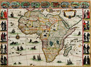
‘Africae novo’ map
- Its geographic representation is quite accurate. The artistry of this map is breathtaking. The vivid colors, the artwork around the border, the fanciful creatures scattered over land and sea, all add to the sense that this was as much a work of art as a map.
- The continent of Africa portrayed on the map is actually a close illustration of the scale and shape of the continent.
- The map reflects European exploration bias.
Think about it: How much can we trust the information of the map when we know like most cartographers of the time, he was not an explorer himself and he drew his maps from the accounts of explorers, traders, and travellers?
http://chnm.gmu.edu/worldhistorysources/unpacking/mapsanalysis.html#