Justifying the Buffer Size of the Projects Overlapping Existing Freshwater Wetlands
Huckleberry Copper / Silver / Molybdenum Mine
Main zone optimization and extension of Huckleberry mine life by 7 years will include $119 million for upgrades and $82 million for dam construction. Project has received certification under the Environmental Assessment Act.
Surface soils and groundwater in the vicinity of mines can have severe contamination, the extent of which is influenced by a variety of factors including but not limited to topology, precipitation, contamination composition, and substrate composition (Feng et al., 2021). Risks associated with mine tailings are extensive, and include acid rock drainage, secondary mineral sedimentation, water-table contamination, biodiversity loss, land erosion, and a multitude of other environmental effects (García-Giménez et al., 2017). In addition to the direct loss of wetlands via excavation for expansion, the presence of waste rock can lead to the leaching of chemicals into soil and groundwater, contaminating surrounding watersheds and acidifying the water (Carsten, 2014). Since wetlands have high organic matter content and readily take up metals, they are particularly susceptible to contaminants (Carsten, 2014). Although the presence of tailings does not necessarily guarantee the contamination of surrounding soils, there is still considerable environmental threat due to the potentially high concentrations of toxic trace elements (García-Giménez et al., 2017).
According to the study, “A Modelling Study of a Buffer Zone in Abating Heavy Metal Contamination from a Gold Mine of Hainan Province in Nearby Agricultural Area,” in which the spatial distribution of various heavy metal concentrations around a mine were assessed, the “As and Zn concentrations decreased from the mine area, while the lowermost values are recorded at 800 m radius” (Feng et al., 2021). Additionally, “the Cu and Cr concentrations are highest at 0 m and are the lowest at 800 m” (Feng et al., 2021). However, in the study, “Mine tailings influencing soil contamination by potentially toxic elements” in which mine tailings were measured for toxic elements and the geochemical impact in surrounding soils, “a total of 17 surface soil samples were collected from both mixed sulfide mine tailings sites and unmined soils, within a radius of 1900 m from the mine entrance” with all samples having some degree of contamination (García-Giménez et al., 2017). Both of these studies illustrate the variability of soil contamination around mines, each mine having unique groundwater migration, precipitation patterns, and other environmental factors influencing soil contamination. Based on these findings, this project will take a conservative approach by implementing a 2000 meter buffer around the perimeter of the Huckleberry mine expansion project to quantify the loss of existing and/or suitable wetland habitat. This buffer resulted in a predicted 51,850,077 m² or 52 km² of wetland loss.
Willow Beach Condominiums
Situated on a former campground, this Willow Beach development was initially planned to be a large, mixed-use community, with a range of residential and commercial uses on the property. Residential dwellings would range from single-family homes to mixed-use mid-rise condominium complexes with small businesses underneath. The developer’s goal is to create a real community mixing with nature with preliminary drawings proposing artificial channels winding through the land, granting access to the lake from many of the homes (Osoyoos Times, 2013). The implications of the developer’s vision of creating a real community will, unfortunately, affect the degraded wetland community, damaging the ecological capacity of this ecosystem.
Figure 3. Context map for the proposed area of Willow Beach Condominiums.
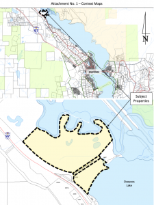
Note. Retrieved from https://www.rdos.bc.ca/assets/PLANNING/AreaA/2021/003-ZONE/20210614-RPT-APC-Report.pdf
This large-scale project has been scaled down to 70-units following restrictions surrounding existing infrastructure and zoning law limits. An Administrative Report from the Osoyoos Regional District was created this year to “facilitate a 70-lot subdivision and creation of conservation and dedicated park areas”(Newell, 2021). Fortunately, a focus on conservation and maintaining undeveloped natural green spaces on more environmentally sensitive areas to the northeast will decrease the extent of the development’s effects on wetland territory.
This development project will have a combined land of 29.7 ha (297 000 m²). However, the proposed development will take up less than half of the total land. Based on this picture from the Administrative Report, we believe that a 30 m buffer should be made around the lot that is being developed. The Ministry of Environment of BC identifies that a 30 m buffer between development and wetlands is the ideal range (“Wetland Ways”, 2009) and this can represent the extent that could impede on wetlands territory. This buffer resulted in a predicted 141,409 m² loss in wetlands.
Figure 4. Land use site plan for Willow Beach Condominiums.
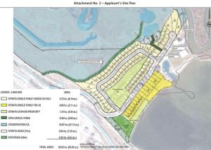
Note. Retrieved from https://www.rdos.bc.ca/assets/PLANNING/AreaA/2021/003-ZONE/20210614-RPT-APC-Report.pdf
Red Willow Wind Farm
The Red Willow Wind Farm is a proposed project site located approximately 40 kilometers southeast of Tumbler Ridge, and 30 kilometers from the BC-Alberta border, within the Peace River Regional District. The wind turbine capacity will range between 2-3 MW for each of up to 80 wind turbines, depending on the turbine model selected (Cassel, 2015). The project will also include new access roads and a 230kv transmission line that will connect to the Quintette Substation.
The Red Willow Wind Project will help achieve provincial goals set out in the 2007 British Columbia Clean Energy Plan by providing safe, reliable, and clean electricity. The estimated capital cost of the project is C$480 million (Government of BC, 2015). It is anticipated that the energy generated by the project will be sold to BC Hydro under an EPA issued through a future Clean Power Call. An environmental assessment certificate must be obtained before any work can be undertaken on the proposed Project.
According to Boralex’s Project Description, “the project area has the potential to support various wildlife species, including the following:
- Ungulates, e.g., caribou (Rangifer tarandus), mountain goat (Oreamnos americanus), moose
- (Alces alces), elk (Cervus elaphus), and mule deer (Odocoileus hemionus hemionus)
- Grizzly bear (Ursus arctos)
- Fur-bearing species, e.g., fisher (Pekania pennanti), wolverine (Gulo gulo luscus)
- Bats
- Birds, e.g., breeding and migrating passerines, marsh birds, and raptors” (Hemmera Envirochem Inc., 2015).
While the project description mentions the support of bird species, a buffer zone of 1 km is needed. In a study conducted by Li et al. (2020) on striving for balance in wind energy development and waterbird conservation, it was concluded that a buffer of 800-1300m from the project could be defined as a buffer to protect waterbirds. 1000 m buffer was chosen as in the study, the wind farm contained a dyke that surrounded the perimeter. In the case of the Red Willow Wind Farm, there is not a dyke, therefore, that distance is reduced from the maximum suggested area. This buffer resulted in a predicted 461,645,328 m² or 462 km² of wetland loss. The total predicted area of wetland loss from these three projects is 513, 636, 814 m², or 513.6 km².
Figure 5. Project area overview map of Red Willow Wind Project including proposed substation, interconnection points, turbine area and collector corridor used to create outline and buffer for the project.
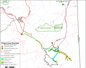
Note. Retrieved from https://www.westmo.org/sites/default/files/event-files/Red%20Willow%20Wind%20Project%20Information%20042915.pdf