Before we could begin our computational analysis we needed to research which factors were important when considering avalanche formation. An avalanche is a rapid, sudden release of snow which travels unchannelized downhill (National Avalanche Center, 2016) either as a slab avalanche or a sluff fall. Slab avalanches occur when a coherent, dense block of snow is released and begins to slide on the weak plane of snow. Sliding occurs when the tensile strength of the snowpack is exceeded, causing a failure and release of a coherent slab. Slab avalanches are the most dangerous type of avalanche, therefore factors which lead to slab avalanches were the main factors considered during this project. These variables were:
- Elevation
- Slope Angle
- Slope Aspect
- Slope Curvature
- Wind Speed
Our project began by obtaining the DEM of the study area we were interested in examining. Unfortunately, the area surrounding Whistler was directly on the border of two different DEMs. We were forced to create a mosaic dataset, this joined the DEM layers into one large raster onto which we drew a polygon of our study area. Next we were able to clip the BC wind data and road line data obtained from the geography database to the study area. Once this was done the Extract by mask tool was used resulting in a DEM of the study area that we had chosen. The final piece of data we used was a layer of BC lakes that was also obtained from the geography database and subsequently clipped to the study area.
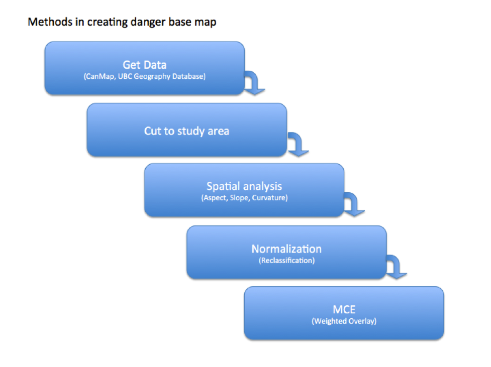
The next step was to calculate the slope, aspect and curvature of our study area. This was done using a spatial analysis tool called surface, which created new layers of each variable. The final step before normalizing the data was to convert the BC wind data to a raster layer. This next section will examine each variable in greater detail and will explain how we normalized the data to a total of 100 in preparation for the multi-criteria evaluation (MCE). The graph below is a visual representation of the steps that were taken in creating our maps.
Elevation: The elevation influences the snowline as well as the vegetation present. The coast mountains are quite warm due to the proximity to the pacific ocean, therefore the snowline in the study area was set at 650m, as below that there is not enough snow to allow for avalanche formation. From 650m to 1750m (Riegner, 2002) is the below alpine snowpack, meaning there are trees which provide anchoring points for the snowpack which reduce avalanche danger. Above 1750m is above the tree-line and there is very little vegetation to provide anchoring of the snowpack. So any elevation above 1750m was considered to be the most dangerous.
| Elevation (Meters) | Danger Classification | Weight Assignment |
| 0-650 | No Danger | 0 |
| 650-1750 | Slight Danger | 20 |
| 1750+ | High Danger | 80 |
Slope Angle: Slab avalanches are considered to be the most hazardous type of slide and they’re optimal sliding angle is 38 degrees (McClung, 2013). Much above 40 degrees and the slope is considered to be self-sluffing, meaning it is too steep to form a snowpack deep enough to build up large slabs. A 30-35 degree slope could present moderate danger, while slopes with an angle less than 30 are not considered to pose much of a threat to backcountry users.
| Slope Angle (o) | Danger Classification | Weight Assignment |
| 0-25 | Low Danger | 4 |
| 25-30 | Slight Danger | 10 |
| 30-35 | Moderate Danger | 25 |
| 35-40 | High Danger | 40 |
| 40-48 | Slight Danger | 15 |
| Over 48 | Low Danger | 6 |
Slope Aspect: Two separate scenarios were considered during the normalization of the slope’s aspect. During the winter the northerly and eastern slopes are more dangerous, as very little of the Sun’s energy reaches these slopes. Cooler temperatures allow for the formation of thick ice layers, which create weak interfacing layers leading to optimal sliding surfaces (National Avalanche Center, 2016). On the other hand during the spring months the southern and western slopes are the most susceptible to sliding. This is due to the Sun’s energy which is able to melt the snow creating the conditions needed for wet slide avalanches.
Winter Aspect Classification:
| Aspect (Degrees) | Danger Classification | Weight Assignment |
| 315 – 45 | Most Dangerous | 50 |
| 45 – 135 | Moderate Danger | 30 |
| 135 – 225 | Low Danger | 5 |
| 225 – 315 | Slight Danger | 15 |
Spring Aspect Classification:
| Aspect (Degrees | Danger Classification | Weight Assignment |
| 315 – 45 | Low Danger | 5 |
| 45 – 135 | Slight Danger | 15 |
| 135 – 225 | Most Dangerous | 50 |
| 225 – 315 | Moderate Danger | 30 |
Slope Curvature: The curvature of the slope influences the type of stress applied on the snowpack. A convex surface will apply a tensile stress on the snowpack (National Avalanche Center, 2016) which promotes the formation of a crown and the release of a slab avalanche. A concave slope reduces the tensile stress which will slightly increase the strength of the snowpack. Flat slopes were still given a moderate danger classification because they do not hinder the formation of slab avalanches.
| Slope Curvature | Danger Classification | Weight Assignment |
| Convex | High Danger | 60 |
| Flat | Moderate Danger | 30 |
| Concave | Slight Danger | 10 |
Wind Speed: In mountainous regions wind data can be problematic as it is very dynamic and inconsistent. Because of this, we used the average wind speed as an influence on avalanche formation. This layer only contained wind speeds without vectors meaning slope loading via wind could not be considered. Although there was no direction to the wind, regions with high wind speeds could still be considered dangerous. High winds are more likely to form slab avalanches because they increase the density of the snowpack creating coherent slabs (McClung, 2006). As wind speed is increased, the probability of slab avalanche formation also increases.
| Wind speed (m/s) | Danger Classification | Weight assignment |
| 1.94-2.85 | Least Danger | 5 |
| 2.85-3.76 | Little Danger | 10 |
| 3.76-4.67 | Moderate Danger | 17 |
| 4.67-5.58 | High Danger | 28 |
| 5.58-6.48 | Most Danger | 40 |