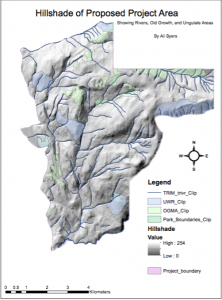
This is a map of a proposed ski resort just north of Squamish near Garibaldi Park. I chose to include the elevation profile, areas of old growth forest, mammal habitat reach, and river distribution. While this map looks relatively simple, it encompasses two weeks of work. It illustrates that areas that need to be taken into account when planning a project, but to me it shows how cartography is not something to be underestimated. This map is far from perfect and you can see that I’m still learning. However, it is a vast improvement from the first map I made. It makes me proud to look at this map and know that I made it. I also like knowing that there’s lots of room for visible growth in this discipline.