The Macmillan School Atlas 3rd Edition is a hardcover bound atlas suitable for elementary and middle school students. It features maps of the world, but focuses specifically on the western world, giving more detailed maps and additional information about average temperatures, populations, natural resources, and peoples. At the beginning of the text, there is information for students about mapping, as well as general information about the globe such as hemispheres, latitude and longitude and the turning of the planet.
Our world is changing at an alarming rate so it is quite difficult to keep geographical sources current. In fact, Riedling suggests that due to this rate of change, online resources are sometimes preferable. “Electronic geographic sources are becoming a vitally important part of school library media reference resources. These sources serve a multitude of valuable functions, are typically user friendly, and are remarkably current” (Riedling 80). While it is important to use online resources for their currency, it is equally important for us, as teacher librarians, to provide multiple sources, including print. Maps and atlases are visually appealing and many students enjoy perusing these and actually prefer them to electronic sources. All atlases are not created equal, however.
According to Riedling, “geographic sources may be evaluated using many of the same criteria as other reference sources; however, there are several additional points to consider. Because these materials depend on graphic arts and mathematics as well, further issues should be noted regarding evaluation and selection. The basic criteria to be considered when evaluating geographic resources include publisher (authority), scale, currency, indexing, and format” (Riedling 80).

Source: Riedling, Ann et al. Reference Skills for the School Librarian: Tools and Tips 3rd edition. Linworth, 2013.
In evaluating the Macmillan Student Atlas 3rd edition, as it was already a part of the school library collection, it was important to look, not only at evaluation criteria, but at criteria for weeding as well. The weeding criteria from which I took inspiration was the MUSTY criteria, as found in the table below
Source: Dickinson, Gail. Crying over Spilled Milk. Library Media Connection 23 (7), 2005.
Considering both these tables, I created my own rubric which includes both evaluation and weeding criteria in order to determine if the Macmillan School Atlas 3rd edition should be pulled from the library shelves.

The Macmillan School Atlas 3rd edition would have been a very good resource when it was published in 1992, but, as previously mentioned, our world is changing so quickly that geographical sources become outdated very quickly.
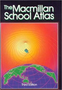
Source: Daly, Ronald. The Macmillan School Atlas. Toronto: Gage Educational Publishing Company, 1992.
The book itself is in relatively good shape, despite its age, which leads me to wonder how often it has been used over the years. The publisher – Macmillan – is a reputable source for reference books, and is well-known in education circles. The scale of the maps are clear and appropriate throughout the text. There are several types of indexes, including a gazetteer, and the layout includes a detailed table of contents. Information is easy to locate and the information pertains very well to the K-6 curriculum of the school in which it is found as it focuses more on Canada than other parts of the world. The issue with this book is its currency. According to Riedling, “a five year-old atlas is considered historical” (Riedling 80). When analyzing this text, there were several inaccuracies due simply to the age of the material. For example, the territory of Nunavut had not been formed at the time of publication.

Source: Daly, Ronald. The Macmillan School Atlas. Toronto: Gage Educational Publishing Company, 1992.
The text also has information about city populations and demographics which is quite different some 28 years later.

Source: Daly, Ronald. The Macmillan School Atlas. Toronto: Gage Educational Publishing Company, 1992.

Source: Daly, Ronald. The Macmillan School Atlas. Toronto: Gage Educational Publishing Company, 1992.
When a geographical resource is older than five years, unless for historical purposes, it is considered outdated and must be weeded from the collection. Also – and perhaps more importantly – if the resource is no longer accurate and spreads misinformation, it must also be weeded. In her article “Crying over Spilled Milk,” Gail Dickinson likens keeping ineffective resources to keeping spoiled milk. A summary of this idea is outlined in the table below. 
Source: Dickinson, Gail. Crying over Spilled Milk. Library Media Connection 23 (7), 2005.
It is for these reasons that I determined that the Macmillan School Atlas must be removed from the school library collection.
After a thorough search for a replacement resource, I decided upon the National Geographic Kids Student World Atlas 5th edition. While an argument can be made to offer online resources for the sake of currency, it is important to offer many types of resources to our students. In fact, “often electronic and print geographic materials complement each other” (Riedling 80).
This particular text has a mapmaker website that allows students and teachers to customize maps to suit their lessons at mapmaker.nationalgeographic.org.
This text is visually appealing with eye-catching graphics both on the cover and throughout the text. It is published by National Geographic which is not only a reputable resource for all things geography and cartography, but it also is a name recognized and enjoyed by students. The bright yellow band around the front cover is familiar to many students and will likely draw students to this particular text. The scale used throughout the atlas is effective and consistent and there is a conversion chart included at the back of the book. It has several indexes as well including a place-name index, a thematic index and a glossary of terms. It features a detailed table of contents and a user-friendly layout which allows for ease of access to information.

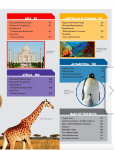
Source: penguinrandomhouse.ca
The National Geographic Kids Student World Atlas 5th edition connects to the curriculum as it provides detailed information about Canada as well as the rest of the world. There is not as detailed a focus on Canada as with the Macmillan atlas, but as a world atlas, it is effective. It covers a broad range of information for each continent and gives equal focus to each. For more specific information about particular countries, such as Canada, one must look to other sources. There are Canadian atlases available as well in the library so the need to have details on this particular part of the curriculum is not necessary. As does the Macmillan, this text also provides map reading information as well as information about the planet earth itself at the beginning of the book.
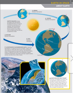

Source: penguinrandomhouse.ca
Upon choosing the text, I sourced out pricing from various vendors. One of the options available from several vendors was that of library binding, in addition to traditional hardcover and softcover. Although the quality is not ideal, the following videos were helpful in demonstrating the differences between library binding and other types of binding.
Source: www.youtube.com/watch?v=VSsk9RnaJhc
Source: www.youtube.com/watch?v=40LpyWoS_20
Essentially, library bound books have a textured hardcover (as opposed to glossy), thicker pages and a more durable binding to withstand heavy use.
I decided on Book Outlet Canada as the vendor from which I would purchase the National Geographic Kids Student Atlas 5th edition. It is available for $17.29 for the library binding edition, which is the better choice for schools and there is free shipping for orders over $45. Book Outlet Canada is an outlet store that purchases overstocked items from vendors and then sells them for a discounted price. The website states that some of the texts may have a small dot or a line on the edge of the book which I deemed inconsequential as it does not affect the quality of the resource itself.
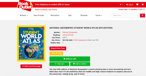
Source: www.bookoutlet.com
Ultimately, while I believe that the Macmillan School Atlas 3rd edition was an excellent geographical resource at the time of its publication, it has become obsolete in its age as it contains information that is no longer true and terms that are no longer acceptable (such as Canadian Aboriginal peoples being referred to as “Indians.”). In my view, an effective replacement would be the National Geographic Kids Student World Atlas 5th edition as it is a more current, useful and graphically engaging text for students of all ages.
Bibliography:
Daly, Ronald. The Macmillan School Atlas. Toronto: Gage Educational Publishing Company, 1992.
Dickinson, Gail. Crying over Spilled Milk. Library Media Connection 23 (7), 2005.
National Geographic Kids (2019) Student World Atlas 5th edition. New York: National Geographic Kids’ Books.
Riedling, Ann et al. Reference Skills for the School Librarian: Tools and Tips 3rd edition. Linworth, 2013.
*feature image from: www.magisnet.com


 Follow



kathleen witkowicz
February 9, 2020 — 3:56 pm
I appreciate that you mentioned the term MUSTY in your blog. I too referred to that acronym when I was searching through my school library for an appropriate book to evaluate and replace. The word itself makes sense when you are looking for old books in the library. It truly describes some of the books that are currently sitting on the shelves, motionless. Our school also has a set of atlases that are out of date. In fact, the TL and I were recently looking for a digital atlas or an online atlas that my students could use for their Social Studies Explorers project. We found Eyewitness World Atlas CD-Rom and it was pretty inexpensive. The only problem was that it was out of date. We often purchase information books from a book publisher called DK. They offer information books on various topics as well as encyclopedias and atlases. Their atlases are updated regularly and are available in hardcover. We are still looking for a good digital Atlas.
angela goertz
February 11, 2020 — 8:30 pm
Melissa, I was happily surprised that you also chose a replacement atlas by National Geographic. I looked up price quotes from Book Outlet as well but didn’t look close enough into the options for book binding. I was not aware of the difference between a library bound book versus traditional hard and soft covers. So, thank you for adding the videos about the difference between the binding options in your submission!