For the purposes of our project, a variety of datasets were required on the agricultural land reserves, soil capability, current climate and future climate projections, as well as basic data for the Okanagan and British Columbia boundaries. Table 1 (below) details the data sets we used and their relevant sources.
Table 1: The data sets used for the project with their related sources
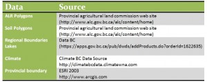
The ALR and soil data sets were found on the provincial agricultural commission website in the form of polygons, both of which were on the coordinate system NAD 1983 BC Environment Albers, and had to be clipped to the Okanagan boundary shape file. The soil capability data set included the 7 soil classes, areas with no data and the sub-classes, but for the purposes of this project, the sub-classes were not used.
The climate data was found on the climate BC data for current climate and future projections for 2025 and 2055, with the coordinate system GCS WGS 1984. The limitation involved with this climate data was the resolution of 800 x 800m. To improve this, more data needs to be collected to give more accurate climate data, reducing the cell size and accuracy.