The KATABATIC ANR project
On the steep slopes of Antarctica, we find some of the strongest winds on Earth. The very cold air from the center of the continent is very dense and literally falls down the slope of the ice sheet. We call it “katabatic wind”. It can become even stronger when the high and low pressure systems are aligned with the topography, adding the strength of a storm to the katabatic wind background.
This expedition will take us on the steepest slopes of Antarctica, at the D47 site in Adelie Land to study these winds, with three main goals:
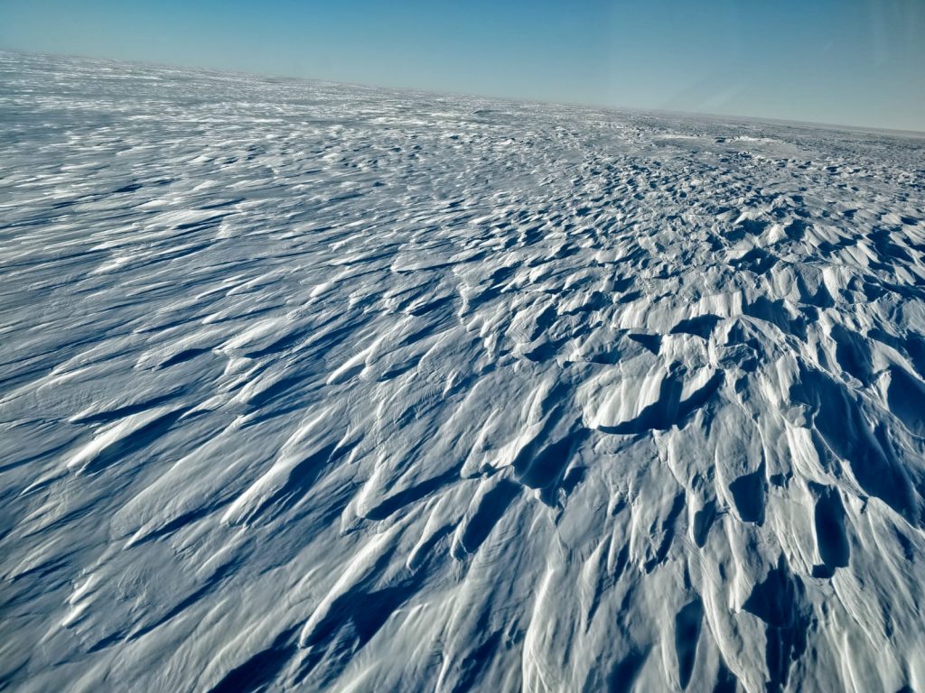
1) When the wind blows over the snow surface, it picks up the snow, transporting it for some distance and causing white out conditions. The wind also shapes the snow surface, creating dunes are strange features called sastrugis. These features are indicating of the wind strength and direction, and make the accumulation of snow on the ice sheet heterogeneous, patchy, and complicate the interpretation of snow accumulation in a 10cm diameter ice core. We will study how the wind shapes the snow surface.
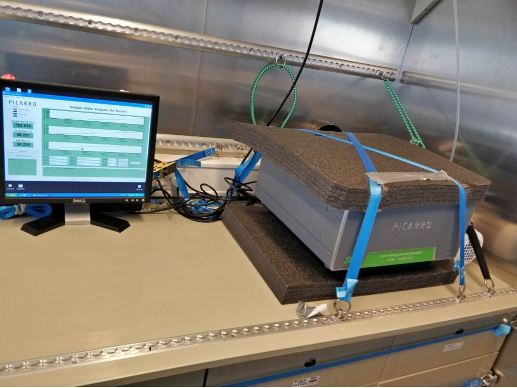
2) When air flows downhill, it warms up, and can hold more water vapor. As a consequence, the drifting snow evaporates, and this is a net loss of mass for the ice sheet. How important is his effect? Nobody knows, and we will bring a special tool to track this process: a water isotope laser spectrometer, supported by a suite of meteorological instruments to study the turbulence caused by the wind, and the associated moisture transport.
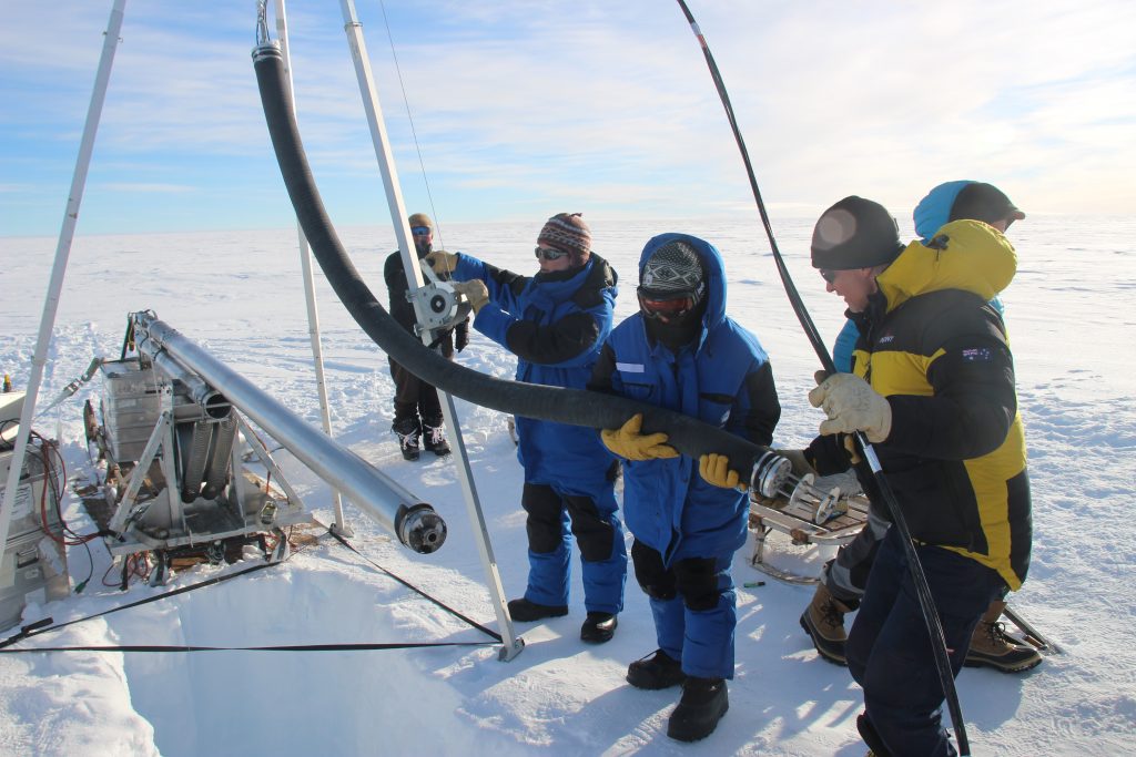
3) In order to get a longer view of the variability of the surface winds, we will drill an ice core, and develop a “proxy” (or tracer) for wind intensity in the ice. The snow at the surface is porous: there are holes in between snowflakes, and strong wind can mix the air for a few meters deep. When the wind is weak, gravitation tend to concentrate heavier elements deeper in the snow. By looking at how light and heavy gases change with time, we hope to be able to detect strong wind conditions. But this is just an idea. This year, we will make the first measurements of this kind in a windy place to see if it works. And if it does, we’ll have a 150 to 200m ice core, covering the past 100 to 200 years to give us a longer term perspective on how those strong katabatic winds vary in time.
The ICORDA ERC project
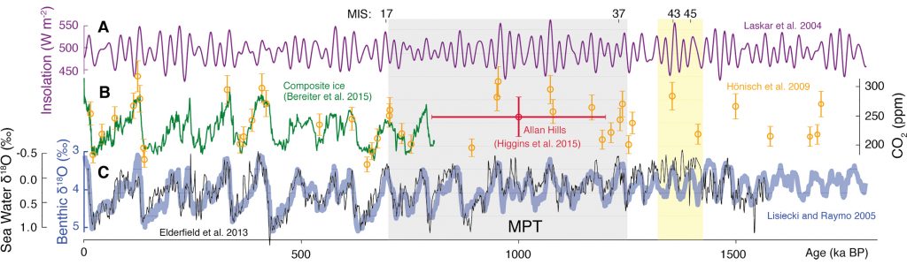
Paleoclimatologists are very curious about the fact that ice age cycles have changed their periodicity during the “mid-pleistocene transition”, 1.5 to 1 milion years ago. Before that, they were regularly spaced by 41 thousand years, but more recently, glacial maxima have been more intense (colder) and only returning every 100,000 years ago. (You can see this in the blue line in the figure below showing the ice age cycles: up is less ice, and down is more ice.) Why are we skipping cycles from time to time? Mystery, but this mystery probably has something to do with the carbon dioxide concentration in the atmosphere (Green in the figure below). And since ice cores trap a direct sample of the past atmosphere in air bubbles, they have a key role to play to explain how CO2 interacts with climate. We are studying the past, but it informs the present “CO2” experiment us humans are making by burning fossil fuels.
At Dome C, we have recovered the oldest ice core to date, called EDC (for EPICA Dome C), taking us 800,000 years before present. But we want to find older ice. At Little Dome C (or LDC), just 30km from Dome C, we have studied the bedrock precisely, and believe that older ice can be found. The ICORDA project contributes to this large international effort (the Oldest Ice core project) by focusing on finding out how old the ice is, particularly the gas phase.
In parallel to the deep drilling, which will take 4 years, our little group will study how gases get trapped in the ice at that particular site. We are particularly interested in how oxygen, a small molecule, gets expelled out of the ice during the closing of the air bubbles. We will sample the air in the open firn, and the air in the closed bubbles to see how this process happens, along with measurements of many properties of the ice: the concentration of dust and other impurities, the size of the crystals, the density etc.
We will also look at the snow surface, to see how different the surface looks when the wind is gentler. Is it going to be more pleasant? Not sure, because on the dome, instead of being -15°C outside like at D47, it probably will be closer to -40°C.
The ADELISE and Antarctic-snow projects
Antarctica is a continent covered in ice. But where does all the water originate from? We use water isotopes to study the atmospheric water cycle.
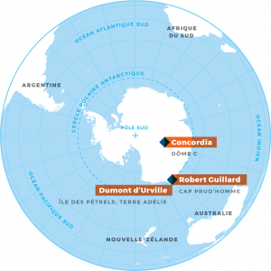
Water starts its journey by evaporating over the ocean in the mid latitudes. Then it is transported as storms towards the pole. When the air is cold enough, snow forms and falls onto the continent, making what will become an ice core. But the journey is not finished yet. The snow sometimes evaporates into water vapor before it reaches the ground. Often, surface snow is picked up by the wind, and transported some distance. After deposition, the temperature changes also cause many cycles of evaporation and sublimation that change the shape of snowflakes and snow grains. We study all of these processes with the help of water isotopes, and special instruments to measure the isotopic composition of the vapor, the surface snow and precipitation, in several different locations (Amsterdam Island, Dumont d’Urville, Dome C, and this year D47) to better understand the fate of water in all its forms on the Antarctic ice sheet.