The basics

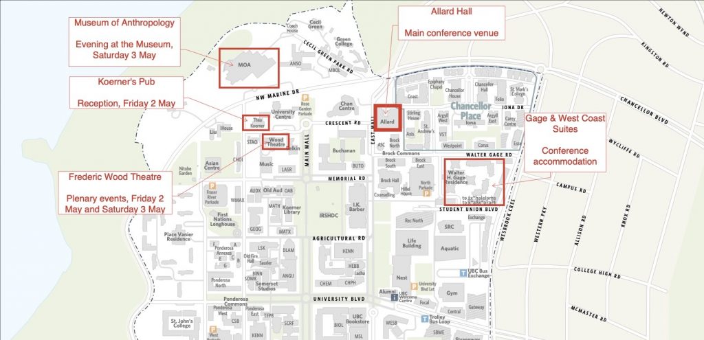
- For quick reference, the image, above, shows key conference locations on a map of the UBC Vancouver Point Grey campus. You can view, download, and/or print the full map here (PDF).
- All concurrent sessions will be held in Allard Hall (1822 East Mall). Plenary events will be held in the Frederic Wood Theatre (6354 Crescent Road). A more detailed program, including specific room locations, is available to conference registrants.
- General wayfinding on the UBC Vancouver campus: UBC Maps.
- A roundup of tips for visiting UBC: UBC Plan Your Trip.
- Information about specific classrooms: UBC Facilities, Learning Spaces.
- Locating all-gender and accessible washrooms on campus: UBCV Inclusive Washrooms map.
- Free, shared ride service for people with conditions that impact their mobility (Monday to Friday, 9am-4:30pm): UBC Accessibility Shuttle.
Public transit
Find information about public transit – including fares and route-planning – in Vancouver on the Translink website.
UBC Campus + Community Planning has maps of bus routes to the UBC campus and a map of bus bays at the bus exchange.
The exchange (or “bus loop”) is approximately 750m or a 10-minute walk to the conference location in Allard Hall.
Parking
The parkades closest to the conference location are:
- North Parkade (6115 Student Union Boulevard V6T 1Z1) – closest to Allard Hall
- Rose Garden Parkade (6278 NW Marine Drive, Vancouver, BC V6T 1Z1) – second closest to Allard Hall; closest to Friday and Saturday evening activities (Frederic Wood Theatre, Koerner’s Pub, and Museum of Anthropology)
There are also a small number of metered parking spaces in front of Buchanan E, which is directly across from Allard Hall (Buchanan Meter Lot, 1833 East Mall). These are the closest parking spaces to the main conference location.
Find information about parking locations and costs on the UBC Parking site.
Sunday 4 May road closures
The Vancouver marathon will take place on the morning of Sunday 4 May. This will primarily impact those travelling to campus on Sunday morning, as there will be road closures in the City of Vancouver and on the UBC Point Grey campus.
Scheduled road closures and recommended routes to campus
For travel to and from the UBC campus north of 16th Avenue (including the conference location), they recommend using University Boulevard or Chancellor Boulevard / 4th Avenue.
Planned road closures on campus are as follows:
- 8:00 am – 10:15 am SW Marine westbound/northbound CLOSED between West 49th Avenue and Camosun Street
- 8:30 am – 11:00 am – West 16th Ave CLOSED from Imperial to SW Marine Drive.
- 8:45 am – 11 :30 am – NW/SW Marine Drive CLOSED from West 16th Avenue to Chancellor Blvd
- 9:00 am – NOON – NW Marine Drive CLOSED from Chancellor Blvd to West 4th Ave
All roads around UBC will be reopened by noon.
Emergency vehicle access will be maintained at all times and access to UBC Hospital and St. John Hospice will be available at all times from University Boulevard to Wesbrook Mall.
For route maps and more information about closures and detours off-campus, please visit the marathon website.
