In this research paper, produced for my GEOG 410 course, I complicate our understanding of nature in the West to advocate for a new approach to environmentalism and collective action, one which recognizes nature in the everyday human experience.
Vancouver’s Local Food Movement and its Implications on Chinese Canadian Communities
This report looks into the ways that Chinese Canadian communities in Vancouver preserve, protect, and continue to contribute to their local food systems. In the context of historic racial discrimination in Vancouver’s food landscapes, we sought to illuminate the ways these legacies continue to affect Chinese Canadian communities, while outlining how these communities resist those legacies.
Analyzing the Extent of Hydraulic Fracturing in Northeastern BC in relation to Indigenous Lands and Freshwater Sources
In this project, myself, Anna Kaveney, Hriday Keshav, and Alex Newall decided to analyze an issue of which has risen to be very controversial, yet simultaneously does not commonly reach the masses through media streams. This issue is related to the proximity of hydraulic fracturing practices in northeastern British Columbia to Indigenous lands and freshwater sources. Recognizing the importance of doing this work, we set out to produce a set of maps that illustrate this particular case of environmental racism, as we believed a visual component detailing the problem could be helpful in allowing the greater public to fully grasp the issue at hand.
We split the tasks up among our teammates, though all worked together on each part as a collective. I was largely in charge of the map production and I worked on the report. Anna was largely in charge of the flowchart. Hriday made the visuals for the maps, and did a large portion of the report writing. Alex worked on the maps as well, found data sources, and also worked on the report. This setup worked well for us, and we were able to make the maps and report in an efficient and timely manner, though we definitely could have improved upon our communication to streamline the process.
The findings of this project were shocking. The proximity of wells and waste sites, as well as water access points were largely within 15 kilometres of Indigenous lands in northeast BC, and within 2 kilometres of freshwater sources. We studied the Montney Formation in particular, and found that there were massive amounts of freshwater access points threatened by the growth of hydraulic fracturing. Below I have attached a link to our project, where the results are more detailed.
This project taught me a huge amount about team work and how to function efficiently in a group work setting. Moving forward, I now feel much more comfortable working on GIS, as well as with a group, as this project required a lot of communication and participation from all members to make it come together.
I hope you enjoy!
Map Bias
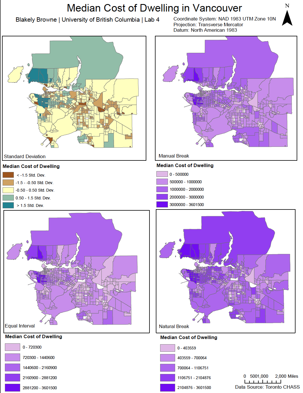
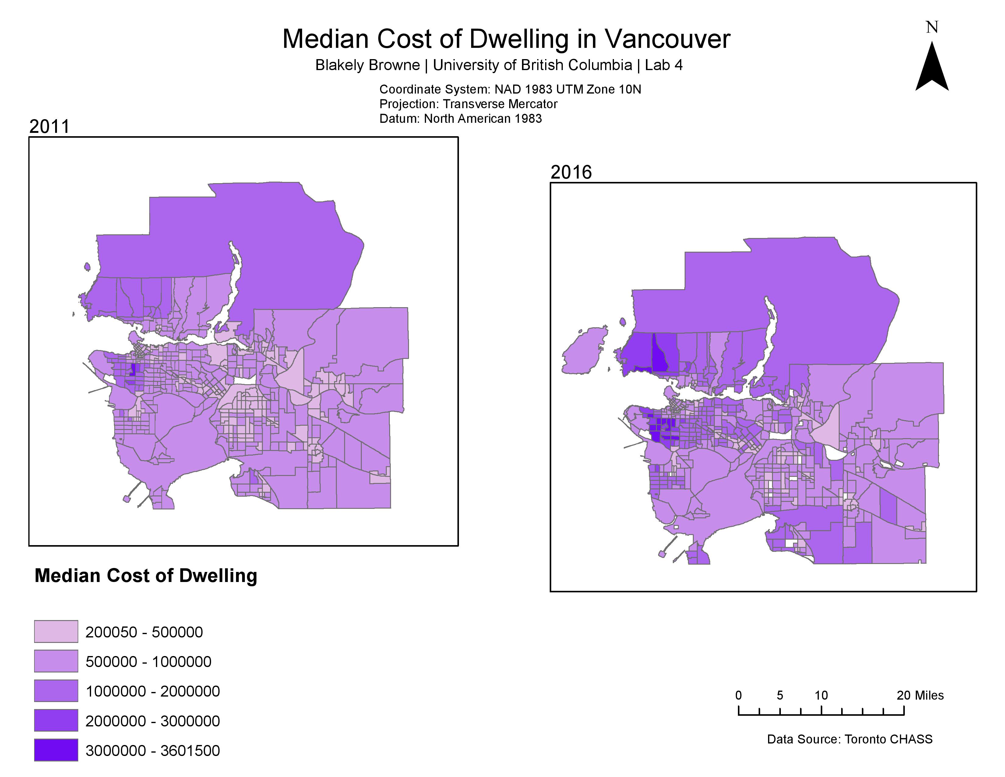
In this portion of our lab, we analyzed the different modes of data classification one can do in ArcGIS. Stepping away from this lab, I now see how the concept of map bias takes place, as we, as map makers, have the ability to choose a scale of which conveys a certain idea through varying visual representations. For example, the manual break, as seen above, makes more of Vancouver visually appear as low-cost, while other types show more of the true nature of Vancouver’s extremely expensive housing market.
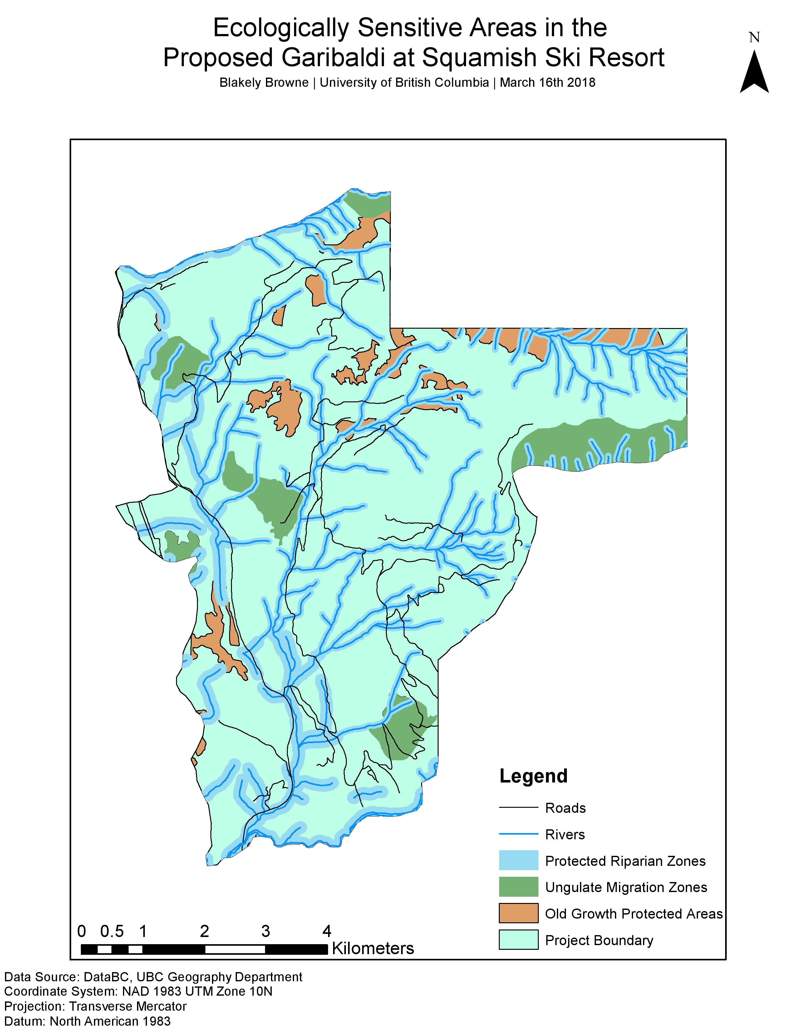
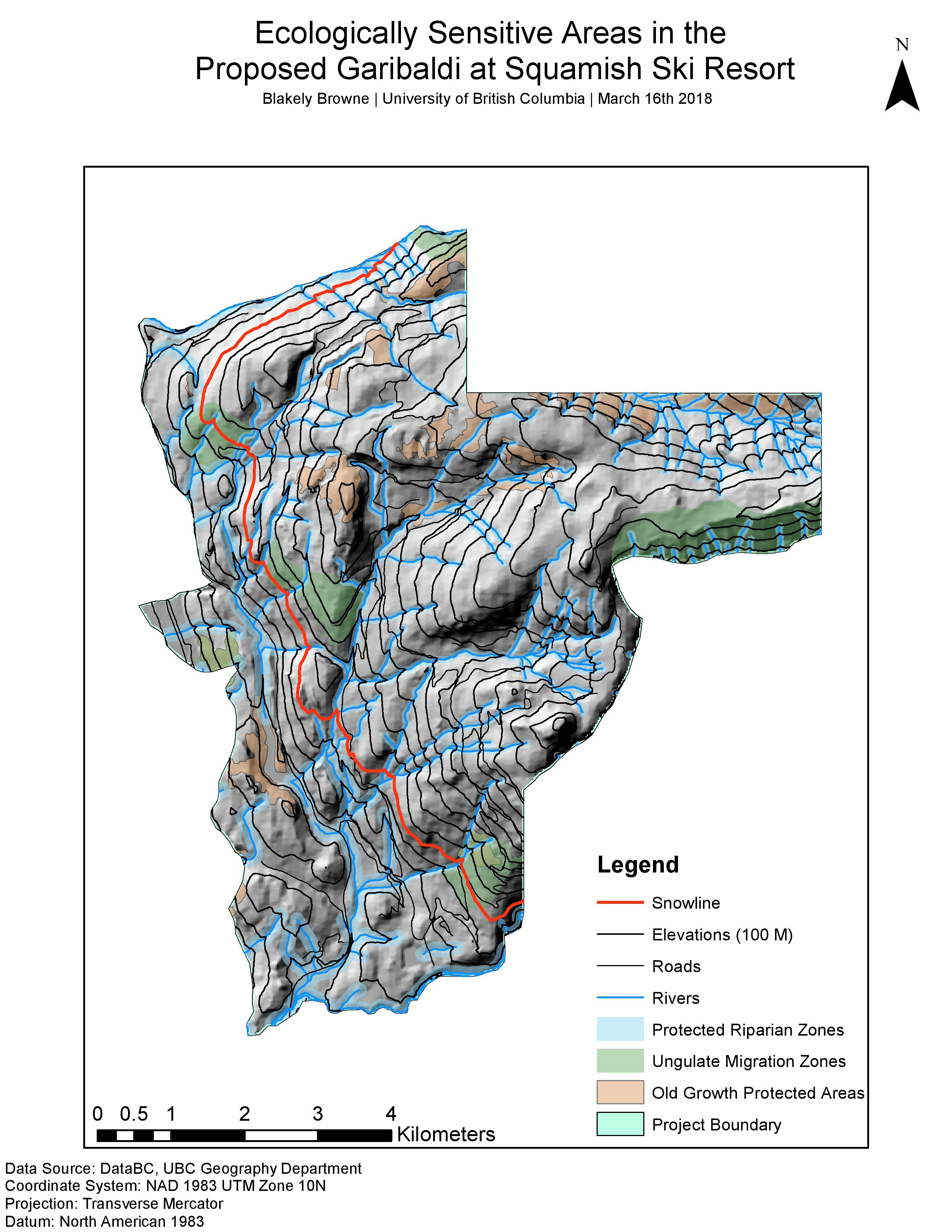
Ecological Sensitivity map for the Proposed Garibaldi at Squamish Ski Resort
In the following maps I display ecologically sensitive areas in the proposed Garibaldi at Squamish Ski Resort. These ecologically sensitive areas are ungulate winter ranges, old growth forest areas, and protected riparian areas.
Here is a sample policy memo I wrote to the Municipality of Squamish:
In this lab, I improved my abilities in ArcGIS through the utilization of tools such as the Clip, Union, Buffer, and through the use of visual tools such as applying a hill-shade, making the map look three-dimensional. This map helped me move forward into my final project for this GIS course, in which my group and I analyzed the extent of hydraulic fracturing in relation to Indigenous lands and freshwater sources in northeastern British Columbia.
Coloniality and Western Science
This term, in my Geography of Latin America class, we have been urged to leave behind traditional images of Latin America and what it means to us to investigate into how colonial power relations continue to play out and inform us about what goes on in this part of the world. In our first assignment, we were encouraged to think critically about the ways in which Western epistemologies and ways of being are not necessarily transferrable to all other places in the world, as we so may think. In the essay below, I discuss how Western science has contributed to the continuation of imperial power relations between largely North America/Western Europe and Latin America, to tease out these colonial relations that continue to be reproduced.
I hope you enjoy.
Vancouver’s changing housing market
This map I created displays the shift in median cost of dwelling from 2011 to 2016 within Metro Vancouver.
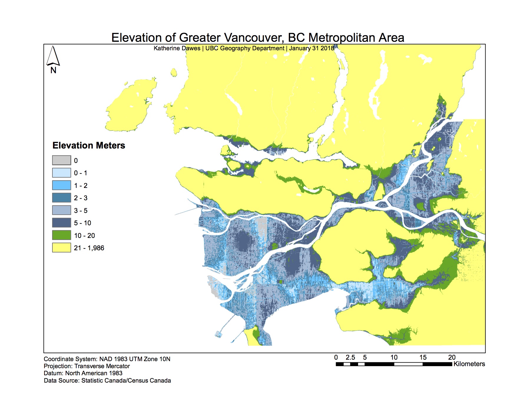
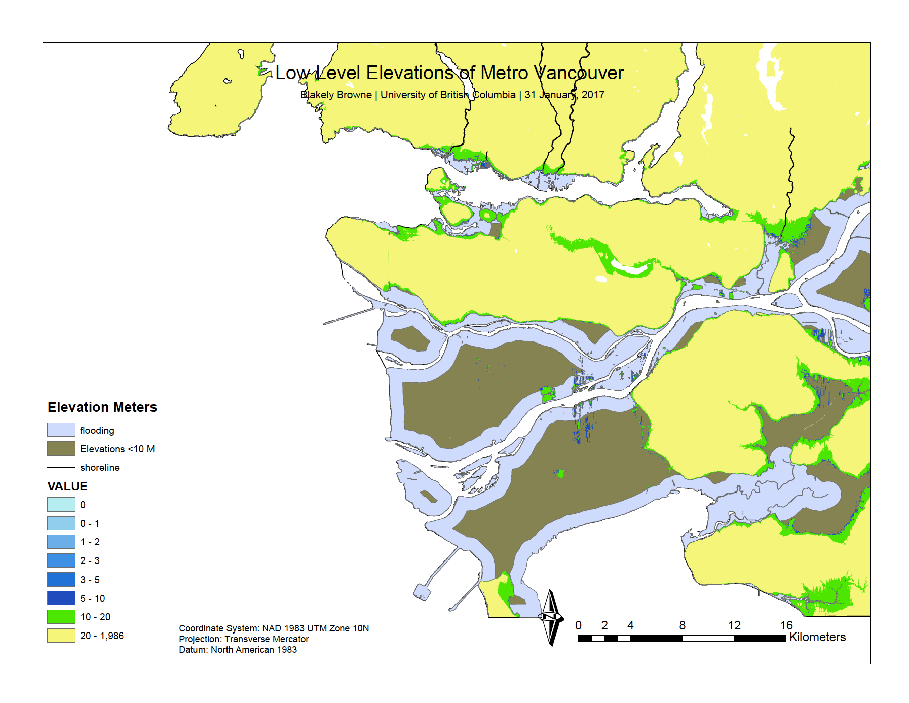
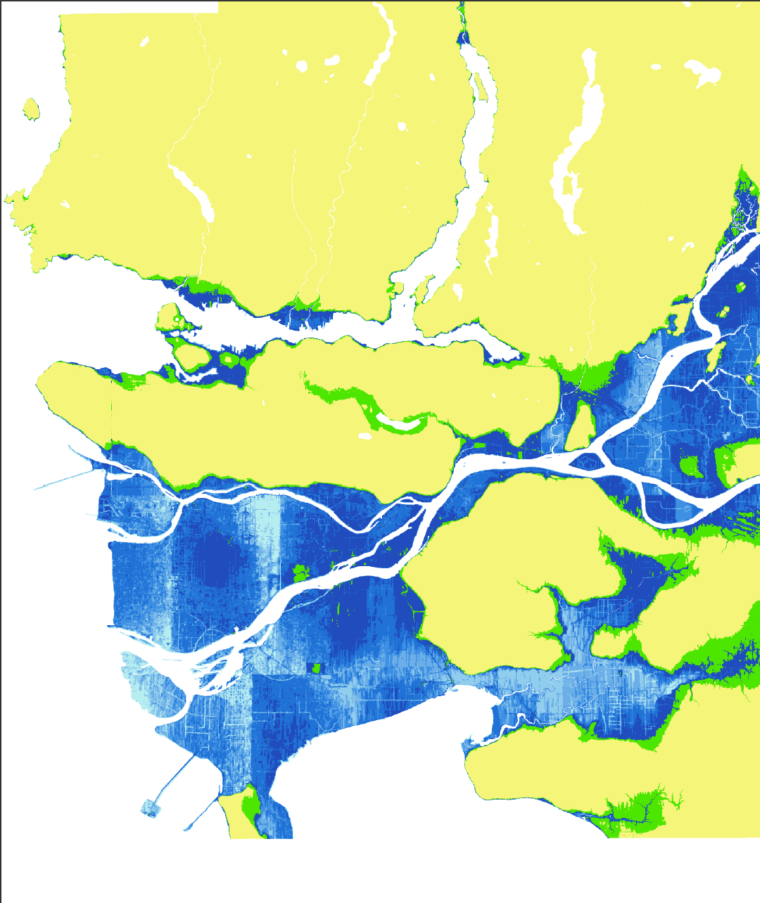
Flood-risk zones in Vancouver due to sea level rise
These maps display an analysis I did detailing areas of high flood-risk in Vancouver.
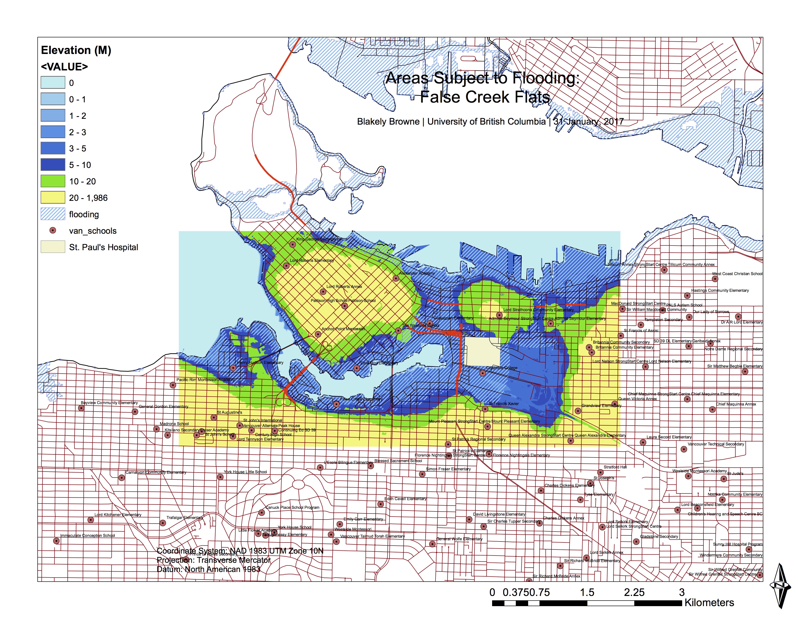
This map displays flood-sensitive areas in False Creek, as well as schools located within these flood areas.
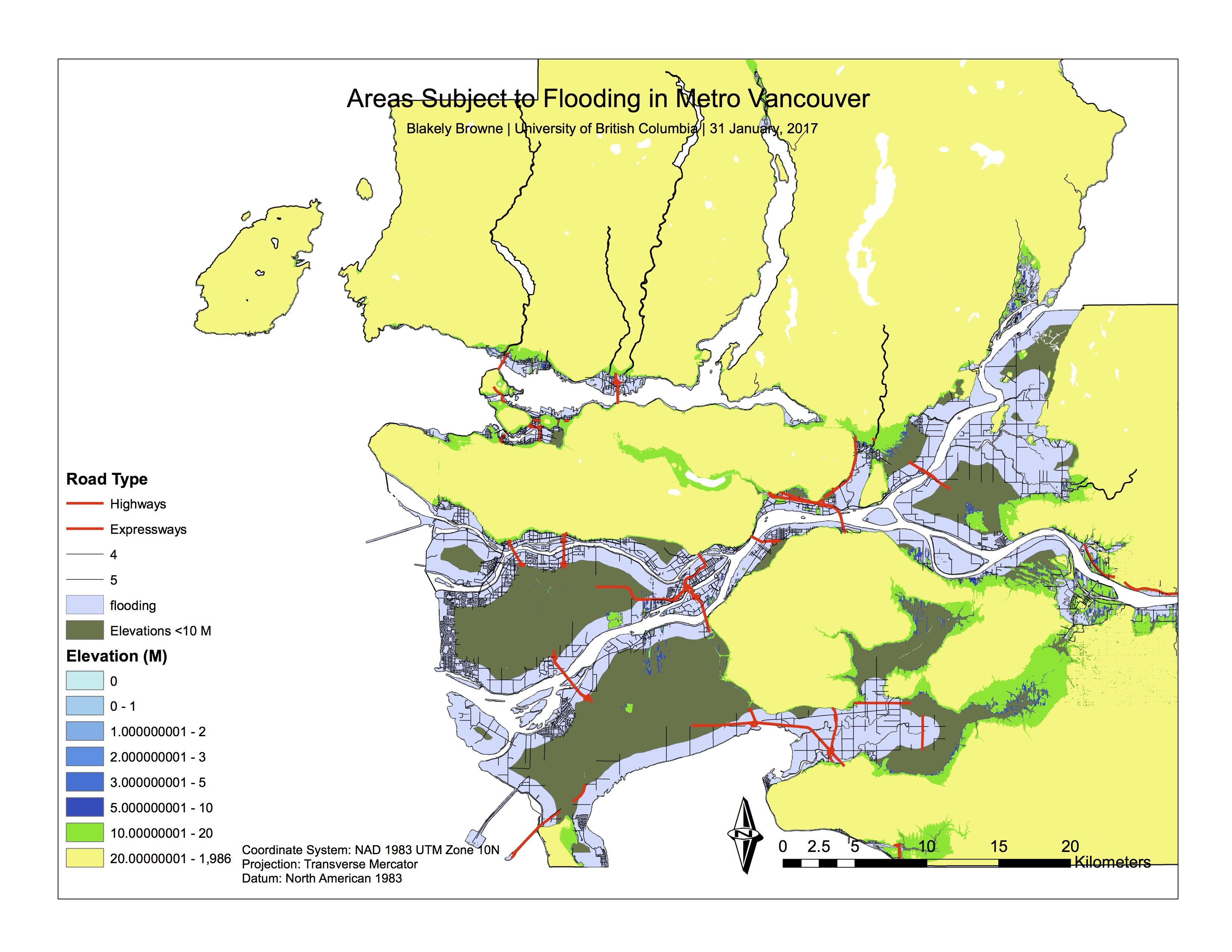
This map was an earlier rendition, prior to labelling and producing the final version.
Within this lab, I improved my geospatial analysis skills in ArcGIS by analyzing the ways in which a natural disaster could effect a cityscape, through the utilization of various tools such as buffers and selections (and the subsequent categorization of these selections).
Large Dam’s Infographic
Below, a peer of mine, Sam Tuck, and I have produced an infographic outlining the key driving forces, pressures, and impacts of dams on the state of the earth, and have finished it with a description of possible responses to the threats they pose. We hope you enjoy!

Breaking Barriers: A Look Into the Past, Present, and Future of Dams
During this first semester of my second year at UBC, I enrolled in a Geography 211 class taught by Dr. Loch Brown, in which we explored themes regarding the intersectionality between human societies and the environment, leading to discussion regarding the current state of the environment. We discussed topics such as consumption and technology, the global economy, culture and politics, and the history of the world, relating each back to its corresponding effects on the environmental condition.
As a term project, we were challenged to look at an environmental pressure of which has contributed in some way to the current state of the environment, and analyze it utilizing the Driving Forces-Pressures-State-Impacts-Responses (DPSIR) framework produced by the United Nations Environment Programme. The pressure I decided to hone in on was that of dams and their effects on environmental regimes.
Dams interested me because close to my home in Washington State are two large hydroelectric sources; the Grand Coulee Dam, and the Rocky Reach Dam. Growing up, I consistently heard of the positive change dams bring, such as providing clean energy for a majority of homes in Washington state; though I rarely heard of the negative qualities and issues these dams encompassed. In taking on this research project regarding dams and their effects on the environment, I hoped to see both sides to the story, and I did.
In my investigation of dams and their effects on the state of the environment, I discovered a vast quantity of research, of which opened my eyes to the complicated variety of issues they encompass. This research accumulated in the essay attached, which displays how and in what ways dams are utilized by human populations, and the negative environmental effects they have.
The following is an outline of the DPSIR model I analyzed:
Driving Forces
-Population Growth: In this section of my paper, I correlate the fact that the highest dam concentrations are present win the countries with the highest population. I point out that as the population of the Earth continues to grow, governments have looked to dams for the increased power and irrigation they provide, so that their populations have access to the electricity, food, and freshwater sources they need (Chen, Shi, Sivakumar, & Peart, 2016)
-A Desire to Progress: After discussing the role of population on the utilization of dams, I underline the fact that the majority of reasons for dam construction (electricity, agriculture, freshwater) are simply materializations of the underlying rhetorics and theories being harnessed in the world today, which can be most simply seen in the theory of modernity. I discuss the fact that high energy production can be seen to correlate with what can be conceived as a more modernized or advanced state, of which has the potential to be more successful and productive in the current, capitalist world economy (Isaacman, A., & Isaacman, B., 2013).
Pressures:
Dams: I omit this section in my essay, due to the fact that the pressure on the environment is simply the construction of dams.
Impacts:
Social Issues: When conversing with peers about dams, I have found the negative environmental issues they encompass to be more frequently discussed; but there are also a variety of social issues dams produce. These manifest in problems such as large relocations of people, and the seizing of the wealth of rivers from Indigenous communities. In this segment of the paper, I analyze how the construction of dams affects both settlements upstream, and downstream from the site.
Ecological Issues: The ecological issues dams produce are vast, though in my essay I chose to hone in specifically on the issues produced by reservoirs. I outlined problems the creation of reservoirs lead to, such as increased methane production, increased waterborne illnesses, and the salinization of soil.
State of the Earth:
Fragmentation and Homogenization: In this section of my paper, I focused on the effects dams have had on river systems on the global scale, detailing how the fragmentation of river systems has effects on biodiversity and river dynamics. To detail this more, I discuss how dams have had negative effects on migratory fish species, with specific reference to the Klamath River Basin of Southern Oregon and Northern California.
Responses and the Future of Dams:
Here, I discuss how the prevalence of dam construction has seen a drop in developed countries, but a continued persistence in developing countries. I argue that with the decline in dam production, there is an opportunity to improve dam technology so that they have less negative effects on environmental regimes, and can irrigate agricultural lands with higher efficiency. I also discuss how responses to dams, like attempts at restoring fish migration, are very varied in their success, with specific reference to the American Shad fish in the Northeastern United States.
Overall, I found this project to be largely beneficial on a personal level, as it led me to think about dams, their effects on the state of the earth, and potential ways to work towards their optimization so that they can function more efficiently, in turn minimizing their damages on the environment. In the future I can see myself pursuing activist positions surrounding dams and the social/environmental issues they embody.
Full paper:
Chen, J., Shi, H., Sivakumar, B., & Peart, M. R. (2016). Population, water, food, energy and dams. Renewable and Sustainable Energy Reviews, 56, 18-28. Retrieved November 18, 2016, from doi:http://dx.doi.org.ezproxy.library.ubc.ca/10.1016/j.rser.2015.11.043
Isaacman, A. F., & Isaacman, B. S. (2013). New African Histories : Dams, Displacement, and the Delusion of Development : Cahora Bassa and Its Legacies in Mozambique, 1965–2007 (1). Athens, OH, US: Ohio University Press. Retrieved November 10, 2016, from http://www.ebrary.com