– The Long History
Did you know that 26% of all Dutch territory is under sea level? Thus, we can easily say that the Dutch culture comes from water management. Flatlands induce the extensive use of biking as transport; the flatlands came from sea soil and are a mixture of clay that tulipe love. This soil is also great for growing grass and cow likes grass, and with cows, we produce cheese. I think that’s all for the Dutch stereotype… Let’s unravel the difference between Holland, Dutch and Netherlands before getting started. Holland was the name of a country from the 10th century to the 16th. Now, it is known as two provinces north and south on the western coast of the country, now known as the Netherlands. Holland became part of the Dutch Republic from the 16th century to the 18th century. Dutch is still a word use to refer to the people and the language in the Netherlands. After came the Kingdom of Netherlands. In this essay, we touch on the junction between the Dutch Republic and the Kingdom of Netherlands. It was a period of significant change and darkness for the country.
But how are they doing that? I mean managing water. They are fighting against the greatest natural force for hundreds of years. This incessant and timeless force that is the ocean uses wind and waves consistently to sink the lands. But Dutch have developed great technics to keep their land and gain some by creating polders and building dikes. The first step to all of that was the terps; they made little hills on top of which they build churches to get refugees in case of flooding. After, came all the knowledge of polders and dikes. Polders are the land below the surrounding water level. It is at constant risk of flooding and protected by dikes, a wall around the drying and drained land. They usually build a windmill next to it to pump the water out of that land. Using those technics, the shape of the Netherland has changed considerably between 1300 and 2000. They took over the sea lands and dug a lot of canals. Dutch once was an empire of trade and colonization, they were well known for their sea power, and managing water was always part of this power. In this essay, we will explore how the construction of the North Sea canal was an economical choice to bring back the notoriety of the Netherlands; and was a way to get back Amsterdam as a leading trade center of the Netherlands. From the Golden Age to the downfall of the Dutch Republic and the French ruling to the rise back of the Netherlands, every step led to the construction of the North Sea Canal to bring back power and trading.
One of the best economic periods in Dutch history was the Golden Age. Through their significant fleet, Dutch developed an important trade and colony network. “Manufacture was becoming diversified as a result of a whole new range of trade and industries opened up by the colonial commerce and the influx of skilled refugee” (Lambert 1985, 207) The Dutch were developing textile expertise, especially wool and linen, blending tea and coffee, refining sugar and cacao, cutting and polishing diamonds and making potteries. The Dutch Republic was flourishing, and “The overseas trade brought to the Netherlands more than profit: it made windows in the mind” (Boxer 1965, 25) They were testing ideas and innovation, and they were seeking knowledge and arts. During the Golden Age, Amsterdam was becoming a powerful city with one of the biggest port in Europe. “The rise to a dominant position within the country was based originally upon the city’s increasingly important role in the caring trade. Amsterdamers were at first merely carriers employed by foreign merchants, but they rapidly began to function as traders on their own account.” (Lambert 1985, 212) This economic expansion had the consequences of bringing more and more people into the city and contributing to a population boom in Holland. To support the increasing population, Amsterdam adopted a city plan and did a very intentional design of the canals in the city. They dug this series of four concentric half-circle canals in the city. It was, at time, a way to manage the water and, at time, a way to defend the city. As a result, Amsterdam became a very accessible boat city.
After two flourishing centuries, the country progressively fell into stagnation during the 17th century. A small country like the Dutch Republic couldn’t keep up with their growing empire, and they now had jealous enemies who taxed more and more the importation of Dutch produce. “the Dutch economy of the ancien régime was more dependent on income from trade with other continents than virtually any other economy in Europe, perhaps with the exception of Portugal. Trade was certainly less important to the British economy as a whole than to the Netherlands” (Oostindie and Roitman, 349) French and Britain shipping and trade soon replaced the Dutch one. The governance was also unstable between monarchies and republicans; the system was constantly switching. Consequently, the merchants fell into conservatism; they were enjoying their wealth instead of pursuing more of it. The upper class was not investing in new ideas and technical innovation anymore. For over a century, industries were getting smaller, and people were losing their work and getting poorer. In 1795, the revolutionary France took control on the invitation of the Dutch Patriots who wanted to restore the Republic. In 1806, under Napoleon’s (French) occupation, the Dutch Republic became the Kingdom of the United Netherlands as a gift for his brother. He also thought it would be easier to reign over in that way. When he finally left the Kingdom, he left the Netherlands without income and work. People were poor, and the country was under “economic stagnation and neglect took their toll, and despite bold Napoleonic plans for canals and high-ways, by 1813 the Netherlands transport system was in a state of decay. Unsatisfactory sea approaches to Amsterdan and Rotterdam, deficient harbour installations, a dilapidated inland waterway system and a road network both inadequate and in deplorable condition, hampered economic recovery.” (Lambert 1985, 273) Amsterdam’s principal interests were trades and traffic rather than manufactures and industries, and it was losing its income because “The city had lost much trade to rivals such as Landon and Hamburg in the eighteenth century, and the subsequent French occupation and Napoleon’s Continental System proved particularly disastrous.” (Lambert 1985, 284)
After the stagnation of the French period, a painfully slow economic revival took place under Willem I on the throne of the Kingdom of the United Netherlands. He officially gained back his throne in 1815; Willem I goal was to modernize the Netherland by improving ports, waterways and roads infrastructures. Steam power was first applied to polder drainage and then to industries. It really helped develop the country, for example, 30 windmills can drain a deep polder following careful steps; all those were replaced by one steam pumping station. It simplified a lot the drainage process. The objective of that process was flood protection and not land winning because the cost of drainage was higher than the gain from selling lands. The king also started engineering companies in Rotterdam and Amsterdam to bring industrial knowledge into the nation. Those companies helped to build back some of the prestige the Netherlands lost over the last century. “The Netherlands merchant fleet was rebuilt from nothing in 1813 to be the fourth greatest sailing fleet in the world by 1859.” (Lambert 1985, 268) Amsterdam still wasn’t doing well since there are no industries in the city and had a hard time trading. To help the city get back some of its glory, King Willem I requested the North-Holland Canal, it was build between 1819 and 1825. He first thought about the future North Sea Canal (Amsterdam to Ijmuiden), but they didn’t have the knowledge and the recourses to dig into the protection dune around Amsterdam. So they went with the safest idea, the canal running for 80 km between Amsterdam and den Helder. This canal shortly became obsolete with the steamships being bigger, the canal was soon too small for them, and many ships were instead taking the longer route or were trading at den Helder. “Between 1839 and 1859 the number of clearance of sea going craft at Amsterdam fell from 2357 to 1753, and the city began to fear den Helder as a serious trade rival.” (Lambert 1985, 274)

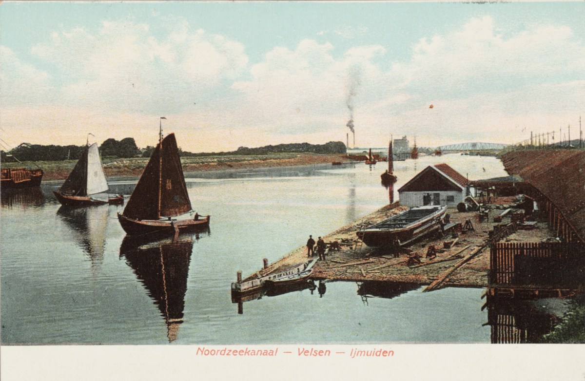
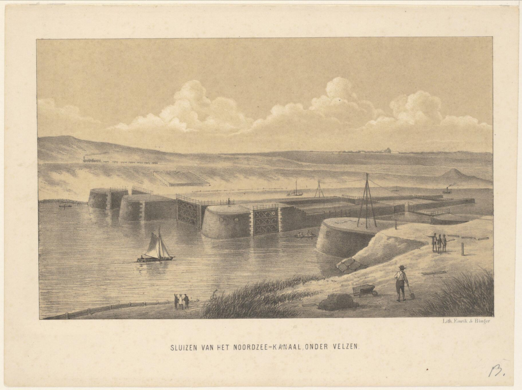
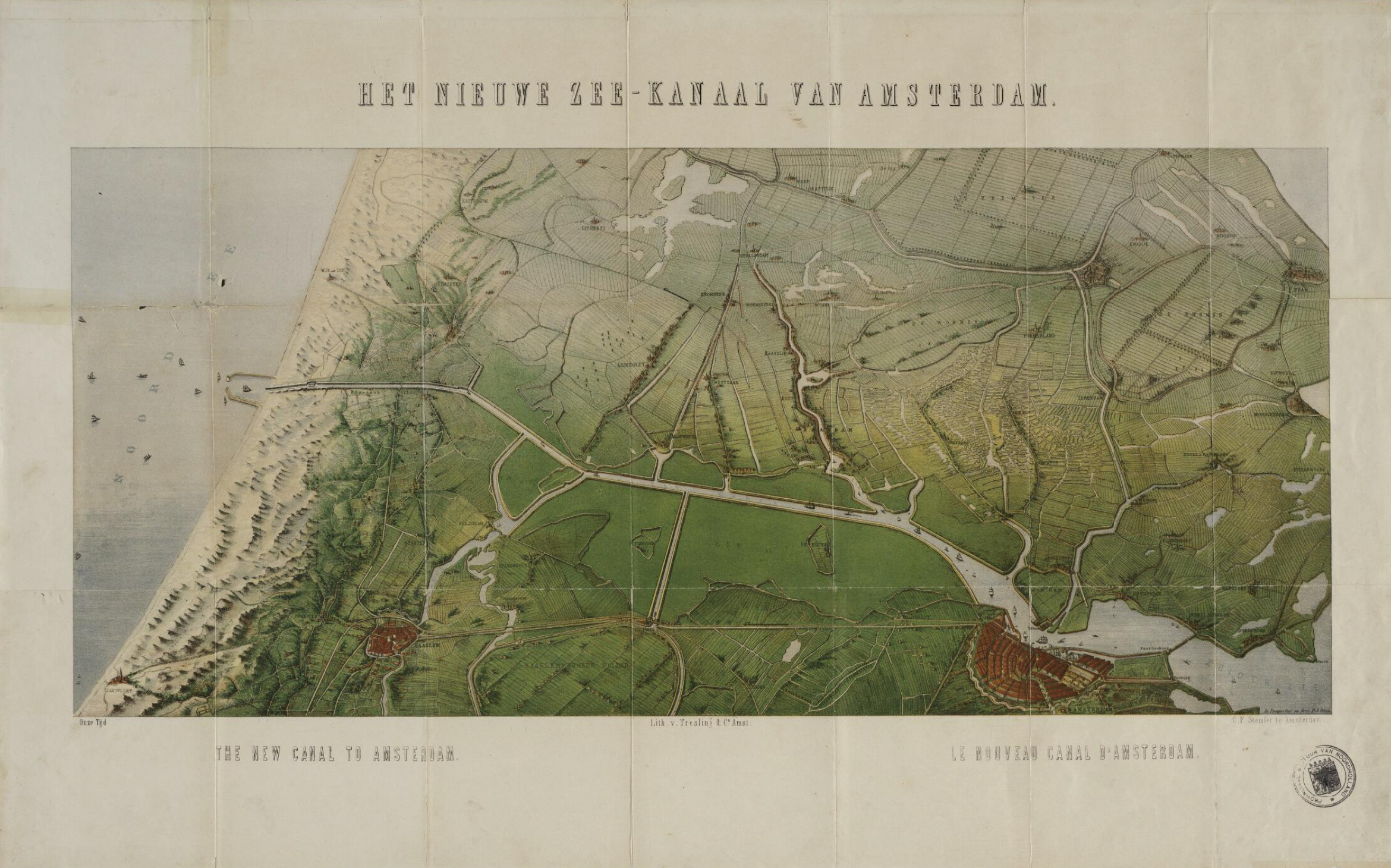
The construction site of the North Sea Canal opened on March 28th 1865. The plan was to dig a channel between Old IJ bay near Amsterdam and Ijmuiden by controlling water flow with dikes passing through the intimidating dune at Velsen. To accommodate drainage and shipping in cities other than Amsterdam, nine auxiliary canals needed to be dug. The canal was dug using manual labour, and workers lived in terrible conditions. They lived in huts built of branches and fights and alcohol abuse was proliferating. On the good side, with the completion of the locks on the North Sea and IJ bay, the North Sea Canal was no longer open to the sea and a specific water level could be maintained, helping with the overall land management of water. In November 1876, the North Sea Canal was officially opened by King Willem III. Between 1876 and 1879, the number of vessel in Amsterdam Port passed from 1100 to 1500.
The Netherlands was a powerful empire and is now a great country. After a few up and down, the creation of the waterways, more specifically, the North Sea Canal, helped them gain back their place on the world scene. This country will probably always be fighting with water and nowadays they developed a particular expertise a lot of countries could use against the rise of sea level.
Bibliography
1- Lambert, Audrey M. 1985. The Making Of The Dutch Landscape. London: Academic Press.
2- Boxer, C. R. 1966. The Dutch Seaborne Empire 1600-1800. London.
3- Oostindie, Gert, and Jessica V Roitman. n.d. Dutch Atlantic Connections, 1680-1800.
4- Woude, Ad van der, and Jan de Vries. 1997. The First Modern Economy. Cambridge Edinburgh Bldg. – Shaftesbury Road : Cambridge University Press.
5- Rutte, Reinout, Jaap Evert Abrahamse, and Otto Diesfeldt. 2016. Atlas Of The Dutch Urban Landscape. Bussum: THOTH Publ.
6- Bertram Black, Charles. 1908. Holland; Its Rail, Tram, and Waterways Adam and Charles Black. London
Figures
1- Beeldbank. 2021. Noord-Hollandsarchief – Provincial Atlas. https://noord-hollandsarchief.nl/beelden/beeldbank/?mode=gallery&view=horizontal&q=Noordzeekanaal&rows=1&page=1&fq%5B%5D=search_s_collectie:%22Provinciale%20Atlas%22.
2- Bertram Black, Charles. 1908. Holland; Its Rail, Tram, and Waterways Adam and Charles Black. London