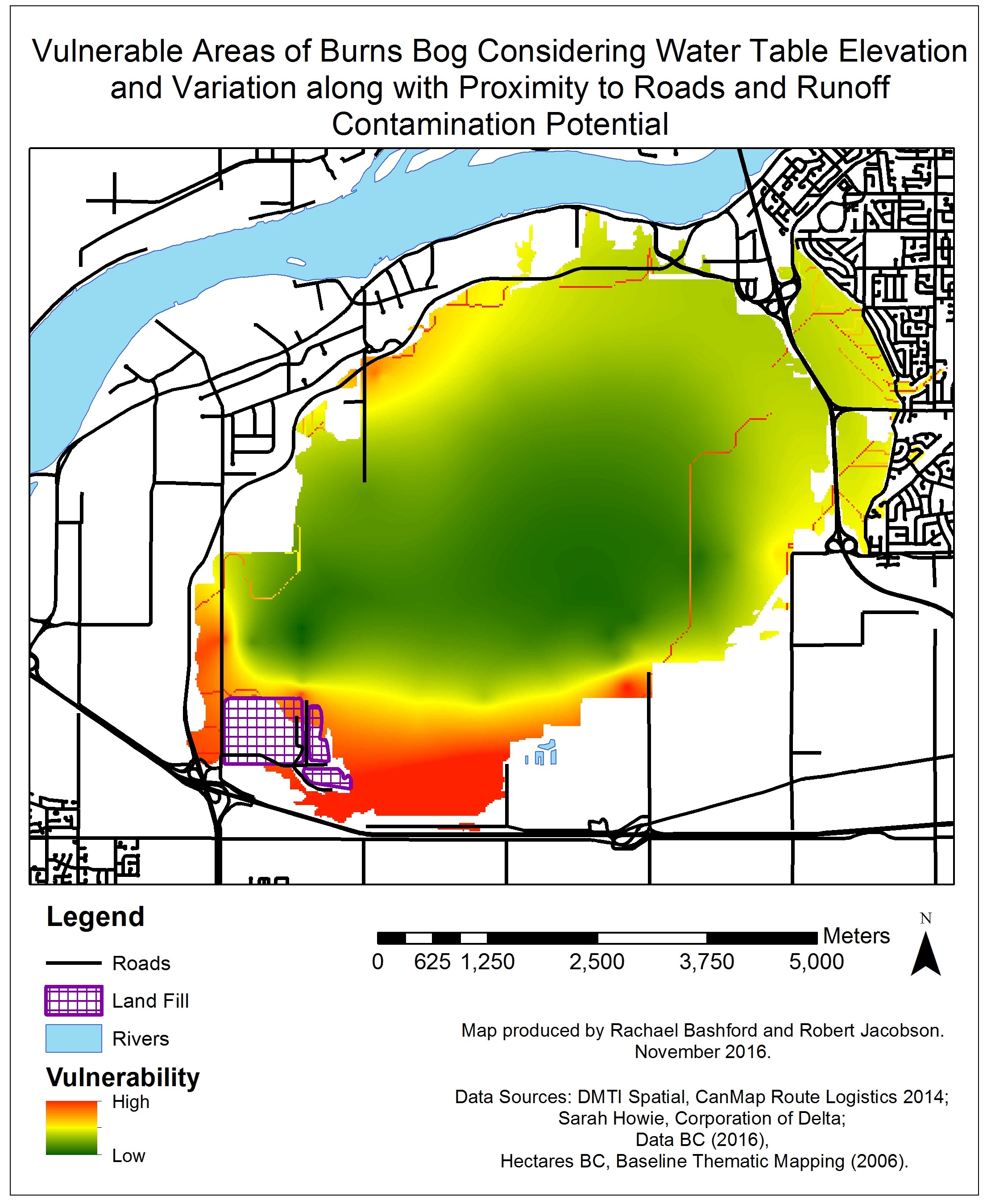
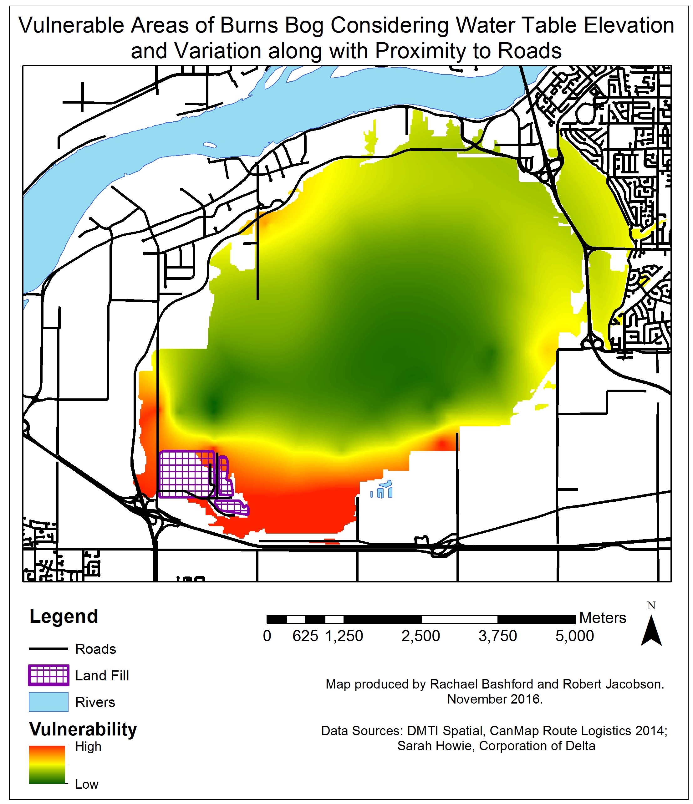
When conducting the multi-criteria analyses (MCE), we decided that implementing one with (Figure 7) and one without the runoff layer (Figure 9) was the best approach. The runoff layer includes many different assumptions and limitations to simplify the analysis, so a more in-depth approach to the creation of this layer could have resulted in a very different output. The sensitivity analysis in which all layers were weighted equally in the MCE did not appear to have a large impact on the areas of high vulnerability. However this did affect the size of the least vulnerable area, resulting in a more pronounced internal core of low vulnerability at the center of the bog, mostly as a result of the increased weight for the distance to roads layer.
The Delta Nature Reserve (DNR) in the northeast corner of the bog changed the most between the analysis that included runoff and the one that did not. As one can see in Figure 7, the DNR is the recipient of several streams of runoff that passed through or originated from agricultural and urban areas. This result is not surprising, as the Burns Bog Conservation Society has approached students in the ENVR program at UBC to help them understand why they are seeing a transition to forest vegetation in the area. Although a ditch exists in the area and serves the purpose of catching runoff from the upland residential area, it often floods in the winter, allowing the minerotrophic waters to enter the bog.
Regardless of the weighting scheme used, and whether runoff is considered, the southwest part of the bog always ranked as the most vulnerable area. As one can see from the maps, the Vancouver Landfill is located in that area. We were unsure how to quantify the potential impacts of the landfill on the bog, but did include it in the layer regarding runoff contamination. In the MCE that did not consider the runoff layer, the landfill had no direct impact on the results, yet that area was still the most vulnerable, which suggests that the landfill is impacting the hydrology of the area. Further research into the safety measures in place at the Vancouver Landfill and its environmental impacts could potentially make the area more at risk.
In light of all the results generated by our analyses, the southwestern portion of the bog shows the largest contiguous vulnerable area, so restoration efforts should be focused here. However many runoff streams, particularly in the Delta Nature Reserve produce tracts of high vulnerability. It, therefore, may also be important to identify where these runoff streams are entering the bog and prevent them at the source.
Conclusions
Though a simple analysis that makes many assumptions, our multi-criteria analyses revealed in all cases that the southwestern portion of the bog is most threatened. The Delta Nature Reserve is also an area that is quite threatened due to it being the destination of many runoff streams from land uses that result in a high input of nutrients. Future studies should focus on incorporating a much more in-depth hydrological analysis, especially as the bog is constantly threatened by further development.
Summary of Limitations and Suggestions for Future Studies
- The excel data set contained an uneven distribution and limited number of sample sites across the bog. More sample sites, especially in the northeast section of the bog, would make extrapolation of the point data to raster data more reliable.
- The exact weighting of layers is relatively arbitrary and could change the MCE output. However, the sensitivity analysis still identified the southwest portion of the bog to be most vulnerable, so the output appears to be robust.
- Only 4 criteria were considered in this analysis, but there are many other factors that can affect the vulnerability of Burns Bog.
- The runoff layer is a simple model. Soil permeability, groundwater movement, and precipitation amounts were not considered.
- Land use categories were put into a ranking system that may not accurately reflect the damage potential of the runoff originating in or passing through them.
- All of the roads were considered equal in the analysis regarding distance to roads.