Accomplishment Statement:
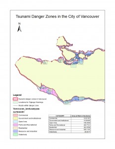
Using tabular and spatial data sets, a geographic analysis was performed on the City of Vancouver to assess the risk of danger of a tsunami on different areas. Calculations of the amount of area that would be affected was also carried out.
Map of Lab 3:
Percentage of the City of Vancouver’s total area under tsunami danger:
The percentage of area under tsunami danger is about 12%. The percentage was obtained by taking the sum of the areas of Vancouver_Danger layer and Vancouver_landuse layer from the attribute tables using the Statistics tool and dividing the sum of the area of the danger layer by the sum of the area of the landuse layer.
Healthcare and educational facilities within the Vancouver tsunami danger zone:
Education facilities affected:
- St Anthony of Padua
- Ecole Rose Des Vents
- False Creek Elementary
- Emily Carr Institute of Art and Design (ECIAD)
- Henry Hudson Elementary
Healthcare facilities affected:
- False Creek Residence
- Broadway Pentecostal Lodge
- Yaletown House Society
- Villa Cathay Care Home
I was able to determine this answer through using the Clip overlay tool which I inputted the layers Vancouver_health (health layer within the proximity of Vancouver) and Vancouver_education (education layer within the proximity of Vancouver). For the clip features, I put Vancouver_Danger layer in. This produced two layers which only displays the educational and health facilities within the tsunami danger zone in Vancouver. I was able to then access and identify the select locations through the attribute table of each corresponding layer.

