This project’s aim was to determine which areas in the Okanagan valley should be prioritized for riparian ecosystem restoration and management. This was done by finding the areas which had a higher concentration of endangered species (both aquatic and terrestrial) as well as those which were most vulnerable to degradation (due to proximity to agricultural areas, buildings and roads).
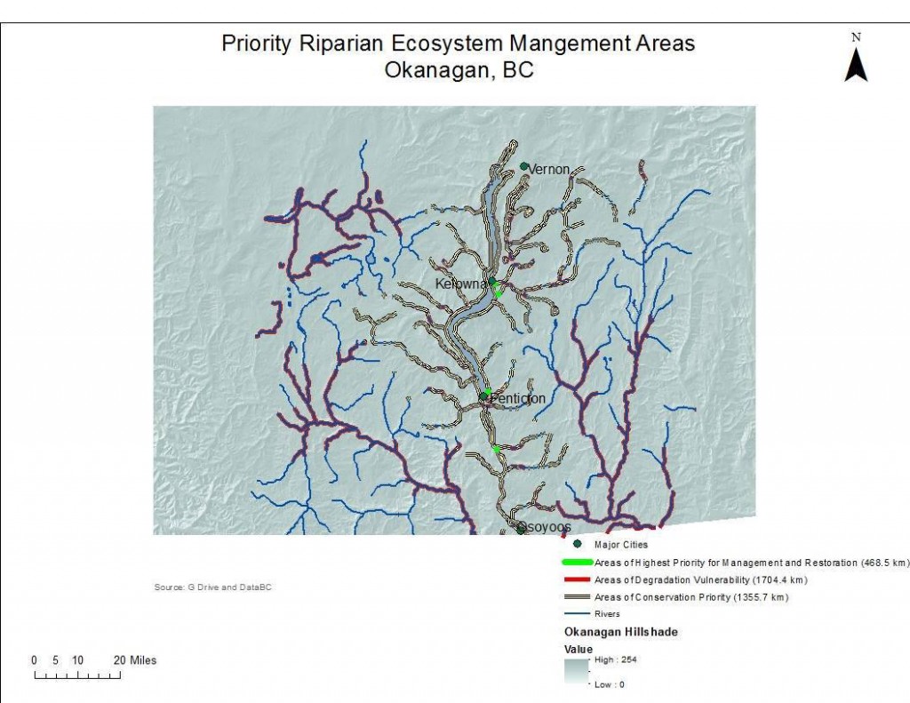
We found the Conservation Priority layer to cover a distance of 1355.7 kilometers (43% of the total river area in the Okanagan) and the degradation vulnerability areas to cover 1704.4km (54%).
The total area in the region that was within the range of all six studied factors (salmon species, fish species at risk, wildlife conservation areas, agricultural land use, buildings, and roads) was equivalent to 468.5km, or 15%, of total river length. This was concentrated in four major aras, two of them in the vicinity of the city of Kelowna, one in the vicinity of the city of Penticton and one just south of Skaha Lake between Penticton and Osoyoos.
The resulting map looked as follows:
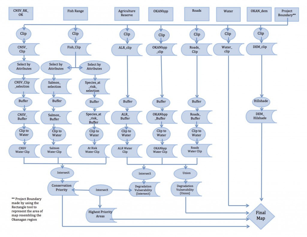
The analysis was done through a series of steps, including a wide variety of ‘selection’ and ‘overlay’ tools. The process outlined in the following diagram:
The whole report can be found in the following link: gisfinalreport.
Reflection: Teamwork and Data Gathering
This project was achieved with the help of three other group members: Andrea Le, Naomi Schettini and Ruimeng Pang. We all had similar interests in our focus of GIS analysis so teamwork ended up being extremely rewarding. We got together to plan our GIS analysis and then performed some parts individually and then reviewed them and put them together as a group. For writing the report, we all gave ideas through a ‘google document’ and each one of us took charge of writing one part. We all edited the final version through the use of the google document before submission.
The two most interesting aspects of working on this project that differentiated them from all other labs performed in class were: teamwork and the gathering of our own data.
Regarding teamwork, it was different to work in a context where information was being gathered and changed by different people at different times and locations. This was extremely important in building skills and knowledge about data handling. It was also rewarding to work with different viewpoints, as I sometimes found my own ideas challenged in positive ways that led me to a new, improved perspective.
Regarding data gathering, I was surprised by the wide range of sources in databases like DataBC. For any factor that we considered, there was always at least one dataset which included our project area and had the exact information we were looking for. However, it was often the case when the desired data was restricted and we had to look elsewhere for something that, often, was not as ideal as what we had originally found. This was important in making me realize the importance of open-source data, and how, before its big advent, it would have been extremely difficult to perform any independent GIS analysis.
Accomplishment Statement:
Applied GIS skills acquired in class, worked in a group environment and gathered individual data in order to plan and develop my first individual geographical analysis.