Paper Tigers and Roaring Maps
by kendra parkinson
In order to address this question you will need to refer to Sparke’s article, “A Map that Roared and an Original Atlas: Canada, Cartography, and the Narration of Nation.” You can easily find this article online. Read the section titled: “Contrapuntal Cartographies” (468 – 470). Write a blog that explains Sparke’s analysis of what Judge McEachern might have meant by this statement: “We’ll call this the map that roared.”
A narrative of a landscape is often portrayed by a map. Humans are visual creatures, and in order to interpret meaning within space, we have used maps to assign borders or allocate resources that are deemed useful to us.
In the instance with the Gixtsan and Wet’suwet’en and their map which shows their proximity to resources that have been ‘defined’ by colonizers, it is an example of using the colonizer’s language and reappropriating it for the colonized perspective.
Judge McEachern referred to the Gixtsan’s attempt as, “the map that roared,” meaning the map is ineffectual, or as Eades thinks of Sparke’s analysis of the situation, that it was a reference to paper tigers. In this instance, McEachern meant that their attempts are ineffectual, which is why the Gitxsan’s land claims were overturned and they had to proceed with the Supreme Court of Canada.
This contrapuntal form of cartography is powerful, reappropriating the knowledge so that it is useful for Gitxsan as opposed to the tool being used for colonising purposes.
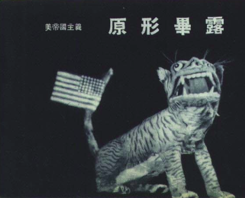
What I admire about the statement from McEachern is the irony in his word choice. Referring to the map that roared references a Chinese translation of ‘paper tiger’. McEachern professed his love of traditional conservative thought (a great fan of Hobbes for example) though his use of a communist statement that critiques an Imperialist, capitalist state is priceless. Reappropriation is prevalent on both sides of the legal argument, though the Gitxsan’s intentional use is noteworthy.
References:
Eades, Gwilym Lucas. Maps And Memes. Print.
Sparke, Matthew. “A Map That Roared And An Original Atlas: Canada, Cartography, And The Narration Of Nation”. Annals of the Association of American Geographers 88.3 (1998): 463-495. Web.
https://upload.wikimedia.org/wikipedia/commons/f/f7/1950-08-Paper_Tiger.png (Image)