El acueducto de Tribunas Córcega toma su agua de la quebrada Barbas, luego de que ésta se ha unido con la quebrada Sonora. Ellos han instalado dos equipos en cada corriente para comparar el comportamiento de ambas cuencas que tiene áreas muy similares (alrededor de 200 ha) ya que tienen grandes diferencias en el uso del suelo.
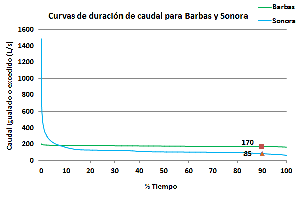
La cuenca de Sonora tiene el 48% de su área en bosque y 19% en bosque plantado (pino para producción de cartón), mientras que la cuenca del Barbas tiene el 71% en bosque natural y el 10% en bosque plantado. Ver mapa. Teniendo los datos de caudal vs tiempo que se mostraron en la gráfica de la página anterior, se pueden construir las curvas de duración de flujo, que ayudan a analizar el comportamiento del flujo en las quebradas.
En esta gráfica se puede ver la gran diferencia de comportamiento entre las dos cuencas:
Sonora no retiene el agua cuando llueve, aumentando mucho su caudal, pero a la vez disminuye mucho más su caudal cuando viene el verano; mientras que Barbas regula más el caudal de su corriente tanto en temporada seca como en la de lluvia. Estas gráficas entonces nos muestran como la vegetación, posiblemente, está impactando radicalmente la hidrología de estas cuencas.
English version: VI. Relevance
The Tribunas Corcega organization takes its water from the Barbas Stream downstream of the Sonora Stream confluence (see map below). This organization installed a water level recorder in each stream to compare the behaviour of both basins that have similar areas (about 200 ha) but differences in land use. TheSonorabasin has 48% of its area in natural (?) forest and 19% in planted forest (pine for lumber production), while the Barbas basin has 71% in natural forest and 10% in planted forest.
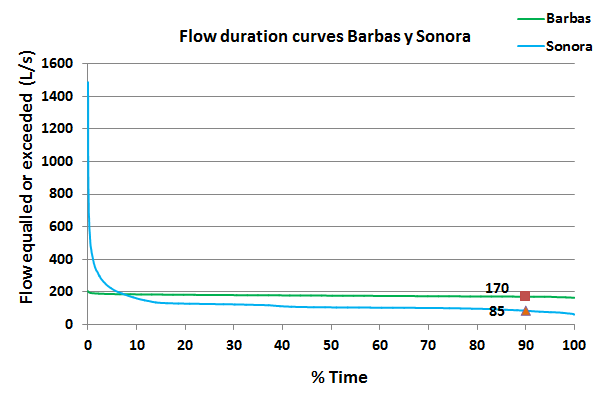
In this example, water flow data for both streams were presented in a flow duration curve (see graph below), which helps us to analyze the behaviour of the flow in the streams.
In this graph you can see the differences in behaviour between the two basins:
The Sonora stream (blue line) is a flashy system, in that it occasionally has very high flows (<5% of the time) but overall has lower flows than the Barbas stream (green line). These low flows are particularly apparent in the dry summer season, when the stream is fed primarily by base flow (groundwater discharge). The Barbas stream is more consistent and regular in its flow throughout the year. This information shows that the greater forest cover in the Barbas basin is likely regulating the flows of the Barbas steram, thus making the flows much easier to manage and allocate.


 Follow