
Part of the course focussed on reviewing 3 scholarly articles written about GIS. The three assignments were each focussed on
- Landscape Ecology and GIS
- Health Geography and GIS
- Crime Analysis and GIS
With my partner, Templar, we focussed on the following three articles.
A summary of another presentation, which I thought to be interesting, can be found at the very bottom of this section.
- Using patch isolation metrics to predict animal movement in binary landscapes Bender, D. J., Tischendorf, L., & Fahrig, L. (2003).
- Summary of the review can be accessed here:
- Hot spots in mortality from drug poisoning in the United States, 2007-2009
Lauren M. Rossen, Diba Khan, Margaret Warner (2013)- Summary of the review can be accessed here:
- Mapping sex offender activity spaces relative to crime using time-geographic methods
Downs, J.A. (2016)- A summary can be found below:
- Objectives:
- Mapping observed and predicted space
- Preventative tool for policy of future crimes + solving past crimes
- Focus on attempted rape
- Calculated surfaces and quantified areas most accessible to sex offenders
- The goal of the study: go beyond analyzing the issue using potential paths method and apply more complex models
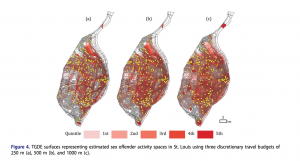
- The city of St. Louis in Missouri
- Methods
- Time-based geography methods based on potential path areas
- Two steps
- Time-geographic density estimation (TGDE)
- Intensity surface from combined activity spaces of offenders
- Data
- The analysis used data set of the home and work addresses of registered sex offenders in St. Louis
- Collected from the Missouri Sex Offender Registry (MSOR) in 2013
- Methodology
- Work + home addresses geocoded using ArcMap à result = 87 pair
- TGDE were then created using the 87 pairs
- Measures of intensity calculated from each node in the network
- 3 surfaces created (200, 500 and 1000 meters)
- Calculated shortest path distances between home and work using ArcMap’s Network Analyst Extension
- TDGE equation applied to shortest paths using Field calculator
- Calculated intensity values depicted using Voronoi Diagram
- Results compared to the Kolmorogov–Smirnov test
- Results
- Results of 250 TDGE surface à Highest intensity areas in central and eastern parts of the city along shortest paths between home and work
- 90% of rape incidents in activity space of previous offenders
- Significant results of the Kolmorogov–Smirnov test P-value results
- Showed that intensities at rape locations were higher than what would be expected at random
- Within the 500m scenario: 95.5% of rape cases occurred in the activity space of the sex offenders
- Within the 1000m scenario: 98% of cases
- Conclusion
- Successfully addressed the research question
- Detailed and appropriate use of methodology
- Relevant and clear maps
- Evaluation of the analyis – limitations such as time intervals
- Score = 8,5/10
Summary of Connor’s presentation
Other students presented their own articles, provided summaries and implications of their review. A presentation which I found particularly interesting was a review made about: “GIS-based analysis of obesity and the built environment in the US” by Yanqing Xu and Lei Wang – the presentation was made by Connor. The review was interesting, and unlike all other presentations which all attributed relatively high scores to their article, this review gave its paper a 6/10. The objective of the analysis by Xu and Lei was to examine the relationship between built environment and obesity between counties of states US states using geographically weighted regression. Although the analysis omitted a lot of variables such as age, gender, income, education level and such, the results showed that in most counties, poverty rate, street connectivity, and walk score played a role in obesity rates, and that the impact of the variables varied spatially across counties.