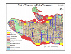
A map of Vancouver showing all the danger zones that are potentially at risk of being impacted by a tsunami.
Using data from a digital elevation model of Metro Vancouver to delineate areas that have an elevation under 15 meters and dividing the total area under danger (approximately 660 square kilometers) by the total area of the area of study, I found that over 50% of Vancouver is in danger of a devastating tsunami event. The areas represented in red are the danger zones that lie within 1 kilometer of the coast, and are therefore, at highest risk of being impacted by a tsunami.
Many of the most important healthcare and educational facilities are located within the boundary of the danger zones. Using a tool called Overlay-Intersect to create a new map layer that showed the all the healthcare and educational facilities that lies within 1 kilometer of the coast and at elevations under 15 meters. From this process, I found that Broadway Pentecostal Lodge, Coastwest Community Home, False Creek Residence, Villa Cathay Care Home, and Yaletown House Society are the healthcare facilities at risk. Meanwhile, École Rose Des Vents, Emily Carr Institute of Art and Design, False Creek Elementary, Henry Hudson Elementary, Heritage 3Rs School, the Institute of Indigenous Government, St. Anthony of Padua, St. Francis Xavier, St. John International, and Vancouver Montessori School are all the educational facilities that are at risk.