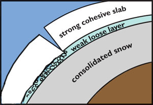
An understanding of what an avalanche is and how it is initiated is required before any forecasting can be considered. The major concern for backcountry users in mid wintern is the dry slab avalanche. A common analogy is a magazine sliding on an inclined table. For this to occur a cohesive slab of snow must exist on top of a weak release layer underlain by another stiff basal surface. This general structure is illustrated below.

Snow layer combination likely to produce an avalanche. Image from Forest Service National Avalanche Center.
Just because these layers exist in the defined order does not mean an avalanche will occur. Stresses in the downhill direction must exceed the strength of the cohesive layer to initiate a slide. The first consideration is the slope on which the layered structure exists. It is commonly accepted that slopes above 30 degrees are avalanche prone with 38 degrees as the sweet spot for releases to occur. Slopes much higher than this are less likely to slide as snow typically does not accumulate. The release of a slab avalanche often occurs at convexities in the slope, as illustrated above, or on a planar surface with the introduction of initiating force such as new snow loading, wind blown snow or a backcountry traveling enters the slope. This gives rise to the three phase construction of an avalanche: weather, terrain and snowpack.
The current approach to avalanche forecasting is a broad regional consideration. Historic records of precipitation history are considered against recent weather and spot observations with the assumption that in any given area there exists terrain capable of producing avalanches. The Canadian Avalanche Center does a fantastic job at highlighting avalanche concerns for the broad regions susceptable under there scope. Included within each of these regions are areas too steep to accumulate snow, too shallowly dipping to be of concern, and the slopes prone to avalanching that are often the ideal angle for backcountry recreation.
This projects is an attempt to focus on the existing terrain using a geographic information system (in this case ArcGIS) as the foundation for avalanche prediction. Added to it is a basic understanding of the current weather conditions to quantify avalanche hazard as low, moderate, considerable, high or extreme (the accepted 5 tiered system). In this manor the spatial and temporal variation of the hazard is presented. It is by no means complete or even accurate, but is an attempt to show that GIS can be coupled with weather data to give a focused localized avalanche prediction.
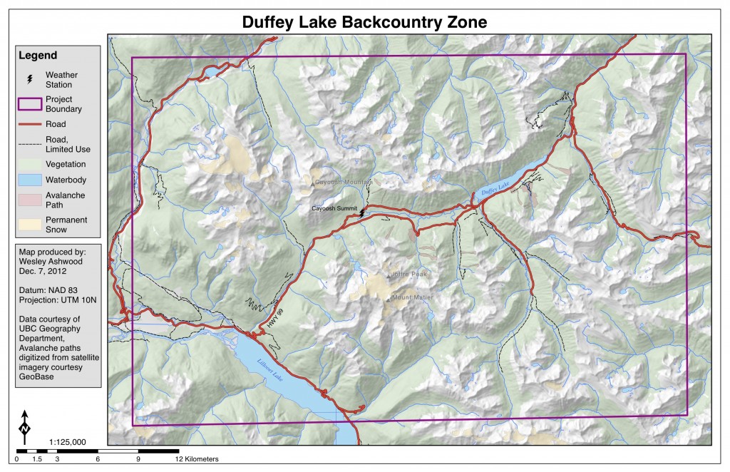
The focus of this study is the Duffey Lake backcountry zone centered around Cayoosh Pass NE of Pemberton, BC. Backcountry skiing and snowboarding terrain is easily accessed from the 1250 m pass summit. Also located here is one of many Crown sponsored weather stations. This data, updated hourly, can be used as inputs to a Python module executed in ArcGIS to aggregate data and perform a multi-criteria evaluation. The general zone of interest is depicted below. At this point in time only areas above tree line and in specific avalanche paths are considered.

