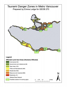
Although the city of Vancouver is protected from most tsunami danger by Vancouver island, there is still a risk of damage and danger in the city, particularly in low lying areas below 15 m above sea level and within one kilometre of the shore line. This map highlights where those danger areas are, what type of land use would be affected, and what type of road would be affected. I have also highlighted areas where signage could be placed to warn the public of this danger.
From this map and subsequent analysis, I concluded that 15 percent of the total area of Vancouver is in the danger zone. To find this, I used the statistics tool within ArcMap to find the total area of Vancouver and the total area of the danger zone (below 15 m and within one kilometre of the shoreline) and divided the two.
I also discovered that there are four health care facilities ( False Creek Residence, Villa Carthay Care Home, Yaletown House Society, Broadway Pentecostal Lodge) and eight schools (Henry Hudson Elementary, Emily Carr Institute, False Creek Elementary, Vancouver Montessori, St. Anthony of Padua, Heritage 3Rs, the Institute of Indigenous Government, Ecole Rose Des Vents) within the danger zone. This was discovered when I used the ‘Select by Attribute’ feature of ArcMap to look at the EDUCATION and HEALTHCARE features that were within the danger zone.
