A sharp wind blew from the coastal mountains, whose peaks, textured with early snow, caught the salmon light of an autumn sun now hidden from view. The brisk air swept south across the broad brown expanse of the Fraser and whistled through the log palisade of Fort Langley National Historic Site. The four figures crouching in the damp earth in the fort’s south-east corner were not sheltered from the chill. They wore reflective vests and sifted through the soil with spades and trowels, spaced out at even intervals within a rectangular excavation area. No one spoke as they made use of the last of the light.
Audible only to the one wielding it, a spade struck wood. Slowly and furtively, the digger cleared away the surrounding soil. When the others had moved off into the darkness, their work for the day complete, he lifted out of the earth a small oaken chest. He brushed it off with a feeling of awe. Then he brought it into the Big House, where they were collecting all their findings. Flicking on the lights, he carried the chest to table in the corner and set it down carefully. He checked it for fastenings and opened it.
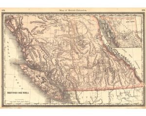
Inside was a large piece of vellum, folded many times over. After unfolding it, he adjusted his silver-rimmed glasses and brushed back his dark hair. Set on the vellum in dark ink were the unmistakable lines of British Columbia’s Pacific coast. On the left of the map islands were sketched in fine detail. On the right triangular shapes seemed to represent the Rocky Mountains.
His eyes widened. Criss-crossing the map—especially its southern portion—was a network of faint lines, thin as hairs. But that wasn’t all. In certain places, underneath the gridwork, stranger forms asserted themselves, half erased: the slope of a valley, the hint of dwelling-place, and words—unfamiliar symbols whose sounds he did not know. They reminded him of names he had given to well-known trees in Tolkien’s Elvish—long, graceful, unique names. He took a picture of the map with his phone, replaced it in the chest (which he tucked into the corner), and moved to go.
A tall, bald man intercepted him in the hall.
“Hi, Dr. Perks.”
“Any big finds today, Alex?”
“No, nothing much today.”
“Well, see you on Monday.”
“Good night.”
The dim parking lot was full of mouldering brown needles and brittle leaves. Alex got into his car and started on his way home.
Fort Langley was hopping on a Friday night, the patios full, the main street roaring with passing cars and trucks. Anonymous faces and blank windshields. Young families who’d moved into the suburban new builds by the river.
Soon Alex was driving through the fields. After ten minutes he turned onto a leafy side street and then pulled into a driveway in the gap of a tall hedge. A familiar skyline—silhouettes of poplar and maple. But unfamiliar shapes possessed his mind: half-hidden names and enigmatic lines of ink on vellum.
———-
The next night around midnight Alex was driving back towards Fort Langley. He had strapped a light wooden ladder to the top of his car. Both hands on the wheel, he breathed slowly and deliberately.
That day he had scrutinized the photo on his phone. He’d puzzled over the lines, and cross-referencing the image with Google Maps had left no doubt. It was bizarre—impossible, really. The map looked centuries old, but it showed today’s motorways: all the main roads and highways.
No one else had seen it. Alex felt an ardent curiosity bordering on possessiveness. He didn’t think it right that this thing should fall into institutional hands.
Alex drew his car up close to the east wall of the fort. He carried the ladder hurriedly to the palisade and steadied it. Forts. What would it be like to have one of your own up in the mountains, to live quietly among the endless forests? For now, the illicit pleasure of breaking into this relic would have to do. Alex balanced on the top of the wall and muscled the ladder silently to the other side, proud of his agility. Within five minutes, he had unlocked the Big House with his key, snatched the chest and its contents, returned, scaled the wall again. Then he was on the road home, in the car’s privacy.
———-
He had told his family cheerily that he needed time and space to work this Sunday. He had passed a day of questions and wonder. Now the map was laid out on his desk, and he stood over it with a scalpel.
The hidden forms, he knew, had not been erased but covered. If he could only uncover them . . .
He approached the surface of the map tentatively with the edge of the blade. He began scraping with almost imperceptible pressure. There was a sound to getting it right, there in the quiet of the room before the picture window—a faint craking like the singing of a cricket. The map began to show itself.
The dense gridwork gave way to long undulating lines. Railways? Alex kept at it doggedly. He couldn’t understand everything he was seeing: streams, dikes, ditches dug to drain the floodplains of the Fraser, footpaths, hills, rivers. Strangely, the map didn’t seem flatten as he scraped off minute layers; rather, in seemed to gain in depth. Was this a trick of the light?
Suddenly, the area under his knife burst into colour: earthy pigments, the colours of fern, moss, clay, and dried grass. Alex almost gasped. He had forgotten the names and words for the moment, although these were more numerous than ever; he could not make sense of them now. He seemed to see to the hidden sources of rivers. He smiled. Through the window, the sun shone through leaves, and the wind carried voices of the family as they readied the canoe for a Sunday expedition.
Works Cited
“Fort Langley National Historic Site.” Parks Canada, https://www.pc.gc.ca/en/lhn-nhs/bc/langley. Accessed 10 February 2021.
“Urban Palimpsest.” The University of Kansas – The Commons, https://thecommons.ku.edu/urban-palimpsest. Accessed 10 February 2021.
Image Credit
Hardesty, H.H. “Map of British Columbia.” The Historical and Geographical Encyclopedia, New York, H.H. Hardesty and Company, 1883. Alabama Maps, http://alabamamaps.ua.edu/historicalmaps/canada/bc.html. Accessed 10 February 2021.