Location: Granville Island
elevn: 4.405m. Lat. 49.272832 Long. -123.134466
Direct Google URL: This link takes you to a prepared viewpoint.
Hazard type: eq
Short Description: Reclaimed tidal flats and costs of seismic upgrades
Long Description: In the 19th century, the area which is now Granville Island was a tital flat composed of soft, saturated sand. Iin 1915, the Vancouver Harbour Commission reclaimed this land using artificial fill and turned it into an industrial area. Now a busy tourist and commercial area, Granville Island still sits on fill, putting it at risk for liquifying during future earthquakes. The Granvile Bridge, and most other bridges (and tunnels) in the lower mainland have undergone seismic upgrades, costing Metro Vancouver over $100 million.

Granville Island looking South West, from Granville Street Bridge, Vancouver, BC.
media1: False creek threatened by liquefaction in major earthquake; Global News, Dec. 3, 2013.
media2: Best & Worst Places to be in B.C. in an Earthquake; Eyes of Vancouver Breakfast Television interviews SFU geologist John Clague, January 2015.
In Depth: Earthquake discussion with figures from Geoscape Vancouver. Explore this site – it’s a little old but excellent.
3D interactive “Holobuilder” environment, from UBC Geography at 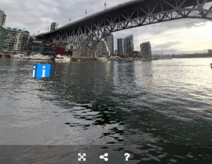
https://blogs.ubc.ca/fieldtrips/stops/stop-1-granville-island/
Some content on this page has been copied, adapted or referenced from Dep’t Geog. UBC’s virtual field trip blog, https://blogs.ubc.ca/fieldtrips/.
![]()