Location: Lions Bay
elevn: 130.879m. Lat. 49.458118 Long. -123.232567
Direct Google URL: This link takes you to a prepared viewpoint.
Hazard type: ls
Short Description: Harvey creek and mitigation of debris flows
Long Description: Roughly 50 people have been killed in the past century by debris flows and other landslides along the Sea to Sky Highway. Therefore, multiple mitigation structures have been built since the 1980s to reduce the hazards to residents and motorists. This dam on Harvey Creek is one example. It is designed to contain a “200-year event” – i.e. the largest event anticipated (based on engineering and geotechnical modelling) to occur in a 200 year time frame. Cemented boulders in the creek will reduce the energy of the flow and the dam itself will help contain material being carried down from the mountains above. Look for this and other structures on creeks along the Sea to Sky Highway and in adjacent communities.
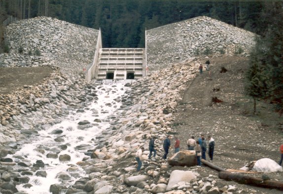
The bed of Harvey Creek below the retention structure. Boulders have been set into the stream bed with concrete. From https://web.viu.ca/earle/howe-sound/
media1: Set of photos by Steven Earle, Earth sciences, Vancouver Island University, 2000-2003.
media2: News, January 2016; rock slide near Horseshoe Bay
In Depth: Hazards in the sea-to-sky region; a discussion with figures from Geoscape Vancouver. Explore this site – it’s a little old but excellent. See especially figures in the section titled “Treacherous Slopes and Debris Flows”
Some content on this page has been copied, adapted or referenced from Dep’t Geog. UBC’s virtual field trip blog, https://blogs.ubc.ca/fieldtrips/.
![]()