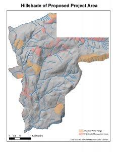
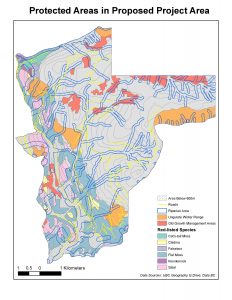
I have evaluated the proposed mountain resort on Brohm Ridge north of Squamish using the attached maps and have several recommendations to be considered for the project going forward.
The maps attached were created using data from the DataBC data catalogue and the UBC Geography Data collection. For my analysis I created a model depicting the various protected areas and natural resources on the site area including red-listed ecosystems, habitats, riparian and fisheries areas and old growth forest sites. In total 52.67% of the proposed project area will fall within these protected areas while individually they occupy as follows:
- Old Growth Forests: 6.78%
- Mule Deer and Mountain Goat habitat: 7.89%
- Red-listed species: 24.83%
- Fish habitat and Riparian areas: 26.29%On the attached map (Fig.2) you can see that for analysis I added shape files for each respective protected area as well as a 50m buffer on either side of the rivers below 600m of the vertical and 25m buffers above 600m of the vertical. Symbolized by the light hatch you can see that a large portion of the proposed project area is below 600m of vertical, 31.79% of the total area to be exact. It can also be seen that the majority of protected areas fall below 600m of vertical as well.
Climatological considerations rule out reliable skiing below 600m of the vertical so the potential harm to protected areas will be minimal above 600m of the vertical as only 21% of the remaining area above that 600m marker consists of protected land. Taking this into consideration the largest area of concern would be the village development on the lower potion of the ridge. From my perspective there are two main areas to take special consideration into preserving for natural resource purposes. The first component that should be taken into consideration when developing this project is the large amount of Fish habitat and Riparian areas that occupy the project area (26.29%). As a means to mitigate the damage to fish spawning I recommended building beyond 50m buffer on either side of the rivers below 600m of vertical and developing outside of the 25m buffer above 600m of vertical. By doing this damage to fish habitat and Riparian areas will be minimal and will mitigate damage to fish bearing streams. The second major area of concern is the old growth forest locations dispersed throughout the project area. As Old Growth forests are important habitat and potential resource locations it would be beneficial to
keep their damage to a minimum, perhaps hiking trails could be added so the forest space can still be enjoyed.
In conclusion the potential damage from ski hills and lifts is small due to the lower distribution of protected areas above 600m of the vertical. However, Great care should be taken in preserving the integrity of fish habitat and old growth forests in the interests of resource management.


This project should be allowed to continue assuming considerable effort will be put into developing responsibly in sensitive areas. This is the stance I took in the report.