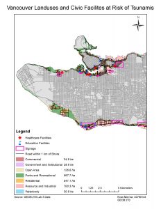
Finding the Total Vancouver Area at Risk
15.5% of Vancouver’s total area is in the risk area. To find this I created a buffer of 1km island from the shore, then from within that buffer I isolated areas less that or equal to fifteen meters above sea level. This area totalled to (20.3 square kilometers). I then did a simple calculation dividing the risk area by the total area of Vancouver (131.03 square kilometers).
Education Facilities Inside the Risk Area
- Education Facilities in danger
- Emily Carr Institute of Art and Design
- Institute of Indigenous Government
- Henry Hudson Elementary
- False Creek Elementary
- St. Francis Xavier
- Vancouver Montessori School
- St. John’s International
- Heritage 3R’s School
- St. Anthony of Padua-
- Ecole Rose des Vents
Healthcare Facilities Inside the Risk Area
- False Creek ResidenceVilla
- Cathay Care Home
- Coast West Community Home
- Broadway Pentecostal Lodge
- Yaletown House Society