Memo from an Environmental Assessor:
This memo accompanies a series of maps and will discuss their context, my role within the project, the results of the maps and my overall recommendation for the project going forwards. Through outlining the steps of analysis and the resulting information, this memo will highlight that redlisted ecosystems and the boundaries around fish-bearing rivers are the greatest environmental concerns for the project’s implementation.
What is the Proposed Project and Who am I?:
This series of map comes as a response to the BC Environmental Assessment Office’s statement in 2010 that the Garibaldi at Squamish project proposal lacked information on the potential effects of vegetation, fish, and wildlife habitat. These maps visually and spatially supplement the additional documents, which were submitted in April 2015, and may be used in ongoing discussions after the proposal’s tentative approval in January this year to show the extent of developable land. Specifically, as a Natural Resource Planner for Northland Properties and Aquilini Investment Group of Vancouver – the Garibaldi at Squamish project proponents – I intend these maps to be assist in the evaluation of the project’s priorities in order to proceed with the proposed year-round resort.
Method:
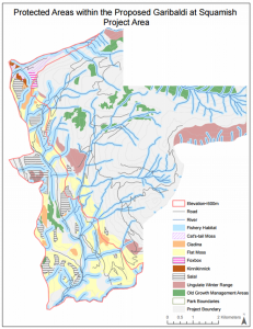
I combined spatial data from multiple sources in order to identify the total area impacted by environmental protections. I sought data for each concern item of missing information identified by the Environmental Office in 2010, compiling data on red-listed species’ habitats, old growth forest management areas, ecosystems (including biogeoclimatic, nutrient regime and soil moisture conditions), rivers, roads and elevation. Working with this data in combination with files delineating the scope of existing parks and the project’s proposed boundary, I created a single database and adjusted each layer so that is was referenced in a common 2D map projection form (in this case the Universal Transverse Mercator projection, Zone 10). The resulting compilation showed a map of all relevant environmental and topographical conditions within the proposed area boundary.
In order to identify the zones of concern, I first worked with the elevation model to identify areas below a suitable threshold for skiing, i.e. the area below 600m in elevation.
Adding to this constraint by considering the four dimensions of the local ecosystem’s fragility, I firstly dealt with the area of old growth forest that is under management, calculating the percentage of area that is covered in the project. Secondly, I used ungulate habitat data to map the sensitive areas of two species impacted by the project: Mule Deer and Mountain Goats. Thirdly, I used terrestrial ecosystem mapping data to identify the endangered, red-listed species’ habitats located within the project’s bounds. Biogeoclimatic, soil moisture and nutrient regime conditions indicate the existence of six redlisted species to be considered within the area: Falsebox, Salal, Cladina, Kinnikinnick, Flat Moss and Cat’s-tail Moss. These species were identified by finding areas that contained all of the necessary conditions for the most common red-listed ecosystems in the area.
Finally, I considered fish and fish-bearing streams in line with the BC Environmental Office statement. Streams above 600m are considered less likely to be fish bearing and, therefore, I considered their surrounding riparian area of concern to be smaller, only 50m. I created concern zones of 50m around rivers flowing above 600m. Below this elevation, the surrounding area of concern was extended to 100m with the greater likelihood of these streams being home to fish. By totaling the areas of these river protection zones, the total percentage of effected area of identified.
Results:
- Old growth forest: 3,710,332m2, representing 6.78% of the total area.
- Ungulate Winter Range: Mule Deer habitat covers 2,317,859.14m2 and Mountain Goat habitat accounts for 1,997,299.79m2, representing 4.24% and 3.65% of the proposed project area respectively. In total their habitats cover 7.87% of the proposed project area, or 4315158.93m2.
- Red Listed Ecosystems: in total redlisted habitats cover 13,584,529.76m2, or 24.84% of the proposed project area
- Fish protection: 15,555,960.43m2 of the land is effected by fish bearing stream protection areas, representing 28.43% of the project area
- Below 600m: The area of land below 600m is 17,394,027.82m2, representing 31.79% of the proposed site.
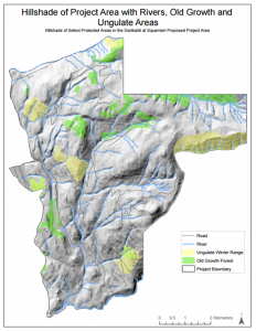
However, by merely totally these areas of ecological concern, a full 67.92% of the project area would be deemed of concern. Instead, by spatializing the zones, it is evident that many of these areas overlap, reducing the overall coverage of protected areas to a more reasonable 53.70%. When considering both the areas of ecological concern and the land below 600m elevation that is likely to be unsuitable for reliable skiing, the total area of concern is 32,630,898.44m2, or 59.64% of the total proposed area.
Two Greatest Environmental Concerns:
Breaking this total area of concern down by category, the two greatest environmental concerns affecting the project are fish habitat protection and the elevation of reliable skiing. The two areas represent the largest percentages of area. However, this project is intended to be a year round resort, meaning that the elevation of reliable skiing is not as important. Instead, the two greatest areas of concern are fish habit (28.43% of the total area) and red-listed ecosystems (24.84% of the project area). The river network in particular extends well beyond the suitable skiing elevation of 600m, impacting both summer and winter activity. The red-listed areas are largely concentrated below 700m in elevation and covering a lot of the land at this lower elevation, greatly impacting summer activity.
Ways to Mitigate Concerns:
These two concerns can be overcome through careful planning. To overcome these two concerns, and remembering the challenge of skiing below 600m elevation in the winter, I would recommend concentrating development on the land over 700m in elevation, beyond the extent of flat moss habitat. This will help to abate environmentalists concerns and increase resort profitability as services can be centralized in the least fragmented area. Secondly, in order to mitigate concerns from environmentalists, I would recommend creating a few major and well-signposted routes up to this higher elevation as customers and construction crews need easy access to higher elevations. The process of trail design through the low elevation area would benefit from engaging community consultation in order to continuing dispelling environmentalists fears and help in mitigating further social and heritage concerns.
Memo Reflection: My Own Ethical Stance
Although my memo suggested an acceptance of the proposal with only a few modifications, my personal reservations about the site are greater. I think a more holistic approach is needed to consider the impacts of the project beyond definable environmental zones, taking into consideration the pollution of operation, the emissions from transportation to the location and the environmental costs of construction. I also emphasize the need to consider impacts on First Nations communities – especially as the Squamish First Nation considers the mountain sacred – and the Squamish community – who have protected the development.
Yet, the project promises 2000 construction jobs, 4000 operating jobs and $49 million in tax revenue (Zeidler, CBC.ca, Jan 2016) and I do recognize the possibilities for the project to make as positive contribution. As the Squamish First Nation chief, Ian Campbell, highlights, the project has the ability to correct some of the past status quo with community involvement. For example, beyond the recommendation I make in my memo, the project could dramatically scale down its operations, it could explore environmentally-sensitive construction practices, or it could work with transportation authorities to reduce its emission externalities.
By making adjustments on this larger scale, I would be more likely to support the proposal as it addresses the preservation of economic stability, environmental quality and the existent Squamish community.