Looking at the census data, housing density has seen the largest increase in the northern most part of Fort McMurray. Much of this new growth is clustered together and is located in the WUI. In terms of median household income, the poorest areas have historically been in the downtown area, near the river. The new homes built in the north tend to have households with higher than average median incomes, presumably from incoming oil sands workers. There does not appear to be a visible relationship between proximity to the WUI and median household income.
The dissemination areas that suffered the most destruction (as a percentage of dwellings destroyed) were concentrated in the central region of Fort McMurray, close to where the wildfire first originated. Severely impacted neighborhoods include Abasand, Beacon Hill, Waterways, and the Centennial Trailer Park. Although the wildfire spread up north as well, not too many homes were destroyed the in Timberlea and Thickwood Heights neighborhoods.
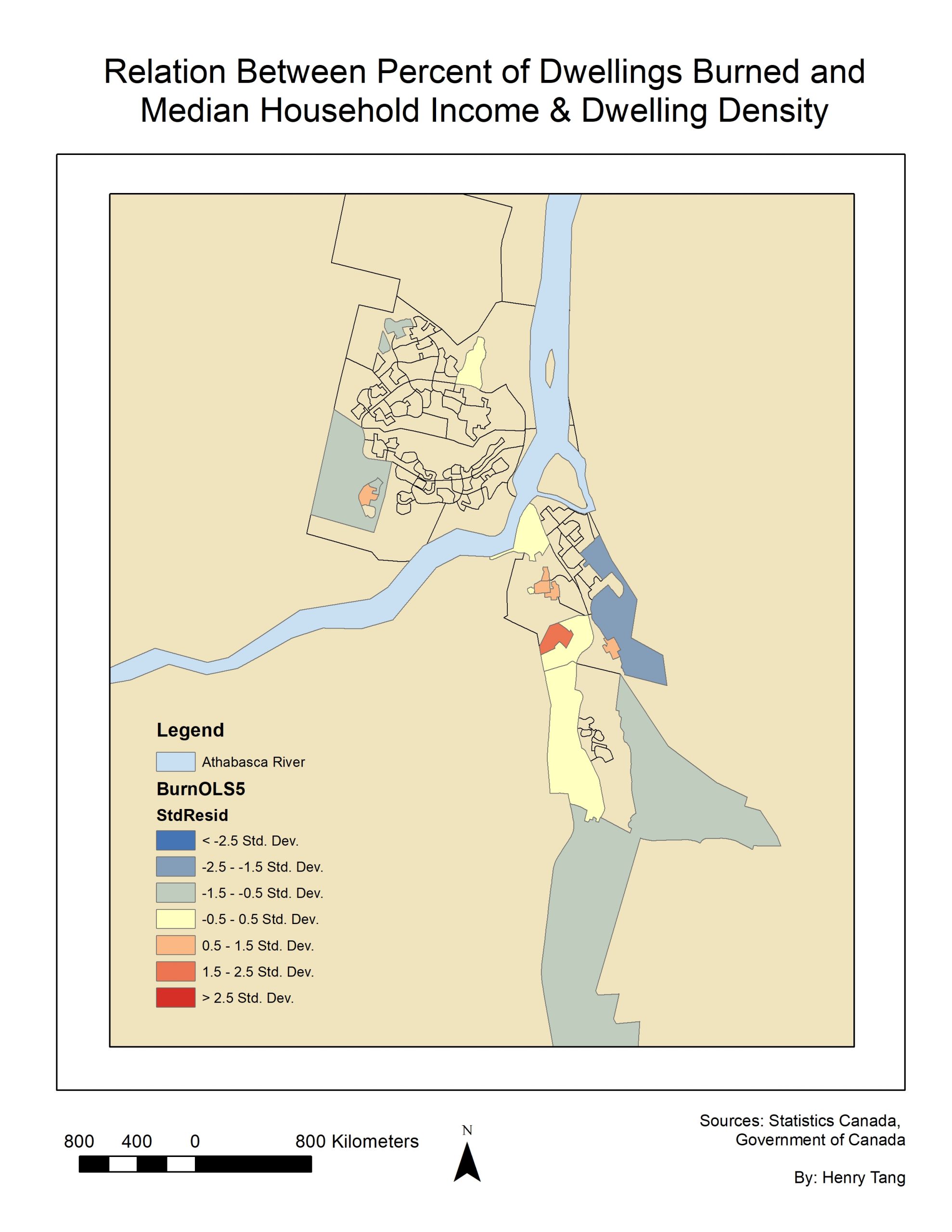
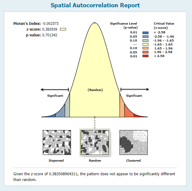
Pictured above are the results of the OLS regression that was performed. The downtown area is one of the highest risk areas with low median household incomes and high housing density, yet very few homes were burned in the area. In the neighborhoods that were hit the hardest, the observed values were significantly larger than the predicted values. These neighborhoods generally had moderate-to-high incomes and low-to-moderate housing density. As such, there does not seem to be a strong correlation between the number of homes destroyed and median household income and dwelling density. Applying the Moran’s I statistic to the regression indicates that the areas burned are not clustered together nor is there a spatial pattern between them.
The wildfire originated about 7 kilometres southwest of Fort McMurray and rapidly spread eastward towards the city at an estimated rate of 10m/min (MNP LLP, 2017). From there, it jumped the Horse River and struck the western border of the city before spreading across several neighborhoods the next day. It is clear that the fire largely avoided the downtown core of Fort McMurray , although the surrounding neighborhoods were severely impacted. Meanwhile, the fire also spread upwards towards the high income, densely populated neighborhood of Timberlea. The spread of the fire in this area was limited due to fire crews creating firebreaks between the forest and the neighborhoods as a defense mechanism (Thurton, 2017).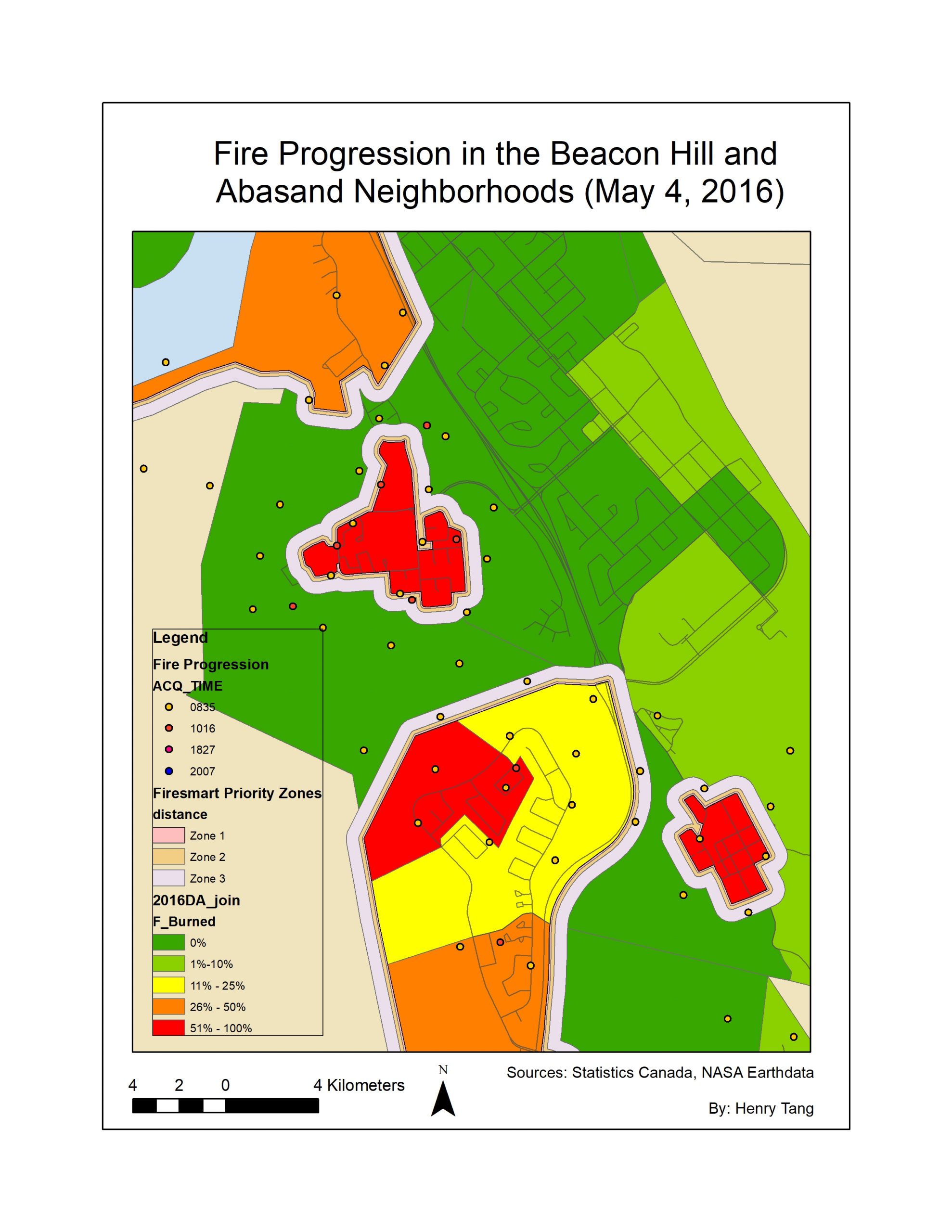 Looking at the multi-ring FireSmart buffers around the neighborhoods, it is clear that the fire reached the 100m and 30m priority zones and was not impeded by FireSmart recommended practices, instead continuing its destruction in direction of the houses. Furthermore, a study looking at why houses did and didn’t burn in the Fort McMurray Fire found that ornamental evergreen shrubs, an extremely flammable type of vegetation, were present on many urban lots (Westhaver, 2017). The before-and-after satellite images also show that many neighborhoods were either in close proximity to the forest or to urban green areas with no firebreaks. Wildfires can climb trees and turn into dangerous crown fires, from which embers can travel long distances and potentially ignite a nearby home. Although there were no direct casualties from the wildfire, with better preparation and fire management practices, many more homes could have potentially been saved.