“3] In order to address this question you will need to refer to Sparke’s article, “A Map that Roared and an Original Atlas: Canada, Cartography, and the Narration of Nation.” You can easily find this article online. Read the section titled: “Contrapuntal Cartographies” (468 – 470). Write a blog that explains Sparke’s analysis of what Judge McEachern might have meant by this statement: “We’ll call this the map that roared.” “
(Paterson, “Lesson 2:3”)
Maps are interesting items. We place a lot of trust in them, in their constellations of datum points and in the mathematical certainties of the Cartesian grid system. Given the nature of land claims cases, maps and geographical knowledge are of paramount importance. However, once maps become political, they are subject to interpretation, which is what Sparke explores in his article – specifically the power dynamics of these interpretations among different groups.
Why Sparke’s focus on this idea of a “map that roared” (McEachern, as quoted by Sparke, 468)? Sparke interprets this idea in two ways: one, as shorthand for McEachern’s derisive diminishment of the map presented by the Wet’suwet’en and Gitxsan; and two, using a deeper analysis to explore the tension between the borders of the nation-state and First Nations’ territory.
‘Roaring’ is an adapt personification here, as this map is “oral knowledge [translated] into a series of maps” (472). Sparke elaborates on this use of personification to show how this use of oral knowledge as territorial assertion is a radical act, with the aim of “playing the game in order to change it” (472).
For me the act of roaring is an assertive one, one that cuts through “the sheer density of the palimpsest produced by the whole series of precolonial, colonial, and postcolonial inscriptions” (474).
I think that this focus on the passing over of traditional knowledge and land claims by the judicial system speaks to what Sparke calls the “conventional tendency” for nation-state myth-making and map building. Sparke writes: “Nations, as it is commonly noted, tend thus to celebrate their supposed age rather than their remarkable youth” (479).
No where is this clearer than in the $10 million purchase of the 1507 Waldseemüller Map by the Library of Congress of the United States. The reason for this extravagant purchase? The Waldseemüller map is the oldest extant map that labels North America as America, an thus proof and celebration of America‘s (emphasis added) “supposed age”.
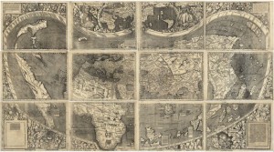
Waldseemüller Map (1507)
The Gitxsan and Wet’suwet’en map roars, by asserting the place of the Gitxsan and Wet’suwet’en people in the face of erasure. These maps assert their nation’s intimate ties to the land – a concept hard for those accustomed to “the silent, Cartesian, and decorporealized spatial codes of the modern western state” (474).
Maps like the one the Gitxsan and Wet’suwet’en produced are incredibly important, and are works of incredible labour. One of the great things about crowdsourcing and digital mapping is that efforts at mapping Indigenous land claims – such as those undertaken by the group Landmark – can be consolidated and easily accessed, another example of how the digital environment aids in expanding dialogue.
Are there any other instances where digital platforms have furthered Indigenous land claims?
Works Cited
Gitxsan Development Corporation. Gitxsan. Gitxsan Development Corporation, 2005. Web. 1 March 2016.
Hey Merriam,
I enjoyed your reading of Sparke’s article, and though I do not have any information regarding digital resources or platforms that further Indigenous land claims, I have worked to make (however rudimentary) maps of Sunshine Valley, where I grew up. Your post brought this to my mind, as it entailed myself, my sister, and a few close friends, hiking and sometimes taking the ATV up trails, over mountains, and further than we had ever gone before. It was one of the most rewarding and refreshing things I’ve done in my life, as our time spent allowed our small community to have a pretty clear understanding of the hiking available all over the mountains surrounding Sunshine Valley. Looking back, I can see my my actions somewhat mirrored those of the Gitxsan and Wet’suwet’en, apart from the significant fact that it was not my land I was on. Very interesting to think about, thanks again for your insight!
Nick
Hey Nick!
Thank you for your kind words! What an intriguing project you undertook mapping your Sunshine Valley. I would love to do something like that here in Winnipeg – an urban map tailored to how I live in this city, and one that speaks to my experiences.
Thank you for the inspiration!
Merriam
Hey Merriam,
Thank you so much for your blog post! I wrote about this topic as well (as you noted in your comment on my post haha). I thought the point you brought up about how maps and cartography are subject to immense interpretation. I think this is very crucial to shine light on because as you note, the power dynamics and consequent disconnect that arises from reading a map problematizes the ways in which its meanings are deciphered. In the case of McEachern and the Aboriginal peoples, the map proved to cause fear of the unknown– of the potential shift in power that the map could potentially bring about.
Upon reading Sparke’s exploration regarding this, I can’t help but wonder: would the same sort of reaction or response have resulted if the Wet’suwet’en and Gitxsan people had presented their claims to land in an alternate way? Was it strictly the fact that they outlined their desires in the form of a map that McEachern denied them? Was the reliance on cartography to articulate their claims what caused McEachern to deny them their desires? I think that while the cartographic tool may have heightened McEachern’s apprehension, the Aboriginal people’s claims to land would ultimately still be denied at that time. I could totally be wrong and that was kind of a big question, but I think it’s quite interesting to consider!
Thanks again for your post.
Neia 🙂
Hi Neia,
Thank you for your comment. I’ve spent the drive home thinking about your query – “would the same sort of reaction or response have resulted if the Wet’suwet’en and Gitxsan people had presented their claims to land in an alternate way?”. I’m with you, and agree that the land claim probably would have been denied no matter what at that time. The ruling against them, and the subsequent appeal and reversal of the original ruling is what set the precedent in Canadian Law for the validity of oral culture/history as evidence.
I haven’t studied Delgamuukw v British Columbia in any great capacity, and neither have I looked in depth into the resistance acts of the Gitxsan and Wet’suwet’en people after the original ruling in their land claims court case. I know that there was a significant amount of direct action via blockades. I’m wondering whether this direct action had any influence on the eventual Delgamuukw v British Columbia ruling.
While researching for this comment I came across Nettie Wild’s documentary “Blockade” which follows the 1992 Gitxsan Eagle Clan blockade actions. I haven’t watched it yet, but it’s definitely on my watch list!
Cheers,
Merriam
Hi Merriam
I really enjoyed reading your post! It’s always eye-opening to read peer responses to the same article, and I’ve gleaned much from yours. Your link to “LandMark” brought me on a fascinating journey to South Africa, Nicaragua, and Brazil, as I learned about ongoing projects around the world to provide maps and secure land tenure for Indigenous Peoples. What an amazing resource! I hope more people will have the chance to explore this website!
To answer your question, I’m not too familiar with digital platforms that have furthered land claims per se, but a little research on Google brought me to the Aboriginal Mapping Network (http://nativemaps.org/?q=taxonomy/term/90). Right on their home page is a fascinating map of the BC coast that overlays traditional First Nation land boundaries with a conventional political cartograph of the province. I think these images provide an interesting insight into the interface between western mapping ideas on one hand, and the complexity of aboriginal land use on the other.
Bea
Hi Bea,
Thank you for your comment! I checked out the Aboriginal Mapping Network, and it seems like an incredible resource. Thank you for pointing me in its direction! It was interesting perusing the page “What Brings You to The ANM?” and seeing what draws people to this resource. It seems like the AMN is not only a great mapping resource, but also a good networking resource, with people all over the world connecting over Indigenous land issues.
Cheers,
Merriam
Hi Merriam!
I’m reading through blogs to figure out who I want to team up with for the future conference!
I really enjoyed this post. I never really thought of the differentiation between using a map for navigational purposes and using a map for political purposes, so I was intrigued at looking into that more. I find it interesting how the Gitxsan and the Wet’suwet’en appealed to the “ways” of the British by presenting them with a map outlying the borders of their lands and the British still denied them. (I’m not saying Native groups did not create maps pre-colonization, I’m more comparing this to other instances where they openly denied assimilation to the British/Canadian systemic whiteness – and rightfully so! In comparison to these instances, the Gitxsan and the Wet’suwet’en were outright and obviously trying to appeal to the ways McEachern & those involved operated.) What’s even more interesting is McEachern’s response to the map, calling it “the map that roared”. The way I interpreted is that McEachern found the map threatening, so he tried to dismiss it by dehumanizing the Gitxsan and Wet’suwet’en people. After all, a roar typically comes from an animal, predatory in nature, such as lions, tigers, and bears (oh my!). When one of these animals feels threatened, it will roar to show its strength to its enemy. I believe that McEachern knew that the people of these groups felt threatened and they were using this map to exercise their strength and rights to their land. However, his simultaneous “othering” of these people by comparing them to dangerous animals made it so that they no longer needed to be taken seriously.
I’ve really enjoyed reading your blog posts & I’m interested in working with you for this upcoming group project! Feel free to peruse my blog and let me know what you think 🙂 (Also, I don’t have every assignment on there because I have been sick this semester, so please don’t think that reflects who I am as a student/group member!). Feel free to contact me through Facebook.
Hi Julia,
Thank you for your comments on my blog post. I appreciated your inclusion of your interpretation of McEachern’s comment “We’ll call this the map that roared”. Your interpretation of McEachern’s ‘othering’ of the Gitxsan and the Wet’suwet’en as animalistic in their assertion of the land rights is intriguing – it speaks to the views (of that time) placing of Indigenous people as of the land (as animals are of the land) – part of it, but with no real claim and thus subservient to the wishes of ‘stronger’ claims (those of industry and economics).
Thank you for reaching out to me regarding presentation groups! (I’m responding to this after-the-fact, and I look forward to seeing what you and your group will be presenting during the online conference! Best of luck!)
Cheers,
Merriam