1. Hazard Assessment
1.1 Proximal hazard zone and lahar distal zone
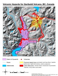
The district of Squamish is a highly hazardous region since it is close to near-volcano high-risk areas and is subjected to lahars. Lahars are known to cause significant damage to property and infrastructures. The results show that most lahars tend to flow to the southwest low land areas.
1.2 Ashfall zone

The 50 km ashfall zone proxy extends to the north and covers Whistler. Whistler is known as one of the best ski resorts in North America. Ashfall have been found to cause a range of adverse effects to human health such as irritations to the eye, nose and throat as well as coughing. Other than that, volcanic ash is also a hazard to aircrafts because it can cause multiple damages such as abrasion damage and instrument failure, as well as loss of visibility which can put many lives in danger.
Results of the Garibaldi volcano hazard assessment warrants the need for emergency evacuation plans for populations of Squamish and Whistler to avoid injuries and casualties associated with the volcanic hazards.
2. Evacuation Plan
2.1 Impacted Population Center
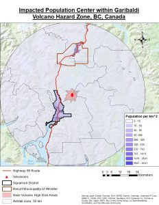
Only Squamish and Whistler are the two population centers located within the hazard zone. The other dissemination areas have extremely low population density. This suggests that there is a very low number of people living in rural regions.
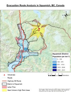
Squamish people should be prioritized for evacuation because there are lahar flows flowing across the district. Lahar is very likely to destroy the major highway (Highway 99) that connects Squamish with other regions. The people in Whistler are relatively safer than that of Squamish because they are farther away from the Garibaldi volcano and are only subjected to ashfall hazards.
North and Central Squamish are high-risked areas prone to lahars whereas the people in South Squamish are relatively safer and can quickly head down to the south via Highway 99.
2.2 Service Area Analysis
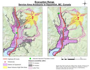
South Squamish is the safest in the district. Highway 99 within this area is less likely to be destroyed. The 15 and 20 min service areas generated from the north Squamish selected location show that the people would take more time to evacuate in the southern direction and are likely to encounter deadly lahar flows if they follow such path. It is therefore very risky for them to travel to Vancouver in the south and should instead head to the north. The second closest town that provides health care facilities is Lillooet. To escape the volcanic hazard zones, Whistler people should also head to Lillooet and avoid coming to Vancouver via Highway 99.
2.3 Evacuation Route Analysis
Highway 99 is very vulnerable to the lahars. Once some sections of Highway 99 is destroyed by the lahars, people will likely be trapped within the hazard zone. The evacuation route via Highway 99 will have high risks. However, by setting the lahar flows as a barrier in solving the fastest evacuation routes, there will be no available evacuation route since all the roads are blocked by lahars. This shows Highway 99 is the only major road that connects Squamish to other regions, and the same can be said about Whistler where its people also heavily rely on Highway 99 to connect to other nearby cities.
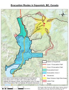
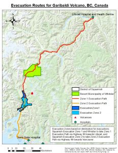
Taking into consideration both the service areas and lahar distal zones, Squamish was divided into two zones to ensure safe evacuation of the people in the northern Squamish who would take more time to head down south to Vancouver and have high possibility of encountering lahars while on their way to do so. Evacuation Zone 1 covers areas of northern Squamish whose population is recommended to follow Zone 1 Evacuation Path which follows Highway 99 towards Lillooet. On the other hand, Evacuation Zone 2 covers areas of central and southern Squamish whose populations are suggested to follow Zone 2 Evacuation Path which follows Highway 99 towards Vancouver. The population of Whistler is also suggested to follow the same path towards Lillooet to move away from the ashfall zone. The destinations are set to the closest medical facilities in the nearest towns, which are Lillooet Hospital and Health Centre and Lions Gate Hospital, to ensure any injuries associated with the volcanic hazards can be immediately treated.