The model verified results from previous studies that indicated an overall increase in the range of A. macrophyllum. It predicted a larger increase than those models of 75-100% by 2100. The modelled range for the base climate period was 500,947 square kilometers, which under moderate emissions increased to 831,826 square kilometers by the 2050’s, and 1,009,662 square kilometers by the 2080’s. There was not much variation between climate scenarios in the 2050 estimates, but the low emissions scenario had much less dispersal between 2050 and 2080, with a range estimate of just 853,051 square kilometers by 2080.

Increase in total range
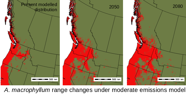
By mapping the spatial distribution changes, we can see where dispersal is likely to take place over the course of the century. The maps below show increases in range under the moderate emissions scenario. The model predicts that most dispersal will occur by the 2050’s, and is mainly at the eastern extent of the current range; through Washington,Oregon and parts of Idaho. Currently, these areas are drier and experience colder winters than coastal areas. We also see expansion northwards into central BC particularly along river valleys. There are other pockets of new suitable habitat modelled in the southwest US, however these areas are disjoint from the current range and may not be accessible by natural dispersal mechanisms. There were no decreases in suitable habitat within the study area, however the southern extent of the current range is outside the area considered, and there is a potential for habitat loss in southern California.
-
- Dispersal under moderate emissions scenario
-

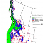
- Range increases in southern BC under moderate emissions scenario
-
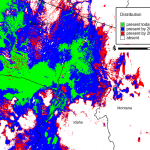
- Range increases in the northwest US under moderate emissions scenario