Digital Elevation Model
The first step in my project was to get the DEM for my area of study. Using the Index of DEM from the BC catalogue, I was able to get the correct DEM model which was 092G and 092J. Since the Index only allows the download of one strip of data at a time, I had to download over 30 strips of data and use the mosaic to new raster function to glue them together to make a DEM model.
TIN
To get the TIN data, I used the function Raster to TIN and set the DEM that I obtained as the input raster.
Slope and Aspect
Using the DEM data, I was able to obtain the slope by putting the DEM raster into the slope tool in the geoprocessing tab. Aspect was obtained using the same method.
Roads, Grassland/Shrubland, Water Bodies
Using the BC Catalogue, I obtained data on roads, grasslands, shrublands, and water bodies. For the road data, I first clipped it into our study area. I first selected attributes from the type of street, selecting “paved roads” and the major routes. For data on grassland and shrubland, separate shapefiles were obtained and clipped to the study area. Then, the merge function was used to combine grassland and shrubland. For water bodies, the clip function was used to clip to the study area.
Multi-Criteria Evaluation (MCE)
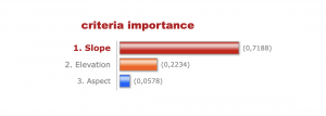
For the next step in the methods, I had to determine the relative importance of each variable. To accomplish this, I used an analytical calculator and divided our variables into 3 criteria: Slope, Elevation, and Aspect. From previous studies, slope is the most important factor when considering nesting locations. Then, the next in importance would be elevation, as nesting locations tend to be between 450 to 900 m. Then followed by aspect that is not as well researched as elevation or slope.
As calculated by AHP, the slope is given 72%, the elevation is given 22%, and the aspect is given 6%. Using the suitability modeler analysis tool in ArcGIS, we selected a continuous function for all our variable sets. For slope, I selected the MS Large function as I wanted slopes greater than 40 degrees to be more favorable. For elevation, I selected a Gaussian function to give higher scores to elevations between 450-900 m. By setting the midpoint at 675, the points close to that will get a better score. For aspect, since nesting areas prefer a south-facing slope, I set the midpoint at 180 degrees, allowing points close to the south to get higher scores. Then, using the locate function within the suitability modeler, I set the area to be 1000 hectares with 30 locations where nesting sites could be located. Each site had to be greater than 20 hectares. This gives a result in a raster, which I then converted to a polygon to get shapes for each of the sites.


