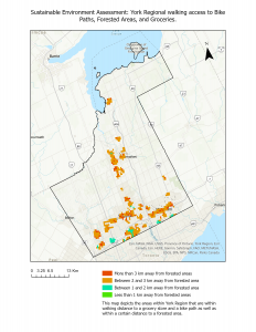
Two different sustainable environment maps were generated from the bike path, forested area, and grocery data layers. The first looks simply at only the areas that fall within the aforementioned buffer and close proximity class areas. When requiring the positive presence of all three community variables, the resulting qualifying areas are very limited. The map shows clusters around Newmarket, Markham, Vaughn, and Keswick. This is unsurprising as Newmarket, Markham, and Vaughn are the cities with the highest population density. It does indicate however that other smaller towns within York Region may be highly limited in terms of their ability to use non-automobile forms of transport to access quality nature and nutrition.
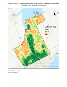
The second map produced with this data is a suitability map that accounts for almost all areas of York Region. The one area that very little data is available for is Georgina Island, a Chippewa First Nation reserve area. Rather than using the buffered layers for grocery and bike path access, the Euclidean distance tool was used to generate raster layers that could then be inputted into the Suitability Model tool. Setting the suitability to 1 for all areas beyond the previously buffered areas, and 10 for all areas within it allowed us to generate a suitability map that covered the entire York Region area. This map shows similar clusters of most suitable areas within Newmarket, Markham, and Vaughn. However, it also is able to describe with greater detail areas in yellow/ orange which may have 1 or 2 of the community indicators (largely access to forested areas and grocery stores).