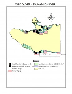
 In this lab, we found that 15.5% of Vancouver’s area is in danger should a tsunami occur that impacted areas of 15m elevation or less. We found this by finding the area of the Vancouvermask_Danger layer (20314735.555201 square kilometres) and dividing it by the area of the Vancouvermask layer (131033339.950334 square kilometres).
Using the Overlay tool, I created an intersect with the Vancouver_education layer and the Vancouvermask_Danger layer, and repeated the same with the Vancouver_health layer to find the facilities of these two types that would be in danger of a tsunami.
Schools in danger zone:
- Anthony of Padua
- Ecole Rose Des Vents
- Heritage 3R’s School
- Vancouver Montessori School
- False Creek Elementary
- Emily Carr Institue of Art & Design
- Henry Hudson Elementary
- John’s International
- Francis Xavier
- Institute of Indigenous Government
Health Care facilities in danger zone:
- False Creek Residence
- Broadway Pentecostal Lodge
- Coast West Community Home
- Yaletown House Society
- Villa Cathay Care Home