Categories
Uncategorized

Professional Development Reflection

As a student in the interdisciplinary B.Sc. Global Resource Systems program taking the urban sustainability track, I am interested in the intersection of environmental and social issues related to city design and impacts of urban life on our earth system. As this requires gaining both theoretical knowledge, gaining GIS skills has been a useful and exciting way to bridge information systems application with my urban studies and planning background to better understand, visualize, and make decisions on phenomena in both urban and natural environments.

Categories
Uncategorized

Flood Vulnerability Analysis in Miami, FL (Final Project)

  • Used resource management and census data sets and various ArcGIS tools to highlight municipal flood hazard areas for risk assessment purposes

See GEOB 270 Final Report for complete analysis and appendix

landusemap finalproject

populationmapfinalproject

Facilitiesmapfinalproject

Our GIS analysis aimed to identify areas of vulnerability from sea level rise based on 100-year flood zone projections to inform city infrastructure and emergency planners which coastal areas require attention and make further recommendations for adaptation. We narrowed our project down to three coastal municipalities in Miami Dade County and based our vulnerability criteria on affected population, valuable facilities and infrastructure (i.e., major roads, hospitals, sewer pumps, educational institutions, and ports) and in certain cases, measured losses based on map algebra.

Our team worked on all sections together. However two team members were more involved in downloading the data, the GIS analysis and representation, while other half of the team focused on the analysis findings, implications, and recommendations. We wanted to work together as a team on all project components as much as possible in order to keep track of all steps in the analysis be aware of potential errors, and ensure consistency throughout the map development. It is difficult in such a project to divide the work individually for the three parts of the analysis as a second person should verify the analysis is being conducted properly and minimizes error. We changed our approaches various times during the analysis process and debated which available data to use, so it was beneficial to have multiple members working on one computer at the same time. We used only two accounts to ensure easy data management and relied on an open data portal on Miami Dade’s official government website, which contained all layers needed for the analysis. For the actual report writing, we split up the results/discussion sections between two people, the error and conclusion section for one, and the flow chart creation between two people. Overall, this team worked very productively on the project.


Categories
Uncategorized

Planning a Ski Resort: Environmental Impact Assessment (Lab 5)

  • Conducted queries, proximity analysis, map algebra, and various other functions to  approximate the environmental impact of a proposed ski resort project, Garibaldi at Squamish
Contour map with sensitive habitat within proposed project area


3D hillshade of project area

Client Summary

The Garibaldi at Squamish project, which this analysis has covered, involves a proposed year-round ski resort location on Brohm Ridge. Tentatively, it includes 124 ski trails, 21 lifts, and associated resort accommodation and commercial development, with the ability to produce a total of 900 construction jobs in its 20-year building time frame and 2500 jobs during operation. As a natural resource planner, I have been tasked with reviewing the BC Environmental Assessment Office’s recommendation and the Resort Municipality of Whistler criticisms in order to determine whether the evidence is conclusive enough to oppose the proposed ski resort construction project. Thus, I have detailed below aspects of my ArcGIS analysis to conduct the environmental impact assessment that contributes to this evaluation:

  • Clipped layers (using ArcToolBox Analysis tool) to situate Ungulate Winter Range and Old-growth management areas within the proposed project boundary;
  • Categorized red-listed species from TEM layer using the Merge tool;
  • Distinguished between rivers above and below 600 m. elevation to determine high and low elevation areas;
  • Buffered low elevation rivers by 100 m. and high elevation rivers by 50 m, as low elevation rivers are more likely to be fish bearing, with multi-variable width buffer indicating fishery habitat;
  • Applied Union tool to combine old growth management areas, endangered fish species habitat, and red-listed species into a combined protected areas layer;
  • Applied the Dissolve function to avoid overlap and clipped the layer to the project boundary;
  • Erased this protected layer from the site to demonstrate areas to avoid for this project’s development.

According to the calculations, the percentage of the total project area that will directly impact protected areas, including old growth forest, ungulate habitat, and red-listed ecosystem, rounds to around 52%. 10.6% of the project areas is below 600 meters. 6.8% would affect old growth management areas, 7.8% would affect ungulates, and 24.8% would affect red-listed species. The two greatest environmental concerns regarding the development of this project include the effects to flatmoss habitat, a red-listed species. In addition, the project could affect fishery habitat within riparian areas. As these particular species would face significant impacts from the project, it provides enough reason to oppose the construction of the ski resort. After conducting a variable width buffer of 50 m. in higher elevation areas, and 100 m. in lower elevation areas, the calculations show that 26% of the area within the project boundary would affect fishery habitat. It would be best to mitigate effects in low elevation riparian zones as streams below 600 m. are more likely to be fish bearing. Flatmoss habitat is also mostly found in these low elevation areas. Therefore to mitigate impacts of the project, it would be best to avoid these lower elevation areas. Overall, as sensitive habitat comprises a large enough area of the proposed project site, plans for construction should be delayed or even dissolved until more environmental impact mitigation measures are delivered.

  • Ethical Considerations of Writing Memo for Proposed Project

Writing this memo led me to realize that conflicting opinions can stand in the way of making an environmental impact assessment decision. Personally, I believe that a huge project like a ski resort has systemic impacts, and so even if specific areas are perturbed by the project, other areas get affected in the landscape as well. For example, in my memo, it was suggested to avoid low elevation areas as these harbor more protected species. Nonetheless, even if higher elevation areas were built on for a ski resort, the upstream damage could trigger spillover effects downstream.


Categories
Uncategorized

Housing Affordability in Vancouver and Ottawa: Working with Census Data (Lab 4)

  • Classified census tracts in Vancouver and Ottawa using four major classification methods to analyze housing cost and affordability trends for each city and compare the cities based on these criteria.

I. Quantitative Data Classification

Depending on the application and audience, various GIS classification methods could be used. For instance, if given the task as a journalist to accurately compare the housing costs of two cities, Vancouver and Ottawa, in map form, natural breaks might work best, as it is the most accurate method of classification. However, as the distribution of housing prices of Vancouver stands in stark contrast from Ottawa’s, a real estate agent should consider using manual breaks. Whether this is entirely ethical is questionable, as it could be regarded by some as data manipulation.
HalinaLab4dataclassofficial

II. Methods for accurately communicating housing costs

Manual breaks is useful for comparing housing costs across two cities, as you can set the same values for the intervals,  see the prevalence of per value for each city and, for ease of understanding the legend. As shown in the map below, Vancouver demonstrates more cases of higher legend values whereas Ottawa census tracts mostly fall under lower legend values. Nonetheless, this classification method does not display the highly skewed housing cost levels in Vancouver.

HalinaLab4housecostVOofficial

III. Housing Affordability: Comparisons between Vancouver vs. Ottawa

Affordability measures the cost of housing normalized by median household income levels. Simply measuring housing costs does not mean anything for affordability, because household income levels could be comparable to housing costs and then, there would be no concern. However, in Vancouver, household income does not compare to housing costs, demonstrating an affordability issue. Thus, using affordability as a measure could have policy implications.

HalinaLab4affordabilityVOofficial2-2

Affordability is a very important indicator of a city’s livability. A city can have amenities and access to jobs, but if wages have not caught up with exorbitant housing costs this signifies an equity issue. Young adults and families as well as low-income individuals do not experience the ‘livable’ city the same way that those with high income earnings do. They are less likely to find adequate and conveniently-located housing. Vancouver has a reputation for third most livable city, but in reality, this is only for those earning higher income.

Categories
Uncategorized

Planning for a Tsunami (Lab 3)

  • Employed various Analysis Tools such as Overlay and Extract under ArcToolbox to create layers of health and educational facilities and road infrastructure, create summary tables, calculate statistics (area and length) for areas that would be affected by a tsunami
  • Indicated signage points (spatial and tabular data)  based on these statistics on a map to highlight Vancouver’s neighborhoods most at risk.

PlanningforaTsunamiMap

Through my GIS analysis for Lab3, I discovered that approximately 15%  of the city of Vancouver’s total area is at risk of tsunami damage. To arrive at this percentage, I went to ArcToolBox> Analysis Tools> Overlay> Intersect and created a layer called Vancouver_Danger from Vancouvermask (total land surface) and Danger (area affected by tsunami) layers to show the land surface in the city that would be in danger in the case of a tsunami. Under the attribute table of Vancouver_Danger, I took the total area value and then divided this by the area value for Vancouver Mask (also found in its attribute table) to get the percentage.

In addition, by using the same overlay tool as in the previous step, I combined the Vancouver danger zone layer with Vancouver health and education layers to find out the potentially tsunami-affected areas for the health and educational facilities. By visiting the attribute tables of each> Summarize, I created a sum table, and I found that the following health and education facilities in the city to be at risk of a tsunami:

Healthcare facilities: False Creek Residence, Broadway Pentecostal Lodge, Yaletown House Society, Villa Cathay Care Home

 Educational Facilities: St. Anthony of Padua, Ecole Rose des Vents, Heritage 3R’s School, Vancouver Montessori School, False Creek Elementary, Emily Carr Institute of Art & Design, Henry Hudson Elementary, Institute of Indigenous Government

Categories
Uncategorized

Working with Spatial Data (Lab 2)

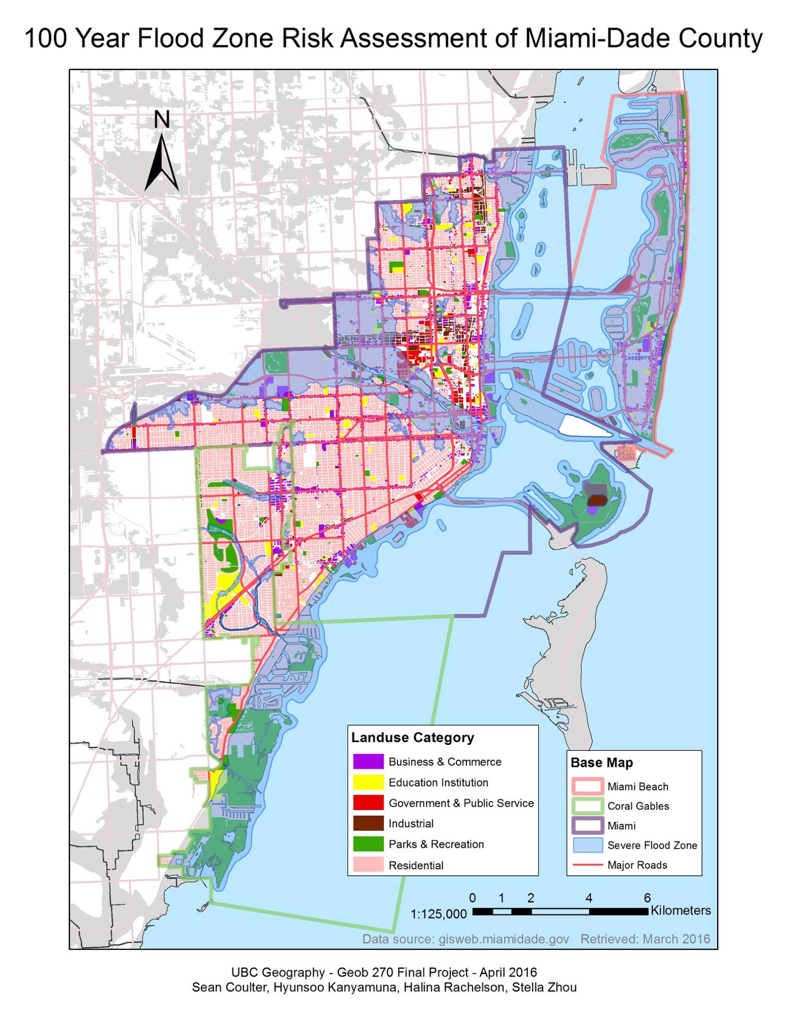
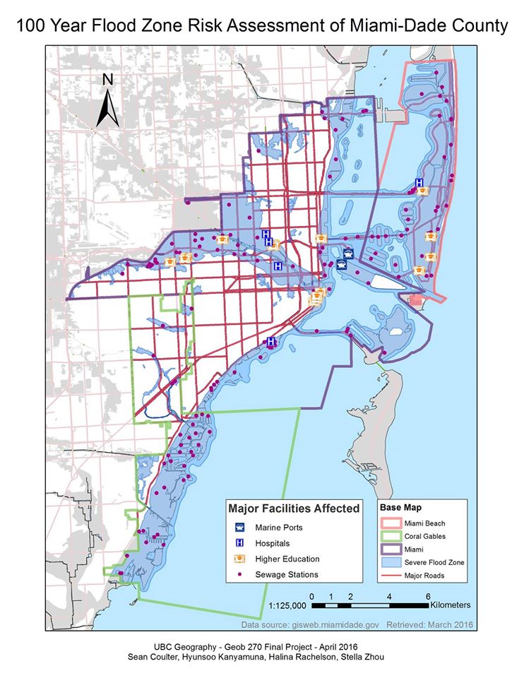
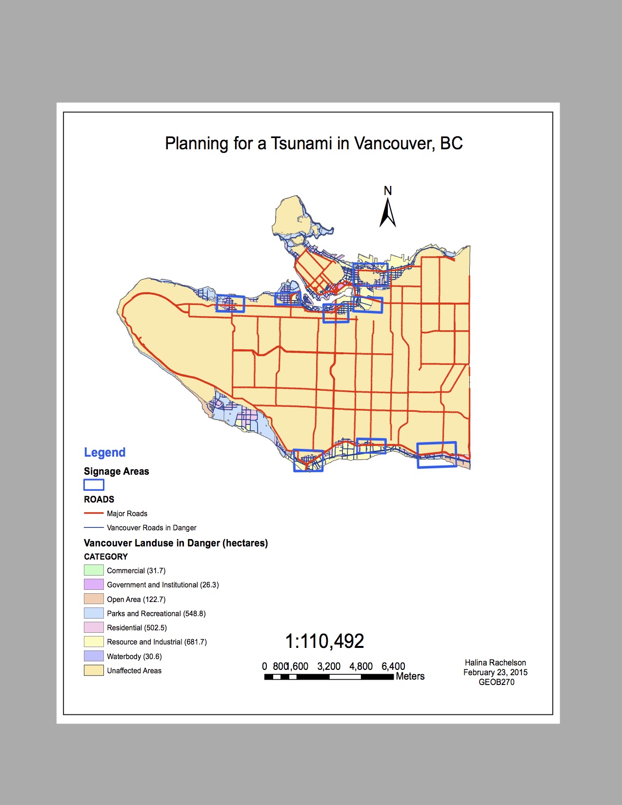
Properly Referencing Spatial Data 

Improperly referenced spatial data causes difficulty when data layers do not line up. To prevent this problem, it is always in good habit to visit ArcCatalog and right click each data layer to review the data properties before adding layers to Table of Contents for their display. You can review how the spatial data is referenced by examining right- clicking the data layer and selecting Properties. After the dialog box appears, the Spatial Referencing section can be found by scrolling down under the Source tab. This section provides important information such as the coordinate system, the datum, and the unit of measurement, which enables the GIS user to locate the data according to its proper geographic location on earth.

Often, different data layers contain different coordinate systems, depending on their features. This is usually not a problem, unless you have spatial information missing. However, an error box arises when the coordinate system of a particular data layer is unknown and you try to add the layer to the map. You would have to fix this manually to avoid misaligned data. First, it is essential that the Status Bar option under the View menu is checked. By right- clicking the data frame (the Group under which all the data layers are listed in Table of Contents), selecting Properties and finding the General tab, you can manually select the coordinate system. That way the features of the data layer can be located properly. If this error occurs again with another layer, it would be wise to review the metadata of the dataset, which can be found under ArcCatalog in the Description tab, for additional information or even contact the data provider for better data.

For geographic analysis, it is more convenient for data to be aligned under one coordinate system. Other ArcMap features, such as projection-on-the-fly, are useful. Projection-on-the-fly combines layers in different coordinate systems so they appear to align with one another, without requiring a change in the coordinate system. If you have most of the data layers for the map listed in NAD_1983 coordinate system, a geographic coordinate system, but one data layer referenced as Canada_Lambert_Conic, a projected coordinate system, you could delete the layer with the coordinate system that doesn’t match, in this case the projected coordinate system, find that layer and change its properties under ArcCatalog, so it is in NAD_1983 like the other layers. Then re-add the layer to the map.

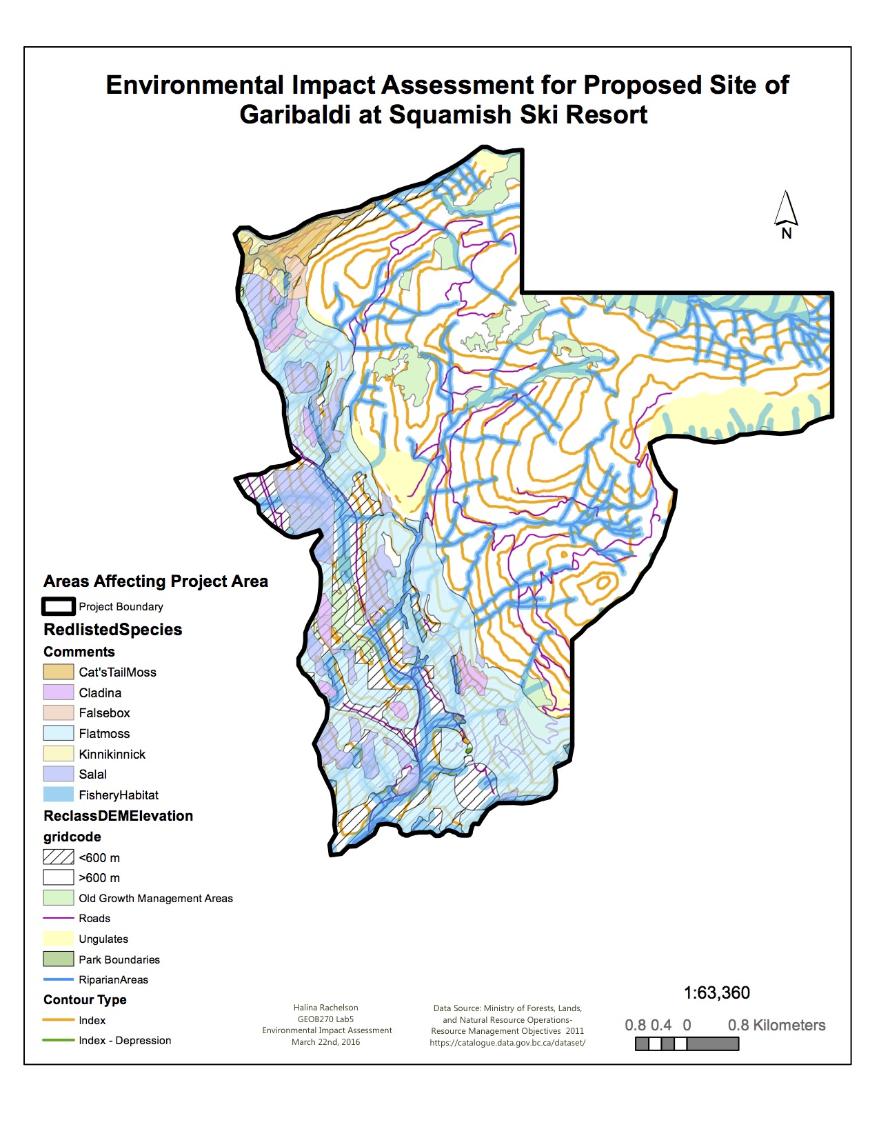
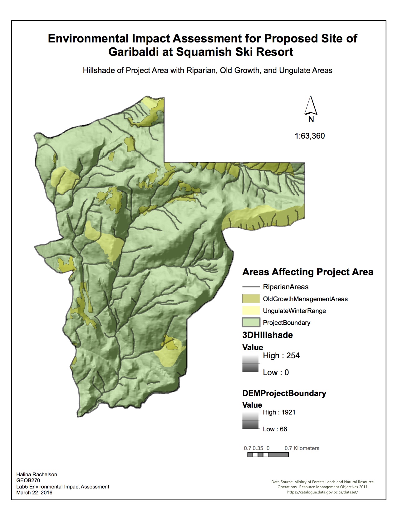
Remote Sensing using Landsat Data in Geographic Analysis 

Both remote sensing using Landsat and ArcGIS are useful for geographic analysis. However, when working with land use changes for resource management applications, rather than for planning and engineering applications in urban environments, Landsat data is very useful. Landsat is very applicable for monitoring large-scale geographic changes in the landscape. For example, it can display changes in the landscape (shoreline) before and after a volcanic disaster, changes in forest cover over a certain time interval, or indicate glacial melt through a receding shore line. This is because Landsat uses raster data, which makes it easier to visualize change. Data comes in the form of continuous data (mapped in contour form), such as precipitation, elevation, and land cover, rather than discrete features, such as individual lakes, road networks, and streets, which are displayed as vector data. You can monitor changes in a patterns over particular time intervals or see before and after effects to understand environmental change.

Categories
Uncategorized


Spam prevention powered by Akismet