
Ski Development Analysis
As a natural resource planner I will be in charge of evaluating the issues need to be addressed both major and minor issues at the proposed ski resort at Garibaldi Squamish Ski Resort. The proposed ski resort would provide economic benefit to the town of Squamish through tourism and commercialization. However, this ski resort could have potential effect on the wildlife and habitats that exist in the project boundary area. My goal is to assess the issues that could arise from the proposed ski resort take note of any considerable obstacles before the project continues.
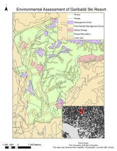
The two PDFs contained in this report has been created to establish the risk and feasibility regarding the construction of a winter recreational ski resort on the Garibaldi mountain in Squanish, British Columbia. This assessment is used to determine the impact and viability given the current wildlife presence in the area and the anticipated snowfall levels in the region
The assessment for the Garibaldi ski resort required synthesizing shape files on ArcMap.
Results
Using datasets provided by the province of British Columbia, we were able to predict the snowfall line at or below 600 meters using digital elevation, old growth forest, riparian management zones, and fish habitat zone files shape files. The proposed ski development at the Gibralti ski resort along with the proposed snow line at 600 meters will intersect a number of areas on the mountain, particularly the ungulate winter range, Fish habitat management zones. These areas must remain unobstructed as many animal habitats may be destroyed after the construction of the ski resort, resulting in declining fish and animal population. Furthermore, analysis of the contour lines at the ski resort run perpendicular to isobars in high pressure areas. These area often lay in the fish habitat zones and are vulnerable to construction areas that may threaten their survival. After compiling our data, we found that 32% of the proposed project zone is below the anticipated 600 meter snowfall line, making 68% usable for ski runs. The data shows that 7.89% of the project area will be immersed during the winter. Moreover, 6.78% of old growth management areas and 28.7% of the project zone is considered project management areas. In total, 38.9% of the total project area is considered sensitive. The environmental assessment office will certainly scrutinize this data since many riparian management zones cover a majority of the proposed resort zone leaving little useable land. It’s imperative that we take this data seriously however, climate change must be reconsidered when this data is used in the future. Therefore, I am confident that this data is accurate but this will change in the future as Earth continues to warm up.