For our last lab, we were conducting the environmental assessment on the project, Garibaldi at Squamish (GAS), a purposed year-round mountain resort located on Sea- to Sky Highway and it is 13 kilometers north of the district municipality, Squamish.

Memo – Garibaldi at Squamish Environmental Impact Assessment.
The site is 45 kilometers apart from the 2010 Winter Olympic site, the Whistler-Blackcomb resort and 80 kilometers to the region largest city, Vancouver. The resort will be including multiple ski lifts, ski pistes, resort accommodation, ground water supply system, infrastructure and other recreation facilities in the total project area of 2,759 hectares (GAS project Assessment Report, 2016).
As the natural resource planner for the proponent, Garibaldi at Squamish Inc., my duty is critical evaluate the concerns raised from our competitor, Squash Nation, and local residents. In this environmental assessment, the project area is primarily evaluated by the spatial analysis software, ESRI ArcGIS, and we have identified the potential environment aspects that may affect by the GAS in the project boundary:
- Rivers and fish habitats
- Old-grown forest area
- Red-listed plant species
- Ungulate habitats
At the same time, the analysis map indicates the area below elevation of 555-meter level which may consider as the bottom line for building ski resort in British Columbia according to a 1974 report. The area size for each aspect of environmental impacts also calculated as following statistics:
- Project area below 555m vertical: 1,637.74ha/ 29.94%
- Project area with river and fish habitats: 1,423.29ha/ 26.02%
- Project area with old grown forest existing: 371.03ha/ 6.78%
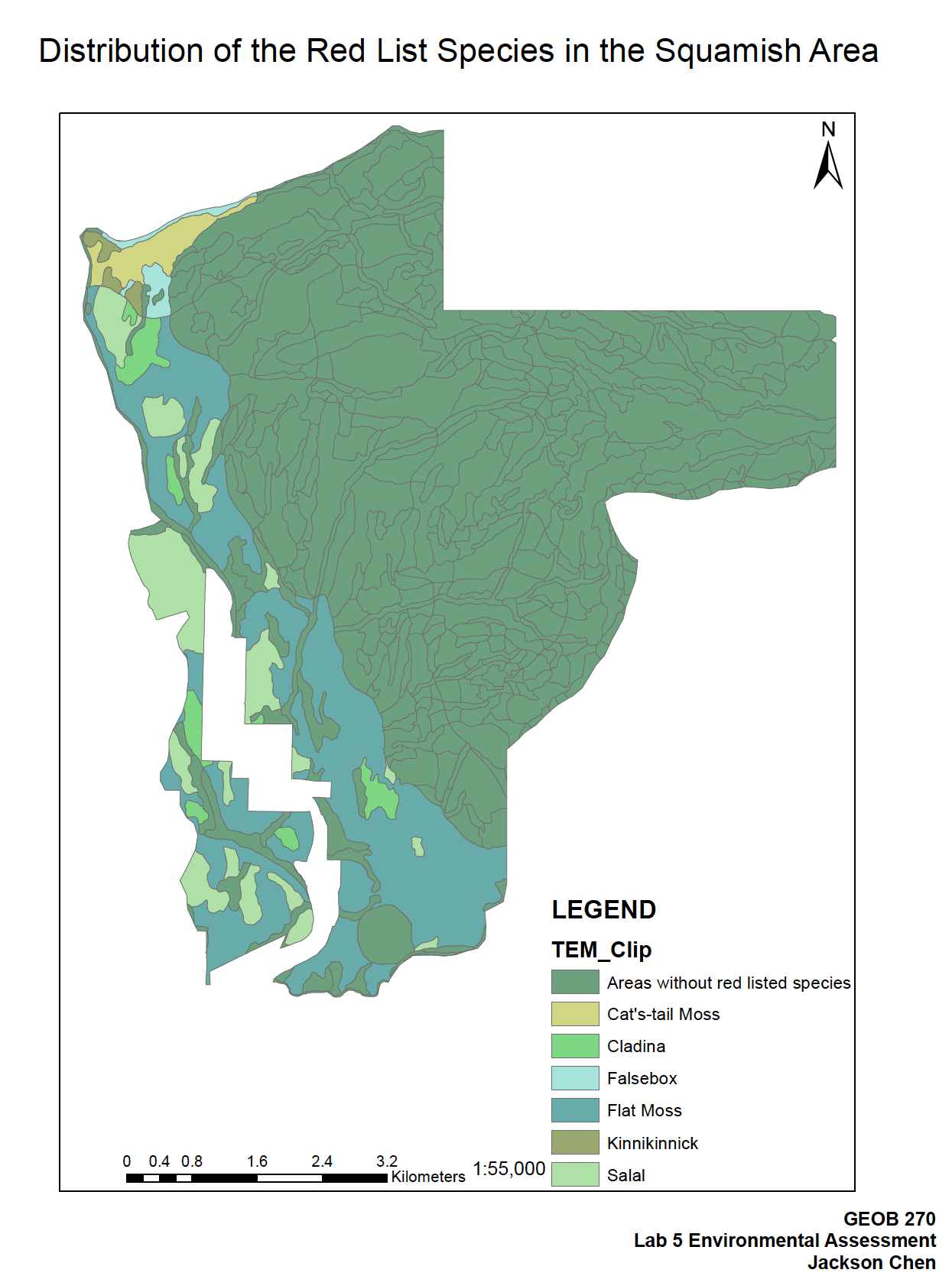
- Project area with red-listed species: 1,358.46ha/ 24.84%
- Project area with Ungulate winter habitats: 431.52ha/7.89%

Figure 2: Map of Red-listed plant species distribute within the project boundary.
The spatial distributions of each category have shown in above diagram. We can recognize that most of the red-listed species are grow adjacent to the main branch of the river that is located below the 555-meter line. The ungulate habitats are either close to the 555m contour line or on the project boundary. Although many small streams, headwater are scattered across the higher elevation, but there are less concerns for the fish species due to steep falls of streams which make it difficult for fish to swim back. However, the old grown forest sites are widely spread, their presences are more common toward the northern part of the project area. Base on evidences above, we have come up with few recommendations to guide the project planning in order to mitigate and minimized the impact on the local ecosystem. First, although the protected areas seem as big as the project area if we add up the percentage, in fact, there are about 52.65% is actually considering as the protected area because of the overlap. Secondly, the GAR should avoid constructing ski facilities and housing unit in the low elevation area (<555m). It will be more sustainable for the ski resort to build at higher elevation with colder environment, also place around the river basin is concentrated with vulnerable but significant ecological region and the developer must not disturb. When planning the ski runs, the proponent must agree not to develop the existing ungulate habitats and old-grown forest. Despite the head streams are usually small in scale, yet the proponent facility should avoid interruptions on the flows of water which is important for the main river’s influx.
In conclusion, the proposal project, Garibaldi at Squamish, should be approve by the government authorities. As the natural resource planner of the project, we had carefully assess the proposed land by conducting environmental impact assessment in the project area. Our construction will be refrain from ecological sensitive ground, for example, the existing protected areas and place below 555m according the E.A. result diagram.
As a GIS specialist, we may often receive some projects that we don’t ethically believe in but our clients require us to do our best for their benefits. These circumstances may be quite frustrated for some people, for example, when you working for controversial project proponents such as Woodfibre LNG project in Squamish and Kinder Morgan pipeline etc. In the workplace, when I involved in these proposals that I don’t match my personal believe or opinions, it is hard to tackle because we always constrained by the interests of the client. So in these cases, I may try to contact and pose some critical questions on the project while having the conversation with people from proponent side. If they demonstrated convincing evidence or solutions for the environmental concerns I raised, I will still stand on their side as long as the project does not show significant threats to the local community and involving illegal acts.
Reference:
Environment Assessment Office. ” Garibaldi at Squamish, Assessment Report” EAO Project Information and Collaboration (EPIC). Government of British Columbia, 21 Mar. 2016. PDF file


