While looking specifically at Surrey’s population density, land use or transportation network, was not an objective of this research project, I felt that it was important to look at these individual factors to better understand how they intersect and how a new bus route could fit into this existing network. Below you will find maps of these individual factors.
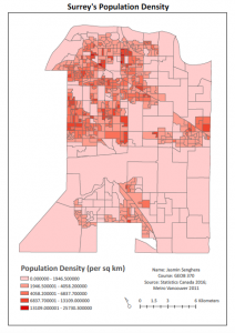
Figure 1. Surrey’s Population Density

Figure 2. Surrey’s Land Use Designations

Figure 3. Surrey’s Transportation Network
From producing these figures I concluded that the northwestern regions of Surrey (i.e. Whalley, Guildford & Newton) are the most densely populated, encompass land uses that are the most harmonious with a bus route, and have a large transportation network for buses to travel through as can be seen in Figure 1, 2, and 3. Therefore, looking at these maps prior to conducting my MCE analysis was a good way for me to gauge what kinds of regions would be ideal for a bus terminal.