When was this image collected?
09/03/2019
, Not Selected
03/09/2019
, Not Selected
28/08/2019
Results for question 2.
In your cloud mask, what pixel value indicates areas that should be masked in future analyses? What value indicates pixels to include?
Answer,
1 = Masked
1 = Included
0 = Masked
Answer,
0 = Included
Results for question 3.
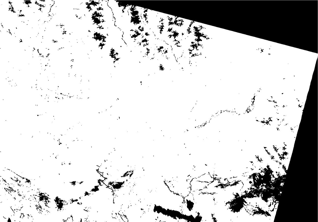
Upload a screenshot of your mask.
Correct
Results for question 4.
Are there any clouds or cloud shadows that are not masked by the pixel QA mask you generated? Are there areas that shouldn’t be masked that are masked? If so, describe these areas, and explain what do you think are the reasons for these discrepancies. In explaining your answer, you may refer to the documentation about CFmask in the surface reflectance product informationLinks to an external site..
Graded
There are several areas along the Fraser river where the masking mistook the white refelctance of islands along the Fraser to be clouds/snow. The areas that are discrepancies is based on surface reflectance which the island were similar to the clouds. According to the document about the surface reflectance, “CFMask may have issues over bright targets such as building tops, beaches, snow/ice, sand dunes and/or salt lakes.” In our case we see that the mask has trouble over beachers, and snow/ice on the mountaintops.
Results for question 5.
Define unsupervised classification. In your own words, describe the process of k-means classification.
Correct
Unsupervised classification, also known as clustering, is a machine learning technique used to group data points into clusters based on their similarities. The process of K-means classifcation is first to determine how many clusters you want, then randomly select centriod which will have points assigned to them. Then measure the distance between each point and each centriod and determine which point is in which cluster. Repeat using new centriods until no points can be moved around.
Results for question 6.
Why don’t we use Landsat 8 Band 1 as input for our classification? (If you’re not sure, do some research on the Landsat 8 band designations!)
Correct
Band 1 is useful for imaging shallow water and tracking fine atmospheric particles like dust and smoke. Band 1 is highly susceptible to atmospheric interference, such as scattering and absorption by gases and aerosols. This interference can distort the spectral signatures of surface features, making it less reliable for classification compared to other bands. Band 1 reflects blues and violets, where light is scattered by dust, smoke, and water particles in the air.
Results for question 7.
For each class (1-10), list the land cover type(s) that the class corresponds to (e.g. class 1 = forest, class 2 = developed, etc.)
Correct
Class 1 = Outer area of map where clip ends
Class 2 = Forest
Class 3 = Water
Class 4 = Forest
Class 5 = Water
Class 6 = Water
Class 7 = Forest
Class 8 = Fields/Agriculture/Golf Courses
Class 9 = Developed Urban
Class 10 = Snow
Results for question 8.
Upload your supervised classification image.
Correct

Results for question 9.
How many classes did your combined image have? What land cover types did these classes correspond to? Discuss the accuracy of the classification. What are the major errors/misclassifications that you observe? What do you think are the reasons for these errors? What land cover types does the classification seem to be particularly good at identifying accurately? Why do you think those cover types are easier for the classifier to separate?
Graded
The number of classes that my combined image had was 5 classes. These classes included Forest, water, agriculture, urban, and snow/alpine areas. The accuracy of the classification seems pretty good with some exceptions to parts that harder to distinguish. For example, some of the areas that had very white reflectance shows in the classification scheme as snow or ubran areas. The unspervised method is difficult to get just the right number of classes, too few means mixing real classes, and too many means it is hard to deal with. The land cover types that the classification seem to be particularly good at identifying is water bodies as it is has a way more distinct reflectance.
Feedback
Feedback from grader
relate all this to the spectral characteristics of the classes and the way the k-means algorithm works.
Results for question 10.
What are the classes that the k-means classifier identifies on the second image? Are these the same as the clumped classes you identified in Q9? Why or why not do you think this is the case? What classes seem to be the hardest for the unsupervised classes to separate?
Graded
The classes that the k-measn classifer identifed on the second image has the same classes as identifed in Q9. However, the classes has a lower accuracy then the 10 classes cluster. This is because we are not giving the algorithm enough classes to seperate all of the reflectance. The classes that seem the hardest for the unsupervising classes to seperate is urban and snow. The hardest classes for unsupervised algorithms to separate are typically those that exhibit high overlap, and complex relationships in their feature distributions.
Feedback
Feedback from grader
Can be stronger linked to spectral characteristics of pixel
Results for question 11.
Given the answer to Q10, how many classes would you recommend using in an unsupervised classification for the most informative results? Why?
Correct
I would suggest a 10 class unsupervised classification for the most informative results and then combine everything together using the combine tool . This is because 10 classes can sperate many things that the 5 class method missed for exmple brighter surface reflectance does not equal snow. Also 5 classes method does confuse a lot of the urban areas with argicultural land which in the 10 classes is more seperated.
Results for question 12.
For each class, report the number of polygons and the number of pixels you collected for training data.
Correct
Water – 10 polygons, 50000 pixels
Forest – 10 polygons, 12000 pixels
Low intensity – 11 polygons, 4000 pixels
High intensity – 10 polygons, 6000 pixels
Bare soil – 11 polygons, 500 pixels
Non-forest green veg – 10 polygons – 3000 pixels
Results for question 13.
Which classes are most likely to be confused with each other? Which pairs of classes are most separable? Report the spectral separability between these pairs of classes.
Graded
The most likely class that would be confused with each other would be the developed urban classes with low and high intensity. The most separable would be water and non-green vegetation. The spectral separability between low and high intensity is roughly 200 and the separability between water and non-green vegetation is 900.
Feedback
Feedback from grader
You can report here the actual separability between classes
Results for question 14.
Referring to your lecture notes, describe the procedure of maximum likelihood classification in your own words.
Graded
The maximum likelihood classification is where it assigns each pixel in an image to the class that has the highest probability of generating the observed spectral values for that pixel. Using the training data it sorts the pixels to each class using the spectral values. All pixels are classified.
Results for question 15.
Reflect on the initial results of your classification. What classes are most consistently classified correctly? What classes seem to be frequently confused with each other? What types of areas are most often unclassified? What do you think are the reasons for these patterns?
Graded
The classes that is most consistently classified correctly would be bare ground. The classes seem to be frequently confused with each other would be non-forest vegetation and forest. The most area that is unclassified is the Fraser River and the sea. There is just too many shades and each pixel of the river is different from the rest so it is hard for the classification to sort them into classes so most pixels go into the unclassified class. If I could of put more training data into the classification that could of made a big difference. The classification for bare ground is most accurate because the pixels for bare ground is relativley the same throughout the map.
Feedback
Feedback from grader
needs to be linked to spectral characteristics of pixels, and to the way the ML classification works.
Results for question 16.
What percent of pixels in your initial classification are unclassified? (To determine this, right click on your classified image in the Layer Manager, and click “Quick Stats”. The table at the bottom of the Statistics window will show you the percent of pixels with each DN value.)
37.92
Results for question 17.
What changes did you make (if any) and why (or why not)? How did these changes affect the quality of your classification and why?
Correct
I changed a lot of the training data to include more of the spectral reflectance pixels into the right classes. I tried to make more ROI of the water pixels in the Fraser River but when going to the classification it still doesn’t classify the water. These changes affected the quality of my classification by a lot as I got decrease the areas of unclassified pixels and changed pixels into right classes.
Results for question 18.
What percent of pixels in your updated classification are unclassified?
18.13
Results for question 19.
Describe the effect of the majority analysis on the appearance of the classification. How does this tool achieve that effect?
Correct
The majority analysis changes spurious pixels within a large single class to that class. You enter a kernel size and the center pixel in the kernel will be replaced with the class value that the majority of the pixels in the kernel has. The tool changes the appearance by earasing a couple of outlier classed pixels and cleans up the map in whole. The tool achieve that effect because the outlier pixel is replaced by the what the pixel around it is.
Results for question 20.
After the majority analysis, what percent of your pixels remain unclassified?
21.04
Results for question 21.
Upload a jpg image of the map of your maximum likelihood classified image.
Correct

Results for question 22.
Compare the results of your unsupervised and maximum likelihood classifications. Which do you think does a “better” job and why? (Explain what you mean by “better” in your answer) Why are there no unclassified pixels in the unsupervised image, but many in the supervised classification? What classes do the unclassified pixels correspond to in your supervised classification? How could you use the results from your unsupervised classification to improve the performance of your supervised classification?
Correct
The supervised maximum likelihood classification method does a better job. This is because although there are unclassifed areas in the supervised method, it has overall better classification in terms of classes and areas seperated based on pixels. In the unsupervised method pixels are assigned pixels based on similarity in spectral values. Since unsupervised classification does not rely on class labels, it categorizes all pixels into clusters, even if some clusters may not correspond to meaningful land cover or land use classes. As a result, there are no unclassified pixels in the unsupervised image because all pixels are assigned to clusters, but some clusters may represent mixed classes, or background information. In the supervised classification method, it uses training data to sort based on predefined class labels. The supervised classification algorithm may classify different pixels as unclassified or assign them to a class with low confidence, especially if the spectral signatures of the pixels do not closely resemble any of the training samples. Therefore the supervised classification method may have unclassified classes. With the results from unsupervised classification we could layer that on top of the supervised classification and see which areas that are unclassified in supervised corresponds to which in the unsupervised.