

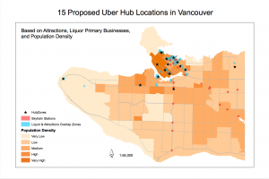
For the final project, our group decided to examine the placement of hubzones throughout Vancouver. Since later this year, Uber will possibly be officially launching in Vancouver, the purpose of our project is to locate 15 top optimal hubzones for Uber drivers. The purpose of the project is to locate ideal pickup hubs for Uber drivers based on population density, attractions, and liquor primary establishments.
Based on a set of conditions and restrictions, we were able to come to conclude 15 ideal locations for Uber hubzones to be implemented. In order to find our results, different datasets on activities, such as attractions, liquor primary establishments, as well as population density, were mapped onto a map of Vancouver.Through geospatial analysis performed on ArcGIS, we were able to conclude different trends that helped determine the placement of Uber pickup hubs. From our findings, we were able to determine a high population density in Downtown Vancouver, in positive correlation to the high density of liquor/bars and attractions present within the area. By taking into consideration of the following trends, our group was able to pinpoint 15 optimal Uber pickup hubs, which could accommodate attractions and liquor primary businesses. Through the project, it would also provide valid information for tourists in concerns about transportation accessibility throughout the city of Vancouver.
For our team management, everybody worked collaboratively in completing assigned tasks, working towards the final product. Considering the time frame we had to complete the project, everybody worked together on producing the final map during our lab times. With the final report, different sections were assigned to each team member in completing the report. As everybody finished their assigned roles, it was then combined together and edited between all members.
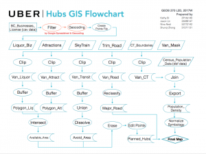
Through the project, I was able to come to learn new GIS analysis techniques. Without prior knowledge on how to compile/compress a excel file into ArcGIS, I was introduced to Google’s Geocoding platform, which essentially helped compress/ turn human readable addresses into geographic coordinates. With the geographic coordinates, it was then possible for ArcGIS to pinpoint and map locations onto our maps. Also, through our project, I was able to come to learn that not all the data we wished to include within our map could be found publicly. Various data sets that we wished to portray on my map instead were to be found on private platforms, denying us access to encompass the shape files.
The full project report can be view here: GEOB270-Final-Project-Report-WED5