Assignment 5 – Map Deconstruction

The Institute for Economics and Peace, a self-described ‘think tank’ that analyzes conflict and its economic costs and conversely the economic impacts of peace, produced this map of their Global Peace Index: http://www.visionofhumanity.org/#/page/indexes/global-peace-index

The data source and parsing and filtering is quite clear. Their peace index is compiled from 23 different metrics, all of which you can display individually and each one has a data source. For some of the individual metrics it gives more insight into the data parsing and filtering process. For example, some are “scaled from 1-5” whereas some show only the data source.

The intention of the map is to visually convey the findings of their 2016 Global Peace Report, a comprehensive report evaluating the state of conflict globally, specifically displaying their Global Peace Index. The ranked countries are then further divided into 5 categories ranging from ‘More Peaceful’ to ‘Less Peaceful,’ depending on their ranking, and displayed using a divergent colour scheme. The audience of this map is likely to be the public as this organization works with media.

There are no obvious and immediate biases. However, in terms of deconstructing this map, I think there is a lot of fodder here. While this map is called (arguably euphemistically) a Global Peace Index, this map can also be interpreted as, ‘this is how safe each country is’. This is not shocking because this rhetoric is incredibly common these days. One interesting aspect of this map is that you can move the visualization back through to 2008. This is unsurprising, given the increased focus on terrorism and international security since that time. Another interesting thing we can analyse in a deconstruction is how long these Global Peace Index reports have been produced. A cursory look shows that this organization has been producing them since 2011. I think this gives additional information. Whether it represents a time lag or an uptick in global insecurity at that point in time, would require a more in-depth analysis than this one, but it is worth noting. As Harley says, “Rhetoric may be concealed but it is always present, for there is no description without performance” In this case, the production and the conditions surrounding the production of the map are relevant in the map’s message, although we may not immediately considering in a cursory reading. It is something that we take for granted.

Along those lines, there are also more direct cartographic choices that we can deconstruct. The first is perhaps a more obvious bias and a common pet peeve of geographers everywhere and this is the use of the Mercator projection. We have established this map directly addresses safety, which is a very basic concern and taps into people’s fear quickly. In the Mercator projection, size is grossly exaggerated close to the poles and here we see how threatening this is looking at Russia, ranked 159 out of 161, and an imposing red colour. I personally feel a tiny surge of fear looking at this. I doubt this was deliberate, because in web mapping, the Mercator is still widely used, but it is possible. I would have chosen a different perspective.

Overall, this map is very good. They are very clear about where their data comes from, though they are not entirely transparent about their process. I would certainly change the projection if I were producing this map, but I think it is well done and justified in any biases.

Assignment 2 – Animation Using Processing

Original Proun Image:

proun1

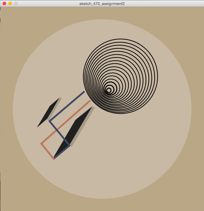
Replica of Proun Image:

screen-shot-2016-09-27-at-1-30-12-pm

The code for my replica:

  //canvas setup
  background(186, 167, 133);
  size(700, 700);
  fill(182, 160, 128);
  
  //middle brown circle
  noStroke();
  fill(200, 185, 165);
  ellipse(350, 350, 614, 614);
  
  //float variables for ellipse size
  float h = 255;
  float x = 413;
  float y = 238;
  
  //concentric circles 
  stroke(1);
  strokeWeight(2.5);
  noFill();
  //'for loop' for concentric circles
  for (int i = 0; i < 18; i = i+1) {
    if (i > 13) {
      stroke(1);
      strokeWeight(3.5);
      noFill();
    }
    ellipse(x-2.5*i, y+3*i, h-15*i, h-15*i);
  }
  
  //black shape - large
  stroke(33, 32, 32);
  fill(33, 32, 32);
  quad(259, 388, 187, 510, 237, 472, 310, 347);
  
  //black shape - small
  stroke(33, 32, 32);
  fill(33, 32, 32);
  quad(171, 340, 198, 317, 159, 382, 132, 405);
  
  //grey line - large
  stroke(166, 153, 136);
  strokeWeight(10.0);
  strokeCap(SQUARE);
  line(241, 476, 320, 343);
  
  //grey line - small
  stroke(166, 153, 136);
  strokeWeight(8.0);
  strokeCap(SQUARE);
  line(163, 388, 207, 311);
  
  //pink lines
  stroke(189, 117, 93);
  strokeWeight(6.0);
  strokeCap(SQUARE);
  line(185, 523, 140, 467);
  line(138, 470, 309, 320);
  
  
  //blue lines
  stroke(64, 72, 98);
  strokeWeight(6.0);
  strokeCap(SQUARE);
  line(289, 289, 169, 391);
  line(167, 389, 239, 476);
  line(238, 474, 185, 518);

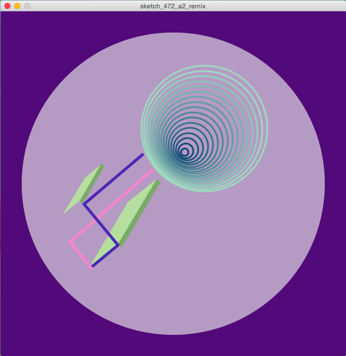
Remix of Proun Image:

screen-shot-2016-09-27-at-1-29-39-pm

My code for my remix:

//canvas setup
background(82,10,122);
size(700,700);
fill(182,160,128);

//middle light purple circle
noStroke();
fill(181,155,196);
ellipse(350, 350, 614, 614);

//float variables for ellipse size 
float h = 255;
float x = 413;
float y = 238;

//Float variables for ellipse colour 
float r = 157;
float g = 218;
float b = 191;

//concentric circles
stroke(r, g, b);
strokeWeight(3.5);
noFill();
//'for loop' for concentric circles
for (int i = 0; i < 18; i = i+1) {
  ellipse(x-2.5*i, y+3*i, h-15*i, h-15*i);
  stroke(r-10*i, g-10*i, b-5*i);
}

//green shape - large
stroke(182, 223, 159);
fill(182, 223, 159);
quad(259, 388, 187, 510, 237, 472, 310, 347);

//green shape - small
stroke(182, 223, 159);
fill(182, 223, 159);
quad(171, 340, 198, 317, 159, 382, 132, 405);

//dk green line - small
stroke(122, 170, 105);
strokeWeight(8.0);
strokeCap(SQUARE);
line(163, 388, 207, 311);

//dk green line - large
stroke(122, 170, 105);
strokeWeight(10.0);
strokeCap(SQUARE);
line(241, 476, 320, 343);

//pink lines
stroke(247,132,207);
strokeWeight(6.0);
strokeCap(SQUARE);
line(185, 523, 140, 467);
line(138, 470, 309, 320);

//blue lines
stroke(74,41,181);
strokeWeight(6.0);
strokeCap(SQUARE);
line(289, 289, 169, 391);
line(167, 389, 239, 476);
line(238, 474, 185, 518);


Personal Statement

The rate at which we interact with spatial data is increasing, and the applications are far-reaching. I am interested in the applications for spatial analysis to display how we interact with space, and to inform decision-making at various scales, from which running route is the best, to large-scale conservation decisions. I am interested in how spatial patterns are conveyed and the potential for open-source spatial data to contribute to decision-making.

Accomplishments II

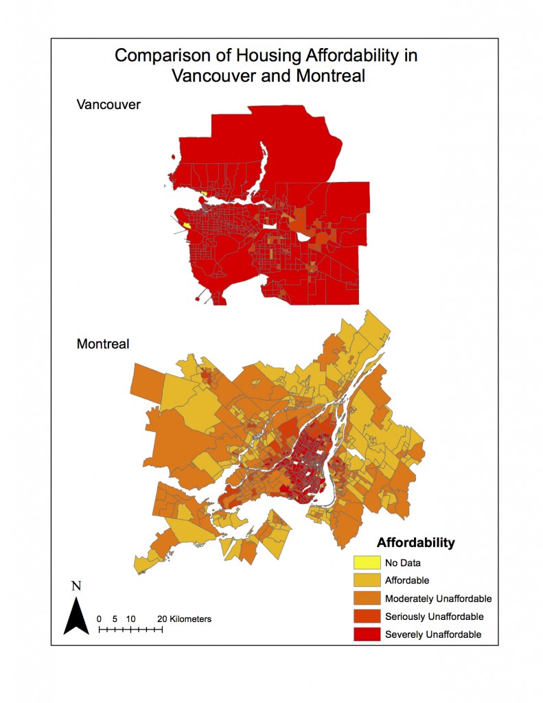
In lab 4, I produced maps comparing housing affordability in Montreal and Vancouver, by joining census data to spatial data and dividing income and housing cost into classes.

In lab 5, I assessed the environmental feasibility of a proposed ski resort project, by compiling various data on climate, protected areas, and requisite stream buffer zones.


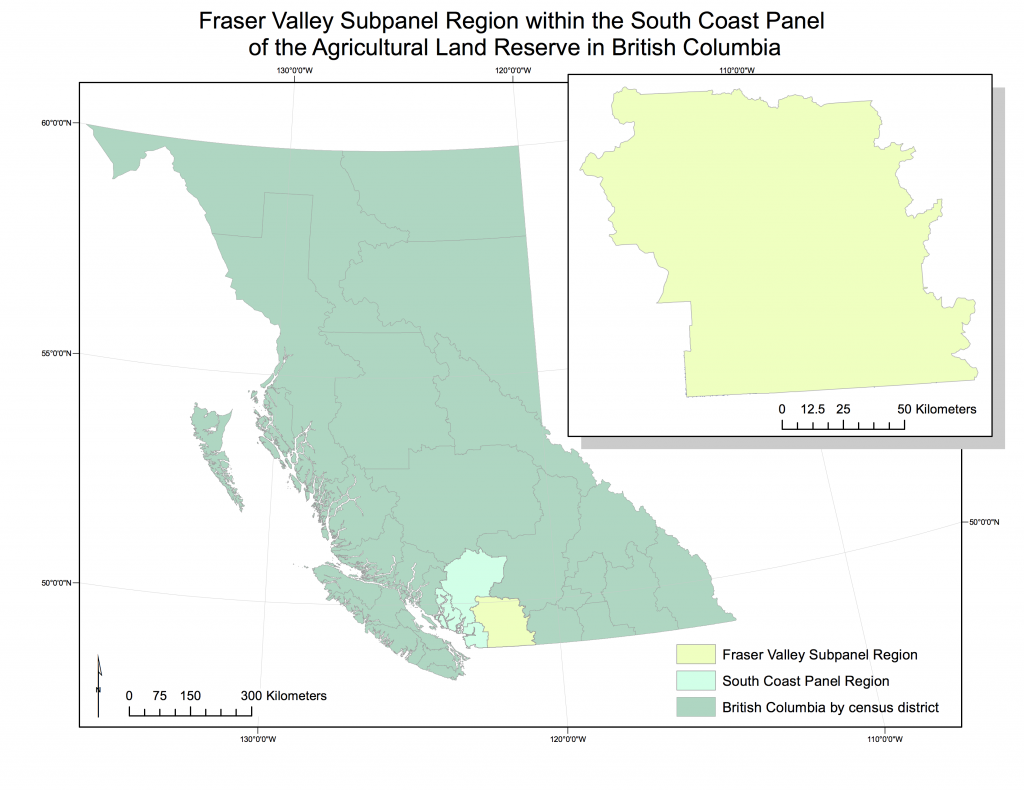
Final Project – Agricultural Land Reserve of the Fraser Valley Region

fvsubpanel_contextOur project goal was to determine the current availability of land for that is prioritized as agricultural use in the Fraser Valley subpanel region of British Columbia’s Agricultural Land Reserve (ALR), and any potential threats to the current reserve area.

Our team was comprised of myself, and Alexandra (Ali) Harris. We kept written work on Google Docs, and stored data in iCloud. We referred to our flowchart throughout, and stayed in communication regularly through text and email.

We worked closely on the project, with Ali keeping track of our data sources and writing the final report, and myself creating an organizational system for spatial data, performing analyses in GIS and creating the maps.

Having spent most of my life in urban environments, I am never really required to think about agricultural land. Learning that the ALR exists in British Columbia was interesting. At its core, prioritizing food security is counter to how space is generally, and particularly in Vancouver, managed and monetized. Space comes at a premium, and its monetary value is generally at the forefront of discussion. To have a system in place that prioritizes food security is heartening. The geography of the Fraser Valley made it interesting, in terms of proximity to BC’s largest urban centre (and market) and in terms of arability. The Fraser Valley region is already very productive agriculturally, and as a result, economically productive. This thriving region is being encroached upon by the growing population that it supports and urban sprawl and development, due to growth in the Greater Vancouver Region being bound by a border, an ocean, and a mountain range.

I greatly enhanced my familiarity with GIS, particularly the importance of projections. I found the most interesting part of the analysis was creating joins between tables in order to refer the census data to the spatial data.

Ali and I were fortunate because we have a similar schedule, which reduced our need for management, per se. Separating management of the writing and the GIS components was useful.

Initially, we did not have a good data management system, so I had to reorganize all of our datasets. This made everything much clearer and the lab and when I re-imported onto the lab computer, I had a much better understanding, and found the data were much easier to work with.

There could be potential issues with data that are publicly available, such as misappropriation, manipulation, or simply misuse. For this project, for example, a housing developer could extract look at census data and easily manipulate the population to appear larger in the Fraser Valley region, thus putting pressure on the province to release ALR land for new developments.

lab 5

lab5

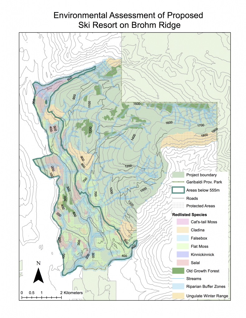
I am a natural resource planner retained by the British Columbia Snowmobile Federation (BCSF) to evaluate their opposition to the Garibaldi at Squamish Project, a proposed year-round destination mountain resort on Brohm ridge, between Squamish and Whistler. The project has been through a long consultation process (since 1997), and has drawn criticism from the Resort Municipality of Whistler, as well as the BCSF. I will conduct an assessment of the potential environmental impacts in order to evaluate whether the continued opposition of BCSF to the project is supported with evidence, or whether the environmental impacts can, in fact, be mitigated and BCSF can withdraw their opposition.

The most obvious feasibility criterion for a ski resort is the presence of snow. It has been proposed that, in this area, there is no significant snowfall accumulation below 555m. So using a digital elevation model, I first reclassified what areas within the proposed project boundary were below 555m, finding that a total of 29.9% of the proposed area is below that elevation.

The second consideration for feasibility was land use, specifically, protected areas. In this study, I calculated the percentage of area the proposed area that is occupied by designated old growth management areas (6.8%) and over-winter ungulate habitat (7.9%.)

Additionally, I wanted to investigate what red-listed (i.e. endangered or threatened) vegetation could be found within the proposed boundary, and how much area would be occupied by the riparian buffer zones necessary around all streams.

Using Environmental Resource Management Ltd.’s assessment of terrestrial ecosystems, I isolated the red-listed ecosystems based on site series (soil conditions) and biogeoclimatic unit, finding 6 threatened species, which occupy 24.2% of the total proposed area.

To identify riparian and stream areas, I had to create a variable width buffer. Streams above 555m elevation require a 50m buffer, while streams below 555m require a 100m buffer, because higher elevation streams are considered to be less likely to be fish bearing. These combined stream and riparian areas occupy 30.1% of the total proposed area.

In order to determine what percentage of the total proposed area is protected without any overlap, I combined each of the four aforementioned map layers, old growth forest, ungulate winter habitat, red-listed species, and riparian and stream areas, and I calculated the total area. I found that 55.5% of the total proposed area is designated protected. Without removing any overlapping areas, the total percentage of proposed area that is protected is 69.1%, so 13.6% of the protected land is protected under two designations.

Further, I found that 29.9% of the area is below 555m, or outside of a significant snow accumulation area (although much of this does overlap with the protected area.) It seems that in order for this project to go ahead, there will be compromise, either of protected areas, or with respect to project development, both.

My main concerns regarding the environmental impacts of this proposed project are fish habitat and red-listed ecosystems. Presuming that, due to lack of snowfall, skiing is limited to areas over 555m, it would seem logical that resort and commercial development would take place at those lower elevations within the park boundary. These areas are dominated by red-listed species, and the streams in these lower elevations are also considered more likely to be fish bearing. Generally speaking, the preservation of wide swaths of vegetation and riparian zones is in direct opposition to commercial development. I do not see great potential for mitigation of these concerns, unless the developers were willing to market on the basis of preservation and environmental conscientiousness, in which case, development particularly of resort and commercial use areas would have to be greatly limited, and it may not be economically viable for the developers.

I do not think the project should continue. Personally, I believe that with over 50% of the proposed area already designated as protected, there is no reasonable argument for going ahead with the project. Additionally, as someone who takes advantage of the myriad recreational opportunities already present in the area, I would hate to see it become similar to Whistler, which is just not the experience I look for when heading outdoors. This doesn’t differ from what I wrote in the memo, but it is possible that my bias was influencing my write-up, but (luckily) I think the environmental evidence does support my argument.

housing affordability


affordabilityVM

Affordability takes into account not only housing cost, but the ratio of median house price divided by gross annual median household income. This is a better indicator of affordability than housing price alone because it normalizes the housing prices by incorporating income, allowing comparison between cities.
The ratings of affordability are:
Severely Unaffordable – 5.1 & Over
Seriously Unaffordable – 4.1 to 5.0
Moderately Unaffordable – 3.1 to 4.0
Affordable – 3.0 & Under

The rating system is based on the “Median Multiple” described above, which is the agreed upon method of determining affordability and is widely used internationally, including international organizations. The fact that this method is widely agreed upon to be the best and it is used by large international organizations, it is safe to assume the data is “trustworthy.”

Affordability is a good measure of a city’s livability. If you can’t afford shelter, then livability will be highly compromised. Shelter is one of the most basic needs we have in life.

lab 4

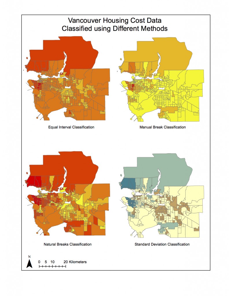
Lab4Question7If I were a journalist assembling these maps for a story on housing cost, I would probably choose the equal interval classification method, because it really looks the direst, and that might be a more interesting/outrageous story. It definitely depends on the angle I am going with for my story. If I were trying to argue that Vancouver should be considered less “liveable” I would certainly go with equal interval.

If I were a real estate agent, on the other hand, I would use the natural break classification method. Although housing prices around UBC look higher relative to other areas, it does appear that there is some relatively affordable housing, and the situation does not look quite so dire.

There are certainly ethical implications in choosing a classification method. Data interpretation and visualization is a very subjective process, and with that there is the potential to influence the data with personal biases, and often those biases are not necessarily clear to the person viewing the final product.

lab 3

11922151_lab3
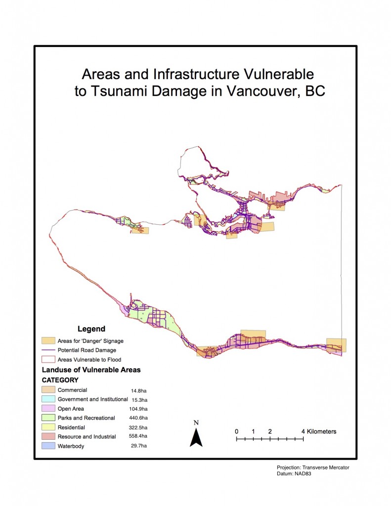
11.3% of Vancouver’s population is vulnerable to damage should flooding occur. To find this percentage, in the attribute table of the ‘vulnerable’ layer, I looked at the statistics of the ‘Shape_Area’ field and used sum to find the area in danger = 14862774.114046m2
I did the same process to find Vancouver’s total area: 131033339.950334m2
I divided the vulnerable area by total area and multiplied by 100 = 11.3%


Health facilities:
False Creek Residence
Villa Cathay Care Home
Broadway Pentecostal Lodge
Yaletown House Society

Education facilities:
Emily Carr Institute of Art & Design
Henry Hudson Elementary
False Creek Elementary
St. Anthony of Padua
Ecole Rose Des Vents

I used ‘Select by Location’ to locate the health and education facilities that were within the vulnerable area, and used ‘Export Data’ to create layers including each type of facility. I looked up the names of the facilities within the attribute table.


accomplishments

In geob270, we were initially introduced to the theory behind GIS applications, and how to approach  working with spatial data. Building on this foundation, we have slowly been introduced to spatial analysis techniques and I have seen this progression of knowledge through the labs.

In lab 1, I developed critical thinking skills with respect to data integrity and ethical issues in cartography, through examination of biases and the speculation of sources of finished map products.

In lab 2, I learned the proper syntax to formulate effective query statements in ArcGIS.

In lab 3, I became familiar with spatial analysis techniques to solve spatial problems, and how to apply the appropriate analyses to appropriate problems.

Spam prevention powered by Akismet