Truth and Reconciliation: Kristjana Young
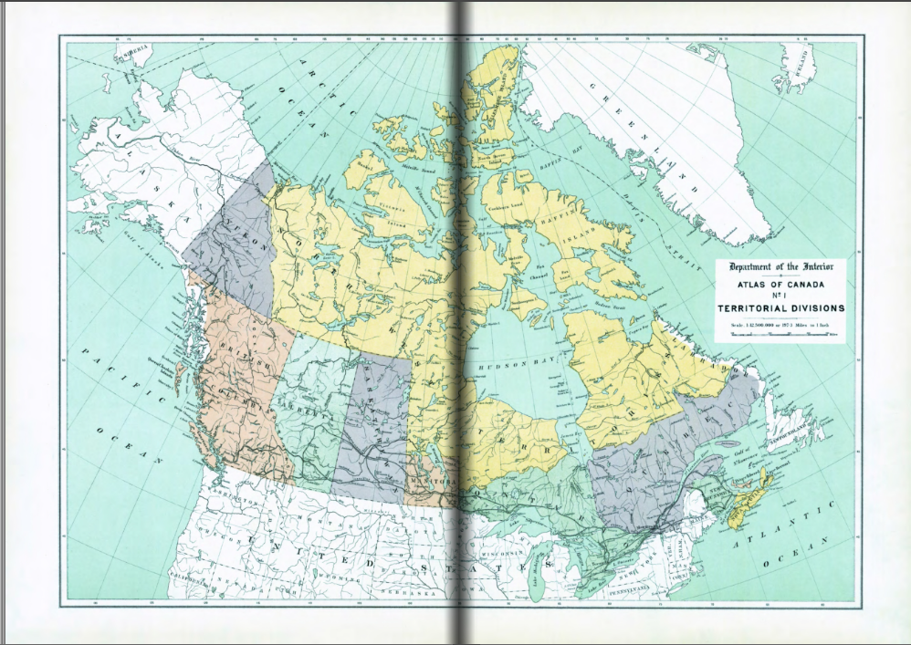
Social Studies and specifically Geography are two subjects that have a long history in Canadian education. The dynamic nature of the map of Canada, marked by shifts in its borders between regions, reveals a historical narrative shaped significantly by the forces of colonialism. As a student and educator, I have seen year after year the learning and memorizing of the standard map of Canada like the one above. Testing and quizzing students to ensure their geography of ‘Canada’ is second nature. This prompts me to question if the study of traditional colonial maps of Canada perpetuates or strengthens a colonial or Eurocentric viewpoint?
Exploring various volumes of Canadian Atlas’ reveals a historical record that prioritizes the perspectives of settlers on the land. Resource locations, quantities, and town populations take precedence, often at the expense of Indigenous culture. Many colonial maps replaced Indigenous place names with European names, erasing the rich linguistic heritage associated with those locations. This practice further diminished the visibility of Indigenous perspectives and histories in the representation of the land. Maps traditionally focused on delineating colonial borders and territories, often neglecting to recognize the existence and sovereignty of distinct Indigenous nations. This omission reinforced a narrative that marginalized Indigenous governance and autonomy. Additionally, by renaming locations with rich resources their relationship with the land was altered to focus on ownership and control impacting their access.
These educational resources that teachers and students often utilize, would impact educational history by providing a narrow vision of Canada’s past. This would affect those students who do not see themselves represented in the curriculum and would continue to hide alternative perspectives from those students who do not know any different. Alternatively, a standard map could highlight biases or stereotypes present in traditional cartography. Educators may then use this as an opportunity to discuss how maps can perpetuate certain narratives and challenge students to think critically about the information they encounter. Questions such as ‘what does this map or historical material tells us about the society and historical landscape that created it?’ could promote important critical thinking and discussions about Canada’s past. Additionally, educators might engage in professional development workshops or training sessions focused on decolonizing the curriculum. These maps could serve as a tangible example during these sessions, prompting teachers to reconsider their instructional materials and methodologies.
It’s important to note that there are current efforts being made to decolonize maps and incorporate Indigenous perspectives in cartography to create maps that reflect their knowledge, languages, and relationships with the land. By acknowledging and addressing the historical issues in mapping, there is an opportunity to foster a more inclusive and respectful representation of Indigenous perspectives on the land.
(2018, December 18). Map Archives. Retrieved January 15, 2024, from https://natural-resources.canada.ca/earth-sciences/geography/atlas-canada/explore-our-maps/map-archives/16868