Author Archives: Michele Koppes

Debris Flow Signatures in the Coast Mountains – Summary of the 2022 Field Season at Qw’elqw’elústen (Mount Meager) and N’skenú7 (Joffre Peak)

BY ISAAC LOWENTHAL WALSH

I joined the Climate and Cryosphere team in May 2022, as a recipient of UBC’s Work Learn International Undergraduate Research Award, to support data collection for Holly Chubb’s doctoral thesis. Over the course of the summer, we have worked in the lab and at two field sites in the Coast Mountains to plan, gather, analyze, and present data exploring the relationships between climate change, cryosphere degradation, and high mountain mass movement events.

Both field sites are located on Líl’wat First Nation territory. Qw’elqw’elústen (Mt. Meager) translates to “cooked face place,” or “really hot face” in Ucwalmícwts, the language of the Líl’wat First Nation. Qw’elqw’elústen is the only currently active Canadian volcano formed during the Quaternary period, sitting roughly 160 km north of Vancouver and 65 km northwest of Pemberton. Quaternary volcanoes such as Qw’elqw’elústen in the South Coast Mountains of British Columbia are often composed of weak rock, which is eroded easily, and often display patterns of rock fall near glacial trimlines (Friele et al., 2008). The August 2010 landslide/debris flow mass movement event at Qw’elqw’elústen was one of the largest in Canadian recorded history (Allstadt, 2013), producing a seismic signature with a magnitude equivalent to M = 2.6 and a flow path measuring a total length of 12.7 km (Guthrie et al., 2012).

Looking northeast at the confluence of Capricorn Creek and Nqempa stswaw̓cw (Meager Creek). The debris flow hurtled down the central valley, superelevated behind the viewer, and split, travelling both upstream (left) and downstream (right) Nqempa stswaw̓cw.


Qw’elqw’elústen field work took place from May 31st to June 3rd, June 9th to the 13th, and on August 18th. We were able to access the runout zones of the 2010 Qw’elqw’elústen Landslide via the Meager Creek Hotsprings FSR, to the west of Líl̓watátkwa7 (Lillooet River), and the Lillooet River FSR, to the east of the river. During our first site visit, we investigated the southwest deposit lobe, taking systematic sediment samples and recording precise survey points using a GNSS receiver system, discussed in further detail below. We enjoyed a consistent weather window of partial sun and mild temperatures. On the second visit, Michele Koppes joined us for the first two days, during which we explored the easternmost deposits, using the same methods, in intermittent showers. On the final two days of our second trip the skies cleared, and we surveyed the eastern debris floodplain in mostly sunny, ~15° C weather.

A field sketch Isaac made, standing on the Meager Creek FSR, looking over the eastern debris floodplain

Holly and Charlotte Mittelstaedt, another field assistant, on top of a hummock in the confluence area of the flowpath.


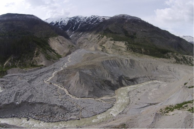
N’skenú7 (Joffre Peak) is located roughly 25 km east of Pemberton, bordering Joffre Lakes Park to the west and the Nlháxten/Cerise Creek Consevancy to the east. The landslide events of May 13 and 16, 2019, lie almost exclusively within the Nlháxten/Cerise Creek Consevancy, a culturally important area to the Líl’wat First Nation. The Líl’wat First Nation shares joint management and supervision of the Conservancy with BC Parks (Geohazard Report, 2019). Similar to Qw’elqw’elústen, N’skenú7 was subject to glaciation during the Quaternary period, and has experienced significant glacial retreat since 1980. A moraine on the now-failed north slope of N’skenú7 marks the maximum Holocene extent of the glacier that used to lie there. The thinning and recession of this glacier eroded and steepened the north slope, and the patchy remnants of this glacier were swept away in the 2019 landslides (Friele, 2020). It is hypothesized that the mass movement events of May 2019 were directly preconditioned by melting permafrost, in conjunction with rapid snowmelt. This resulted in higher groundwater levels and increased porewater pressure within the rock, which would have weakened the structural integrity of the entire face.

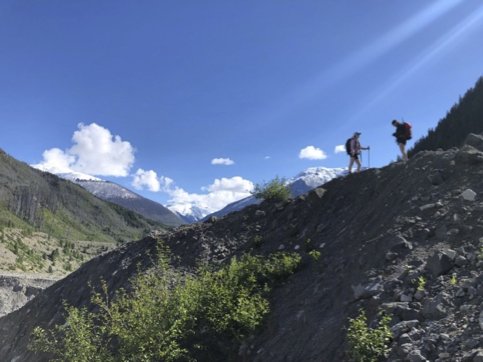
Although significantly smaller in size, the slide at N’skenú7 is more impressive to me, since the boulders are consistently larger, requiring focused scrambling and route planning to traverse, and the entire flow path can be seen in full as you approach the middle. We collected data over the course of three trips, from July 13th to 16th, July 21st to the 22nd, and on August 17th. The site is accessed via the Keith’s hut summer route trail, and we stayed overnight at Keith’s hut, perched on the west ridge of N’skenú7. The first days of the first trip were very hot and cloudless, but the weather turned rainier on the third day. Concerned about the risk associated with crossing the highly unstable deposit while it was wet, we extended our stay an extra night. On the second trip, it was mostly sunny and still, favorable drone-flying weather.

N’skenú7 headscarp. The two failures are exposed, slightly below and to the viewer’s right of the peak. The terminal moraine of the now-extinct Joffre glacier smiles near the base of the mountain.


Methods

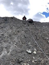
Whilst in the field, we used an EMLID GNSS receiver system to take survey points of significant features with centimeter-level accuracy of their position and elevation. Features that we recorded with the EMLID included the extents of the flow paths, heights and locations of hummocks, and locations of woody dams and large woody debris. The EMLID was also useful in characterizing the general topography of the area. By taking survey points in locations representative of each deposit area, we were able to gather data on the undulating terrain we encountered in all areas of the flow path.

Charlotte surveying with the EMLID Rover in the eastern deposit extent of Qw’elqw’elústen.

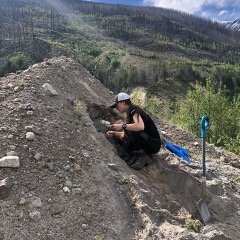
Sediment samples, 40 from Qw’elqw’elústen and 11 from N’skenú7, were dug from significant and characteristic locations in each flow path, using a trowel, to a depth of roughly 15 cm. These samples will be sieved in the coming months to determine their grain-size distribution; the grain-size distribution will be analyzed to understand the rheological dynamics of the debris flow in greater detail. We also took sediment logs in areas where the deposit profile was exposed, noting the degree of mixing and sorting within the deposit.

Charlotte reads the slope height of the eastern plug, measured from the edge of Líl̓watátkwa7’s riverbank.

Holly takes a sample from a hummock at Qw’elqw’elústen that we exposed a cross-section of.


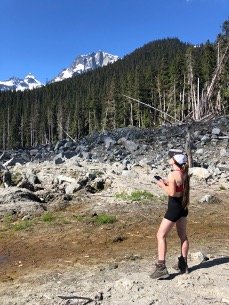
On the second and third visits to each site, we flew the new Mavic 3 cinematography UAS (Unmanned Aircraft System). At Qw’elqw’elústen, we photographed the eastern debris floodplain and the easternmost deposits from the event (east of Líl̓watátkwa7). Flying over N’skenú7, we captured nearly all of the deposit and photographed of the headscarp from afar. These flights captured 3cm-resolution imagery instrumental in the creation of an accurate orthophoto of the N’skenú7 flow path. Orthophoto analysis helps to visualize deposit features—hummocks, fluvial channels, woody dams, etc.—from an overhead angle, on a broader scale.

Holly  flies the cinematography drone at N’skenú7, capturing images for orthophotogrammetry. The headscarp is visible above the trees.


PERSONAL REFLECTION

The field season was not without challenge. At Qw’elqw’elústen, we had multiple grizzly and black bear sightings, and we came back to the campsite one evening to a fresh claw mark in our bear canister. What we anticipated as a relatively simple river crossing to access the plug of the slide turned out to be a ~30m wide impassible torrent of rapids. We felt the presence of a very real danger crossing the flow path at N’skenú7. The eastern buttress hung overhead, cracks propagating into the rock along the fault where the other two buttresses had already failed. Nevertheless, the season was greatly successful. Beyond completing our research objectives and collecting the data we hoped to collect, it was incredible to drink in the beauty of the South Coast Mountains and marvel at the power and scale of these two enormous mass movement events. I feel incredibly blessed to have received the opportunity to work on this project, and while my time in the lab may be coming to a close, I look forward to seeing how the study comes together in the coming year.

Braiding knowledges of braided rivers

The compounding societal and environmental crises of the Anthropocene necessitate a more holistic, critical and systems understanding of our relationship to and with the earth surface. We are now aware that every landscape is touched by Man, a mosaic of recorded artifacts of historical human activity. In order to address the braided realities of this age, geomorphologists need to embrace diverse ways of knowing, most especially indigenous, local and place-based knowledges of landscapes and our role in shaping them. We need to examine how using a  singular, objective standpoint in the scientific process privileges determinism over other ways of seeing and being.


In a recent commentary in Earth Surface Processes and Landforms, I argue that the discipline of geomorphology as it is commonly practiced in the Global North is ill-suited to address the crises of the Anthropocene. In order to reorient the discipline towards a more ethical and societally-relevant role, we need to seek and integrate place-based and situated perspectives and include global, local, and complex frameworks of inquiry into the scientific work of understanding the landscapes we are working in, particularly as so many of the communities most impacted by these changing landscapes are the least involved in guiding our scientific efforts and outcomes.


A holistic and inclusive earth surface science needed in the Anthropocene

The Anthropocene requires a more holistic, critical and systems understanding of our relationship to and with the earth surface. We now live in an era of shifting baselines, where all components of the Earth surface – from black carbon enhancing snowmelt and runoff on mountain tops to levees accelerating erosion and transfer of sediments off continents into the deep ocean – are responding to humans as geomorphic agents and to the cascading effects of anthropogenic climate change. We also now live in an era of shifting assumptions: the more we look to reconstruct or restore a ‘pristine’ landscape free of the imprint of human activity, the more we find such a place has not existed for as long as we have been observing and cataloguing the land, due to centuries of activities such as controlled burning of forests, grazing, or use of the plow. As so eloquently put by Tsing et al. (2017), if one looks closely ‘every landscape is haunted by past ways of life.’ There was a time when searching for pristine landscapes made sense in the context of finding a baseline against which to check the effectiveness of our conceptual models of accelerated process regimes, or to find engineering solutions to human-induced events. However, as Lave et al. (2018) argue “most landscapes are now deeply shaped by human actions and structural inequalities around race, gender, and class [which] incorporate the materiality of nature, creating inextricably eco-social systems. Thus, it no longer makes sense (if it ever did) to concentrate natural science research on pristine systems.” Can our focus on mechanistic/reductionist thinking keep up with the added complexity we need to embrace to help us understand these evolving human-earth systems? 

Moreover, is prediction even viable in the Anthropocene? Given all the uncertainties in both magnitude and timing of forcings and feedbacks between human activity, climate and the earth surface, can we be confident that our understanding of process-responses in the past are indeed the key to the present, let alone the future?  What is the role of models in this era of exceeding planetary boundaries and tipping points (Steffen et al., 2015)? There are limits to the principle of uniformitarianism in this era of shifting baselines. What we need now is a paradigm shift, moving away from predictive, inductive logics and positivist approaches, and towards a fuller embrace of non-equilibrium, emergence and systems thinking. Chaos theory, for example, provides a radically different framework for studying system dynamics, highlighting the limitations inherent in reductionist (towards a steady state) and mechanistic (linear cause and effect-based) analysis of complex earth systems (e.g., Phillips, 1992; 2003, 2011; Murray et al., 2009, Kieler, 2011; Shuster & Just, 2005). What would happen if we were to flip our conceptual models of landscape function and start from an assumption of open systems in disequilibrium, rather than from an assumption of (dynamic) equilibrium and conditions of steady state?


To thoughtfully grapple with considerations of both complexity and causality in landscapes in this new age of uncertainty, we believe the geomorphology community should continue to cooperate with and learn from other disciplines like evolutionary biology, ecology, even neuroscience and epidemiology. Where we once looked to geologists and geographers for ontological framings, followed by leaning on physicists and engineers to distill and quantify the world, we should now be looking to ecologists and climatologists who are throwing out notions of steady state and embracing complexity and post-modern synthesis as foundational frameworks for understanding. For instance, the field of evolutionary biology has started to embrace a radical rethinking of symbiosis, beyond the Darwinian notions of discrete, bounded units, to explain the interactions of animals and their microbiomes, algae and reef-building corals, mycorrhizal fungi and plants (e.g., Margulis, 2008; Gilbert et al., 2012; McFall-Ngai et al., 2013). Perhaps we should start to think of a landscape in the same vein, as a sympoietic organism of interconnected processes and histories (as defined by Haraway (2016)). One arena in which this type of systems thinking is happening is in Critical Zone Observatories (CZOs), in which geomorphologists incorporate interdisciplinary and complex systems approaches that include geochemistry, ecology and systems biology to study the interactions of surface processes and the biosphere (e.g., Anderson et al., 2008; Dethier & Lazarus, 2006; Riebe et al., 2015). Understanding the complex interactions between processes that operate in the Critical Zone, from the canopy to the water table, requires integrated and interdisciplinary approaches that span the granular to the watershed scale. These reframings of inquiry should be applied more broadly across landscapes, beyond the ‘critical zone’ defined by the contemporary weathering front. We should also be asking ourselves if we have the right statistical frameworks to quantify our understanding of landscape complexity. For instance, in the field of ecology there has been renewed interest in using Bayesian approaches and multiple model pathways to analyze systems in which multiple causative factors lead to real-world complexity that is difficult to reduce to a single, isolated mechanism (e.g., Hilborn & Mangel, 1997; Elliott & Brook, 2007). Our mental models of landscape change should embrace these new forms of synthesis and statistical inference, and are beginning to (e.g., Fox et al., 2015; Chandra et al., 2019).

 Other, more holistic, theories are needed to inspire the field, including indigenous and place-based knowledges of the land and our role in shaping it. We need to revisit how we are privileging western science over other ways of seeing and being, particularly as many of the communities that are most impacted by the changing landscapes of the Anthropocene are currently the least involved in guiding the scientific effort. Here, it would be nice to provide a compelling list of examples of what this might look like. However, with the exception of recent calls for the practice of ethno-geomorphology and roadmaps for respectful, bicultural engagement between geoscientists and indigenous knowledge holders in Canada, Hawaii and New Zealand (e.g. Brierley et al., 2018; Kochan, 2015; Swanson, 2008; Wilcock et al., 2013; Wilkinson et al. 2020), much of this work remains to be done. Instead, we invite the earth surface. community to imagine how we might frame new questions that require integrating new (and old) ways of seeing the land and considering landscape change. What is the geomorphic imprint of colonialism, for example (Koch et al., 2019)? Or of white supremacy in North America (Pulido et al., 2019)? What if we start from an indigenous First Nations or Maori perspective that rivers and glaciers are kin and have agency (Cruikshank, 2012; Suzuki & Knudtson, 1992; Wilkinson et al., 2020)?  We are not advocating for any approach in particular. We simply draw attention to the multiplicity of worldviews possible (and necessary) for achieving a more holistic understanding of the Anthropocene, and the ways in which these worldviews have been excluded over the last 70 years of data-centered disciplinary evolution. 

 To truly expand the breadth of the geosciences, we need to interrogate the hierarchies of knowing that our current scientific institutions sustain (King & Tadaki, 2018). This involves acknowledging that the current science of landscapes does not prioritize the perspectives of the Global South, and that we have known this to be true for decades (Kiage, 2013; Stocking, 1995).  Could it be that a fixation on more of the same data at higher and higher resolution is not compatible with the questions relevant to the communities most impacted by landscape change in the Anthropocene, or to the methods most suitable or accessible for conducting research that is relevant there? Optimistically, we hope that asking a greater breadth of questions might also help improve on the diversity crisis that plagues the earth sciences (Bernard & Copperdock, 2018; King et al. 2018; Popp et al., 2019). 

We are now more aware than ever that every landscape is a complex concept with a complex history, that requires both global and local frameworks of inquiry (Garcia-Ruiz, 2015). We need to revisit how we understand landscapes from more than one perspective in time and space. As Sir Ron Cooke suggests in the preface to Roy and Trudgill (2014): “Process is generic – water really does usually, but not always, flow downhill, and the pebble in a stream is battered by predictable forces. But location is unique, and specific landscapes always require interpretation that depends in part on the unique consequences of unique historical events: it is for this reason that what is observed so often conflicts with what is known, and new questions that inspire research come flooding in.”  To bring about these new questions that will inspire our research in the next century, perhaps we need to consider shifting some resources away from the data-gathering effort and towards interdisciplinary and international collaborations, seeking to integrate perspectives not only from the international, heterogeneous scientific community, but from local and indigenous understandings of the landscapes we are working in.

Soundscapes of climate change

The cascading effects of climate change create their own sound; but no one has really bothered to listen. We are recording the sounds of glacial recession and its effects on meltwater runoff downstream, the sounds of ice melting, rocks and sediment moving and people adapting, from the source to the sink. We are following the water rhythms of nature and humans, a dialogue between the lifeblood of both people and the earth system, freshwater.

 To our knowledge, no one has yet created an acoustic database of cryospheric change; this is our attempt to do so. We believe that sonic monitoring may be a useful tool, new to the field of physical geography, to capture and document both the physical and cultural adaptations to climate change.

We are working on an immersive soundscape that will run from the glaciers to the river mouths on various continents, from the coasts of BC and Alaska, to the edges of the Greenland Ice Sheet, to the mighty River Ganga in the Indian Himalayas. Listening to this journey tells the story of the cascading impacts of climate change from the mountains to the ocean. This is an evocative and immersive sonic journey that captures nature along an edge of intense climate impacts. We believe that by hearing and immersing into local soundscapes, the stories of the ice, the water, the people and their cultures will be shared. As the recordings move from cold crackles of supraglacial streams to the cacophonous expanse of the massive rivers, listeners will experience for themselves that these systems – the glaciers and their cultures – are intertwined. 

We hope that our work will allow the Earth and its people to speak for themselves.