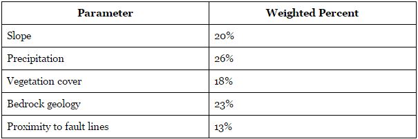
After each layer was provided an appropriately ranged value between 0 and 1, the multi-criteria evaluation model was created. The Spatial Analyst Tool > Overlay > Weighted Sum tool was used to input the raster layers, and weighted values were determined for each layer using the table below.

Table 4. Factor Weightings of parameters contributing to MCE model.
These values were determined based off of other landslide susceptibility research conducted by Shahabi & Hashim (2015) who had determine an MCE model using similar parameters. As the research conducted by Shahabi & Hashim included several parameters not taken into account with our project, the above percentage values had been recalculated to reflect this.
