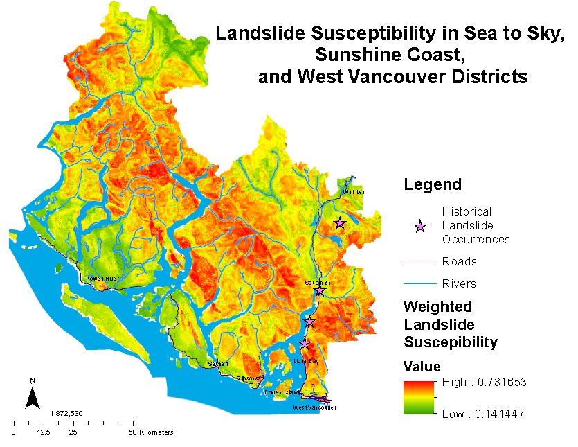
Map 1. Overall landslide susceptibility for the West Vancouver- Sunshine Coast- Sea to Sky region, with greatest risk shown in red.
Map 1 shows landslide susceptibility in the West Vancouver- Sunshine Coast- Sea to Sky region, in addition to historical landslide occurrences that have been recorded in the region. Susceptibility is shown on a scale from high (red) to low (green), with values ranging between 0.1 and 0.8. The weighted range of landslide susceptibility was calculated based on slope, precipitation, proximity to fault lines, vegetation coverage, and bedrock geology. These factors combined gave an indication of slope stability, and therefore susceptibility to landslide occurrence.
Mountainous regions in the Sunshine Coast and Sea to Sky region show the highest susceptibility to landslide occurrence likely due to steep slope, high precipitation, and limited vegetation. Potential landslides in these isolated regions may be important for back country skiers and bikers in the region.
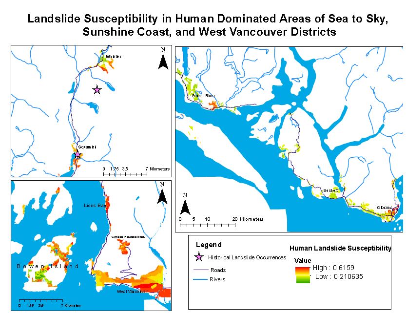
The regional map of weighted landslide susceptibility was clipped to the following regions in order to highlight areas with high human traffic that represent a high risk to landslide occurrences (Map 2):
- Urban;
- Agriculture;
- Residential agriculture mixtures; and
- Recreational activity areas.
The map shows high susceptibility at many points along the highway from West Vancouver to Whistler (Highway 99), which can be expected based off of historical landslide occurrence data recorded along this corridor. Gibsons, Lions Bay, and West Vancouver are other populated regions showing high landslide susceptibility. These areas are important to identify as negative social and economic effects may be induced to the province if landslides were to occur.
 Map 2. Landslide susceptibility in human-dominated regions of West Vancouver- Sunshine Coast- Sea to Sky region.
West Vancouver contains areas of comparatively high landslide susceptibility, along with Cypress Mountain, and Lions Bay. Some isolated sections of Bowen Island were also suggested to represent areas at higher risk of landslides. The southern section of development in Whistler appears to have a higher susceptibility of landslide occurrence, along with moderate-high susceptibility for the city of Squamish. Smaller towns in the Sunshine Coast region mostly exhibit low susceptibility to landslide occurrence.

