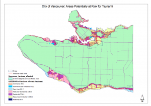
Through Arcmap, I have identified area on Vancouver that are at risk for tsunami. Here is the map below

to view the PDF file of in full resolution, click this link: City of Vancouver: Areas Potentially at Risk for Tsunami
In case of Tsunami, 15.50% of total area of city of Vancouver will be in danger. The danger area is outlined by the criteria of 1km within the shoreline and less than 15m in elevation above sea level. This data is calculated by obtaining the ratio of danger area in Vancouver and the total area of Vancouver in ArcMap. First open attribute table for the data layer with Vancouver land use. Right click shape_area, followed by statistics, then find sum. This will give the total summed area of Vancouver land use, which is 131020600.022 square meter. Within the data frame, there should be another data layer that contains dangered area of Vancouver. This layer is made by intersecting the Vancouver landuse layer and the identitfied danger layer(1km from shoreline, <15m elevtion) created in Arcmap. Within the layer, open attribute table, right click shape_area, followed by statistics, then find sum. The area of danger in Vancouver is 20314805.890824 square meter. Therefore, the percentage of total danger area in Vancouver in case of tsunami is 20314805.890824m^2/131020600.022m^2*100=15.50%.
In case of tsunami, there are many healthcare and educational facilities at risk in the city of Vancouver. For education facilities, there are:
- EMILY CARR INSTITUTE OF ART AND DESIGN
- INSTITDE OF INDIGENOUS GOVERNEMNT
- HENRY HUDSON ELEMENTARY
- FALSE CREEK ELEMENTARY
- ST FRANCIS XAVIER
- VANCOUVER MONTESSORI SCHOOL
- ST JOHN’S INTERNATIONAL
- HERITAGE 3R’S SCHOOL
- ST ANTHONY OF PADUA
- ECOLE ROSE DES VENTS
For healthcare institutions, there are:
- FALSE CREEK RESIDENCE
- VILLA CATHAY CARE HOME
- COAST WEST COMMUNITY HOME
- BROADWAY PENTECOSTAL LODGE
- YALETOWN HOUSE SOCIETY
To find healthcare and education facilities within the danger zone in the city of Vancouver, first add data that contain all the healthcare and education facilities in Vancouver to the layer with identified danger area in Vancouver in ArcMap. Click selection, then select by location, then select Vancouver_education and Vancouver_healthcare layers to the target layer in source layer named Vancouver_Danger. Name of the facilities will appear in attribution table under “show selected records” which will be highlighted in blue.