The proposed project is to evaluate the criticism and recommendations on how to proceed with the project proposal as a natural resource planner. The controversy surrounding the proposed ski resort states that, “climatological considerations rule out reliable skiing on the lower 555m of vertical.”
There were many necessary steps required in order to analyze the data pertaining to the project area which included:
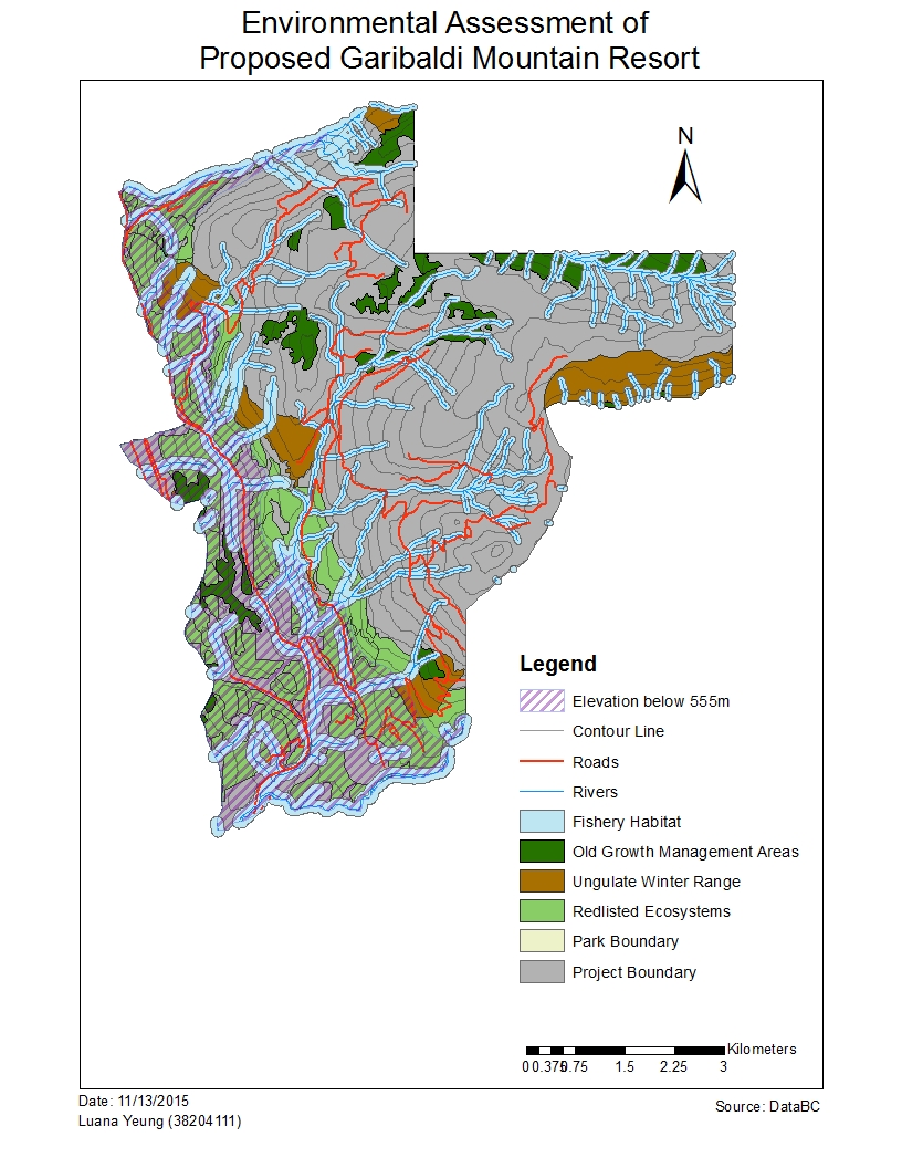
- taking into account the project boundary itself and clipping the vector and raster data relevant to the project area.
- The old growth forest, ungulate winter habitat and endangered plant species polygons were selected by the attributes such as the habitat proximity to the Garibaldi park area, specific endangered plants in a particular biogeoclimatic units etc.
- Buffers for fish habitat were imposed along streams that would run through the project area. All streams below 555m would be given a buffer of 100m and streams above 555m would be given a buffer of 50m as these streams would be less likely to be fish bearing.
- Reclassify the DEM layer to create a new polygon to represent the portion of the project area that would fall below the 555m vertical.
- A union of the old growth forest, fish habitat (river buffers), ungulate winter ranges and redlisted plant species were joined to obtain the total protected area that would appear in the project boundary area.
The general results were that the area occupied by fish habitat, ungulate winter ranges and redlisted plant species would be 55.54% of the proposed project area. The area below 555m of elevation is 29.92%. This area however, overlaps some of the areas containing the ungulate, redlisted species and old growth forests as well.
The two greatest environmental concerns to project development would be the redlisted ecosystems and the fish habitat buffer zones as they cover much of the project area and thus, effecting the areas in which can accommodate a ski resort. Some ways to mitigate the problems is to avoid the protected areas mentioned above and possibly focus project development along the southwest portion of the project area where there aren’t many redlisted plant species and contain streams which have a lesser likelihood of being inhabited by fish.
In terms of the direction of where the project should go, there is not much area available to work with taking into account the sensitive habitats surrounding Garibaldi provincial park. With only a fraction (about 45%) of the total area (about 54 square kilometers) available to work with, it would be too complicated to build of a series of 124 ski trails, 23 lifts and resort accommodation without effecting the protected areas in some way.
Personally, I don’t think the project should be allowed to go through as there is so much area on the mountain already occupied by ecosystems that would be sensitive to the development of an extensive ski resort. My personal opinion does not conflict with what was mentioned in the memo above
Accomplishment Statement: Gained practical skills in ArcGIS and data analysis by creating a new database from a government database and using practical commands (or data mining) in ArcGIS to identify areas of interest (ie ungulate winter range zones, fish habitat areas, redlisted species etc.) and their effects on project development in the Garibaldi mountain resort project area.