Final Project: Analysis of ideal living areas for the Vancouver elderly population according to select areas’ accessibility to needed and preferred public service facilities; areas found using ArcGIS and data from Vancouver data catalogue.
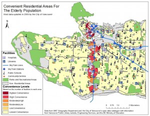
Our goal for this project was to find areas within Vancouver that would be considered ideal living for the local elderly population that are either financially or physically unable to use mobile vehicles. We defined these “convenience areas” as those accessible to general public service facilities, and therefore by their proximity to these facilities. Our GIS analysis would then find these convenience areas within the buffer zones of all facilities. To depict a range of convenience areas, we defined those of “highest convenience” to be those areas within the proximity of all facilities whereas “low convenience” areas were those within the proximity of just (any) one of the select facilities.
Seeing as this project assumes a general audience (i.e. the elderly), our definition of convenience areas is subjective and can thus seem too narrow of a criteria to define the needs and preferences of the elderly regarding their ideal living space. Although this was also part of our original goal, it was understood that more data was needed to provide a more in depth analysis on the matter. As mentioned in the report linked below, data on the needs and preferences of senior living homes, as well as the current and projected financial capabilities and options of the elderly population would benefit further analysis on this topic.
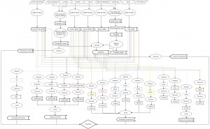
Our method of analysis required multiple steps, as described on the project report below, such that all group members had to work on the map together as opposed to dividing the tasks and working on parts of the map separately.
Project Report attached gives a description of the project, the study area, the methods of our group analysis, results, and a discussion on further research that could improve our method of finding areas that would be ideal living for a range of physically able senior citizens in Vancouver.
Attached below is a flowchart that outlines the procedures of our analysis for finding these ideal living areas through ArcGIS.
Attached below is a map of the areas that we would recommend for senior citizens to live in Vancouver. As described in the report linked above, we define areas of convenience to be those within an 800 to 1000 meter radial proximity of select public service facilities such as parks, community centers, libraries, schools, transit stations, and hospitals.
Accomplishment/s:
Examined ideal living areas for the Vancouver elderly by their accessibility and/or proximity to select public service facilities