Regression Analysis
The regression model equation that was determined with the ordinary least squares function was:
[Ratio change in housing shelter cost] = -0.046371[Ratio change in total number of dwellings] + 0.314712
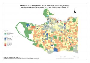
This confirmed a very slightly negative correlation between housing shelter cost change and change in number of dwellings, but given an adjusted r^2 value for this model of -0.00057, it is clear that the relationship between the two variables is weak, and neither can explain the other alone. Further, the map of the residuals outputted shows that there are spatial patterns in how these two variables relate. Closer to the core of the city, it is clear that property values did not rise substantially or fell in relation to the change in the number of dwellings, whereas in the areas that would be dominated by single-family zoning, rises in property value were substantially higher. Could this support the case that single-family zoning is conducive to concentrated speculation, and for that reason as well, these ought to be converted? A spatial autocorrelation analysis of these patterns, and a correlation test to verify if zoning type can statistically predict the local relationship between ∆housing shelter cost ratio and ∆number of dwellings ratio were beyond the scope of this analysis.
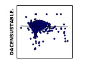
Above: Scatterplot of the results of the regression model for each DA with best fitted linear function line.
Multi-Criteria Evaluation
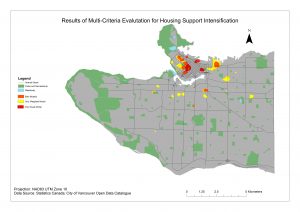
The areas of the city that scored at and above 2 standard deviations from the mean value of the Weighted Sum surfaces for the weighted MCE and the equal weight/sensitiity analysis MCE largely overlapped (in orange). The sensitivity analysis (in red) highlighted areas with high concentrations of transit and services in the downtown area more than the weighted sum MCE (in yellow), whereas the weighted sum MCE was able to point at areas in Kitsilano, Fairview, and Grandview-Woodland where the rental market and unaffordability are more prominent.
Target Zones
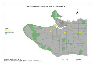
The single-family and two-family zones that intersected with the weighted MCE polygons are largely those areas outside of the downtown core (where multi-family and comprehensive zoning are already prominent) with large rental tenant populations. These indicate opportunities for housing projects like rental-dedicated buildings and denser ground-oriented development like townhomes where there is need, where there is capacity to absorb additional density and population, and where there is relatively more space given present zoning conditions.